![](/images/other/stat-length.png)
![Trail Walking Mazamet - lac des montagnès-lac de laprade-lac des montagnès - Photo](https://media.geolcdn.com/t/1900/400/ext.pjpeg?maxdim=2&url=https%3A%2F%2Fstatic1.geolcdn.com%2Fsiteimages%2Fupload%2Ffiles%2F1553511878bg_sport_marche.png)
lac des montagnès-lac de laprade-lac des montagnès
Dupleix
User
![Length](/images/other/stat-length.png)
Length
24 km
![Max alt](https://static1.geolcdn.com/siteimages/upload/files/1508320355ic_sort_altitude_max_24dp.png)
Max alt
918 m
![Uphill gradient](https://static1.geolcdn.com/siteimages/upload/files/1508320355ic_sort_den_pos_24dp.png)
Uphill gradient
599 m
![Km-Effort](/images/other/stat-length.png)
Km-Effort
32 km
![Min alt](https://static1.geolcdn.com/siteimages/upload/files/1508320355ic_sort_altitude_min_24dp.png)
Min alt
680 m
![Downhill gradient](https://static1.geolcdn.com/siteimages/upload/files/1508320355ic_sort_den_neg_24dp.png)
Downhill gradient
599 m
![Boucle](https://static1.geolcdn.com/siteimages/upload/files/16400158638029165_repeat_loop_refresh_sync_direction_icon.png)
Boucle
Yes
Creation date :
2019-07-23 14:22:54.216
Updated on :
2019-07-23 14:28:03.458
![Walking](https://static1.geolcdn.com/sitytour/trail-icons/101.png)
6h50
Difficulty : Very difficult
![Scan this QR Code to open this trail in the SityTrail application](https://capi.geolives.com/qq0zvz2zws4bq2lad0pu/sitytour/trails/2148505/qr.png?size=200)
FREE GPS app for hiking
About
Trail Walking of 24 km to be discovered at Occitania, Tarn, Mazamet. This trail is proposed by Dupleix.
Description
boucle a cheval entre le tarn et l'aude dans les magnifiques bois de gramentès (a faire surtout a l'automne pour les couleurs) qui nous amene au lac de laprade 11 et retour
Positioning
Country:
France
Region :
Occitania
Department/Province :
Tarn
Municipality :
Mazamet
Location:
Unknown
Start:(Dec)
Start:(UTM)
447141 ; 4812368 (31T) N.
Comments
Trails nearby
![Trail Walking Mazamet - Mazamet - Hautpoul - Photo](https://media.geolcdn.com/t/375/260/ext.jpg?maxdim=2&url=https%3A%2F%2Fservices.sitytrail.com%2FGeolivesWS%2FDownloadMedia.ashx%3FTrailID%3D118725%26Media%3D12918_6.jpg)
![Walking Walking](https://static1.geolcdn.com/sitytour/trail-icons/101.png)
Mazamet - Hautpoul
Walking
Difficult
(1)
Mazamet,
Occitania,
Tarn,
France
![](/images/other/stat-length.png)
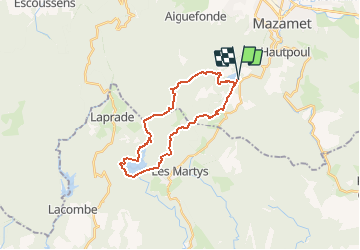
17.4 km | 29 km-effort
6h 30min
![](https://static1.geolcdn.com/siteimages/upload/files/16400158638029165_repeat_loop_refresh_sync_direction_icon.png)
Yes
![Trail Walking Mazamet - Mazamet : chemin de la passerelle - Photo](https://media.geolcdn.com/t/375/260/7fecfe25-55af-4d90-8aa1-4e55b89d75d8.jpg&format=jpg&maxdim=2)
![Walking Walking](https://static1.geolcdn.com/sitytour/trail-icons/101.png)
Mazamet : chemin de la passerelle
Walking
Difficult
Mazamet,
Occitania,
Tarn,
France
![](/images/other/stat-length.png)
9.6 km | 15.5 km-effort
3h 30min
![](https://static1.geolcdn.com/siteimages/upload/files/16400158638029165_repeat_loop_refresh_sync_direction_icon.png)
Yes
![Trail Walking Mazamet - Maeamet la passerelle - Photo](https://media.geolcdn.com/t/375/260/e1724d83-b3f7-4d67-8960-680514083b82.jpg&format=jpg&maxdim=2)
![Walking Walking](https://static1.geolcdn.com/sitytour/trail-icons/101.png)
Maeamet la passerelle
Walking
Medium
Mazamet,
Occitania,
Tarn,
France
![](/images/other/stat-length.png)
4.5 km | 8.6 km-effort
1h 32min
![](https://static1.geolcdn.com/siteimages/upload/files/16400158638029165_repeat_loop_refresh_sync_direction_icon.png)
Yes
![Trail Walking Mazamet - Passerelle de Mazamet et village médiéval d'Hautpoul - Photo](https://media.geolcdn.com/t/375/260/4633c92a-5ccd-498b-87fe-ea2098cce3e4.jpg&format=jpg&maxdim=2)
![Walking Walking](https://static1.geolcdn.com/sitytour/trail-icons/101.png)
Passerelle de Mazamet et village médiéval d'Hautpoul
Walking
Difficult
Mazamet,
Occitania,
Tarn,
France
![](/images/other/stat-length.png)
3.2 km | 6.9 km-effort
1h 41min
![](https://static1.geolcdn.com/siteimages/upload/files/16400158638029165_repeat_loop_refresh_sync_direction_icon.png)
Yes
![Trail Mountain bike Aussillon - Montagne Noire - Les Montagnès - 6754 - UtagawaVTT.com - Photo](https://media.geolcdn.com/t/375/260/ext.jpg?maxdim=2&url=https%3A%2F%2Fstatic1.geolcdn.com%2Fsiteimages%2Fupload%2Ffiles%2F1524743154velo.jpg)
![Mountain bike Mountain bike](https://static1.geolcdn.com/sitytour/trail-icons/202.png)
Montagne Noire - Les Montagnès - 6754 - UtagawaVTT.com
Mountain bike
Difficult
(1)
Aussillon,
Occitania,
Tarn,
France
![](/images/other/stat-length.png)
29 km | 41 km-effort
2h 49min
![](https://static1.geolcdn.com/siteimages/upload/files/16400158638029165_repeat_loop_refresh_sync_direction_icon.png)
Yes
![Trail Walking Mazamet - depuis HAUPOULet en 2 boucles - Photo](https://media.geolcdn.com/t/375/260/c65e16d3-923b-4b11-84c0-295b3af471c1.jpg&format=jpg&maxdim=2)
![Walking Walking](https://static1.geolcdn.com/sitytour/trail-icons/101.png)
depuis HAUPOULet en 2 boucles
Walking
Very easy
Mazamet,
Occitania,
Tarn,
France
![](/images/other/stat-length.png)
14.2 km | 23 km-effort
6h 6min
![](https://static1.geolcdn.com/siteimages/upload/files/16400158638029165_repeat_loop_refresh_sync_direction_icon.png)
Yes
![Trail Walking Mazamet - Labrespy, Hautpoul, St-Pierre des Plots - Photo](https://media.geolcdn.com/t/375/260/ext.jpg?maxdim=2&url=https%3A%2F%2Fstatic1.geolcdn.com%2Fsiteimages%2Fupload%2Ffiles%2F1553511878bg_sport_marche.png)
![Walking Walking](https://static1.geolcdn.com/sitytour/trail-icons/101.png)
Labrespy, Hautpoul, St-Pierre des Plots
Walking
Medium
(1)
Mazamet,
Occitania,
Tarn,
France
![](/images/other/stat-length.png)
9 km | 13.8 km-effort
3h 1min
![](https://static1.geolcdn.com/siteimages/upload/files/16400158638029165_repeat_loop_refresh_sync_direction_icon.png)
Yes
![Trail Walking Mazamet - Labrespy - la Croix de Prat - Photo](https://media.geolcdn.com/t/375/260/ext.jpg?maxdim=2&url=https%3A%2F%2Fstatic1.geolcdn.com%2Fsiteimages%2Fupload%2Ffiles%2F1553511878bg_sport_marche.png)
![Walking Walking](https://static1.geolcdn.com/sitytour/trail-icons/101.png)
Labrespy - la Croix de Prat
Walking
Medium
(1)
Mazamet,
Occitania,
Tarn,
France
![](/images/other/stat-length.png)
13.8 km | 21 km-effort
4h 35min
![](https://static1.geolcdn.com/siteimages/upload/files/16400158638029165_repeat_loop_refresh_sync_direction_icon.png)
Yes
![Trail Walking Aiguefonde - AIGUEFONDE Les Fermes - Photo](https://media.geolcdn.com/t/375/260/ext.jpg?maxdim=2&url=https%3A%2F%2Fstatic1.geolcdn.com%2Fsiteimages%2Fupload%2Ffiles%2F1553511878bg_sport_marche.png)
![Walking Walking](https://static1.geolcdn.com/sitytour/trail-icons/101.png)
AIGUEFONDE Les Fermes
Walking
Medium
(1)
Aiguefonde,
Occitania,
Tarn,
France
![](/images/other/stat-length.png)
11.6 km | 17.9 km-effort
3h 50min
![](https://static1.geolcdn.com/siteimages/upload/files/16400158638029165_repeat_loop_refresh_sync_direction_icon.png)
Yes