![](/images/other/stat-length.png)
![Trail Walking Picherande - Boucle Lac Chauvet - Picherande - Photo](https://media.geolcdn.com/t/1900/400/ext.pjpeg?maxdim=2&url=https%3A%2F%2Fstatic1.geolcdn.com%2Fsiteimages%2Fupload%2Ffiles%2F1553511878bg_sport_marche.png)
Boucle Lac Chauvet - Picherande
s0c7
User
![Length](/images/other/stat-length.png)
Length
15.4 km
![Max alt](https://static1.geolcdn.com/siteimages/upload/files/1508320355ic_sort_altitude_max_24dp.png)
Max alt
1201 m
![Uphill gradient](https://static1.geolcdn.com/siteimages/upload/files/1508320355ic_sort_den_pos_24dp.png)
Uphill gradient
314 m
![Km-Effort](/images/other/stat-length.png)
Km-Effort
19.6 km
![Min alt](https://static1.geolcdn.com/siteimages/upload/files/1508320355ic_sort_altitude_min_24dp.png)
Min alt
1037 m
![Downhill gradient](https://static1.geolcdn.com/siteimages/upload/files/1508320355ic_sort_den_neg_24dp.png)
Downhill gradient
309 m
![Boucle](https://static1.geolcdn.com/siteimages/upload/files/16400158638029165_repeat_loop_refresh_sync_direction_icon.png)
Boucle
Yes
Creation date :
2019-07-18 09:19:36.413
Updated on :
2019-07-18 14:14:23.509
![Walking](https://static1.geolcdn.com/sitytour/trail-icons/101.png)
4h38
Difficulty : Easy
![Scan this QR Code to open this trail in the SityTrail application](https://capi.geolives.com/qq0zvz2zws4bq2lad0pu/sitytour/trails/2143888/qr.png?size=200)
FREE GPS app for hiking
About
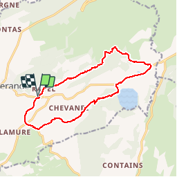
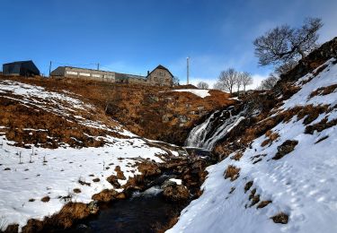
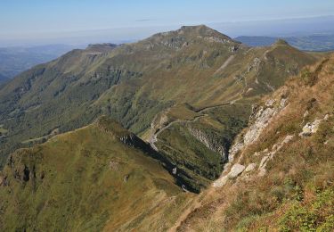
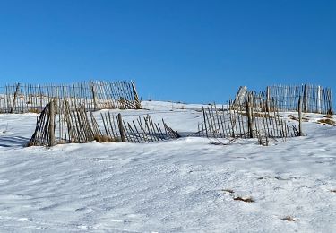
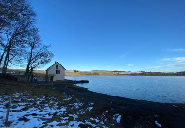
Trail Walking of 15.4 km to be discovered at Auvergne-Rhône-Alpes, Puy-de-Dôme, Picherande. This trail is proposed by s0c7.
Description
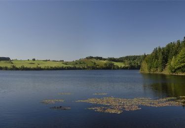
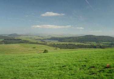
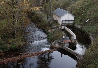
Agréable ballade facile à travers la campagne. Ne pas tenir compte du temps, nous avons fait plein de pauses photos : cascade, flore et pour finir un arrêt à la braasserie Gaïa
Positioning
Country:
France
Region :
Auvergne-Rhône-Alpes
Department/Province :
Puy-de-Dôme
Municipality :
Picherande
Location:
Unknown
Start:(Dec)
Start:(UTM)
483264 ; 5034160 (31T) N.
Comments
Trails nearby
![Trail Walking Saint-Genès-Champespe - St_Genes_Champespe_Cregut - Photo](https://media.geolcdn.com/t/375/260/d93c4e21-ddbf-43da-aec3-a0213d2701fb.jpg&format=jpg&maxdim=2)
![Walking Walking](https://static1.geolcdn.com/sitytour/trail-icons/101.png)
St_Genes_Champespe_Cregut
Walking
Medium
(1)
Saint-Genès-Champespe,
Auvergne-Rhône-Alpes,
Puy-de-Dôme,
France
![](/images/other/stat-length.png)
14 km | 17.7 km-effort
4h 15min
![](https://static1.geolcdn.com/siteimages/upload/files/16400158638029165_repeat_loop_refresh_sync_direction_icon.png)
Yes
![Trail Walking Saint-Genès-Champespe - lac de cregut - Photo](https://media.geolcdn.com/t/375/260/d8a1ee5f-66ec-486a-ad1e-01dafc4ad7f3.jpg&format=jpg&maxdim=2)
![Walking Walking](https://static1.geolcdn.com/sitytour/trail-icons/101.png)
lac de cregut
Walking
Very easy
(1)
Saint-Genès-Champespe,
Auvergne-Rhône-Alpes,
Puy-de-Dôme,
France
![](/images/other/stat-length.png)
14.7 km | 18.6 km-effort
5h 23min
![](https://static1.geolcdn.com/siteimages/upload/files/16400158638029165_repeat_loop_refresh_sync_direction_icon.png)
Yes
![Trail Mountain bike Picherande - Espace VTT FFC du Sancy - Circuit n°10 - L'Escudor - Secteur Picherande - Photo](https://media.geolcdn.com/t/375/260/ext.jpg?maxdim=2&url=https%3A%2F%2Fservices.sitytrail.com%2FGeolivesWS%2FDownloadMedia.ashx%3FTrailID%3D106754%26Media%3D11421_2.jpg)
![Mountain bike Mountain bike](https://static1.geolcdn.com/sitytour/trail-icons/202.png)
Espace VTT FFC du Sancy - Circuit n°10 - L'Escudor - Secteur Picherande
Mountain bike
Difficult
(1)
Picherande,
Auvergne-Rhône-Alpes,
Puy-de-Dôme,
France
![](/images/other/stat-length.png)
14.9 km | 19.8 km-effort
1h 10min
![](https://static1.geolcdn.com/siteimages/upload/files/16400158638029165_repeat_loop_refresh_sync_direction_icon.png)
Yes
![Trail On foot Égliseneuve-d'Entraigues - La visade - Photo](https://media.geolcdn.com/t/375/260/b29b9335-03fb-40ee-b496-851e91bece85.jpeg&format=jpg&maxdim=2)
![On foot On foot](https://static1.geolcdn.com/sitytour/trail-icons/100.png)
La visade
On foot
Easy
Égliseneuve-d'Entraigues,
Auvergne-Rhône-Alpes,
Puy-de-Dôme,
France
![](/images/other/stat-length.png)
11.7 km | 15.2 km-effort
3h 26min
![](https://static1.geolcdn.com/siteimages/upload/files/16400158638029165_repeat_loop_refresh_sync_direction_icon.png)
Yes
![Trail On foot Picherande - Le Lac Chauvet - Photo](https://media.geolcdn.com/t/375/260/0a06c9c2-0789-44b7-b2be-bed9042bb6fe.jpeg&format=jpg&maxdim=2)
![On foot On foot](https://static1.geolcdn.com/sitytour/trail-icons/100.png)
Le Lac Chauvet
On foot
Easy
Picherande,
Auvergne-Rhône-Alpes,
Puy-de-Dôme,
France
![](/images/other/stat-length.png)
13.2 km | 16.7 km-effort
3h 47min
![](https://static1.geolcdn.com/siteimages/upload/files/16400158638029165_repeat_loop_refresh_sync_direction_icon.png)
Yes
![Trail On foot Picherande - La Fontaine Salée - Photo](https://media.geolcdn.com/t/375/260/6bb9750a-cfda-4ba6-aad3-02a83bb6e73a.jpeg&format=jpg&maxdim=2)
![On foot On foot](https://static1.geolcdn.com/sitytour/trail-icons/100.png)
La Fontaine Salée
On foot
Medium
Picherande,
Auvergne-Rhône-Alpes,
Puy-de-Dôme,
France
![](/images/other/stat-length.png)
20 km | 29 km-effort
6h 41min
![](https://static1.geolcdn.com/siteimages/upload/files/16400158638029165_repeat_loop_refresh_sync_direction_icon.png)
Yes
![Trail Walking Saint-Genès-Champespe - Lac de la Crégut_CG - Photo](https://media.geolcdn.com/t/375/260/ext.jpg?maxdim=2&url=https%3A%2F%2Fstatic1.geolcdn.com%2Fsiteimages%2Fupload%2Ffiles%2F1553511878bg_sport_marche.png)
![Walking Walking](https://static1.geolcdn.com/sitytour/trail-icons/101.png)
Lac de la Crégut_CG
Walking
Medium
(1)
Saint-Genès-Champespe,
Auvergne-Rhône-Alpes,
Puy-de-Dôme,
France
![](/images/other/stat-length.png)
14 km | 17.8 km-effort
3h 55min
![](https://static1.geolcdn.com/siteimages/upload/files/16400158638029165_repeat_loop_refresh_sync_direction_icon.png)
Yes
![Trail Walking Picherande - Picherande - Photo](https://media.geolcdn.com/t/375/260/3cb6325e-0604-4dca-8d4c-904f68d7fe48.jpg&format=jpg&maxdim=2)
![Walking Walking](https://static1.geolcdn.com/sitytour/trail-icons/101.png)
Picherande
Walking
Very easy
Picherande,
Auvergne-Rhône-Alpes,
Puy-de-Dôme,
France
![](/images/other/stat-length.png)
9.4 km | 12.3 km-effort
2h 19min
![](https://static1.geolcdn.com/siteimages/upload/files/16400158638029165_repeat_loop_refresh_sync_direction_icon.png)
Yes
![Trail Walking Picherande - Lac Chauvet - Photo](https://media.geolcdn.com/t/375/260/63249f4f-56b6-4620-9425-6934dfecb22f.jpg&format=jpg&maxdim=2)
![Walking Walking](https://static1.geolcdn.com/sitytour/trail-icons/101.png)
Lac Chauvet
Walking
Very easy
Picherande,
Auvergne-Rhône-Alpes,
Puy-de-Dôme,
France
![](/images/other/stat-length.png)
7.2 km | 9.2 km-effort
2h 10min
![](https://static1.geolcdn.com/siteimages/upload/files/16400158638029165_repeat_loop_refresh_sync_direction_icon.png)
Yes