![](/images/other/stat-length.png)
![Trail Walking Durtol - Durtol_Cote_Pegnu - Photo](https://media.geolcdn.com/t/1900/400/7c246ba6-59d4-4d2d-af70-816c9d62d2cf.jpg&format=pjpeg&maxdim=2)
Durtol_Cote_Pegnu
jagarnier
User GUIDE
![Length](/images/other/stat-length.png)
Length
6.1 km
![Max alt](https://static1.geolcdn.com/siteimages/upload/files/1508320355ic_sort_altitude_max_24dp.png)
Max alt
754 m
![Uphill gradient](https://static1.geolcdn.com/siteimages/upload/files/1508320355ic_sort_den_pos_24dp.png)
Uphill gradient
224 m
![Km-Effort](/images/other/stat-length.png)
Km-Effort
9.1 km
![Min alt](https://static1.geolcdn.com/siteimages/upload/files/1508320355ic_sort_altitude_min_24dp.png)
Min alt
532 m
![Downhill gradient](https://static1.geolcdn.com/siteimages/upload/files/1508320355ic_sort_den_neg_24dp.png)
Downhill gradient
224 m
![Boucle](https://static1.geolcdn.com/siteimages/upload/files/16400158638029165_repeat_loop_refresh_sync_direction_icon.png)
Boucle
Yes
Creation date :
2019-07-12 13:24:45.206
Updated on :
2024-01-04 16:34:41.883
![Walking](https://static1.geolcdn.com/sitytour/trail-icons/101.png)
2h00
Difficulty : Easy
![Scan this QR Code to open this trail in the SityTrail application](https://capi.geolives.com/qq0zvz2zws4bq2lad0pu/sitytour/trails/2137973/qr.png?size=200)
FREE GPS app for hiking
About
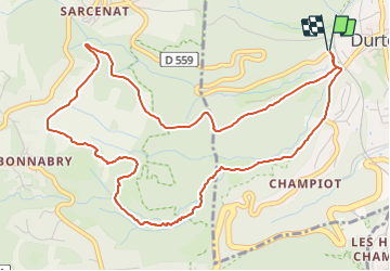
Trail Walking of 6.1 km to be discovered at Auvergne-Rhône-Alpes, Puy-de-Dôme, Durtol. This trail is proposed by jagarnier.
Description
Une randonnée qui permet de dominer la faille de la Limagne au milieu de vergers et de vignes. De vieux châtaigniers nous accueillent sur le plateau de Bonnabry à Sarcenat, patrie de Teilhard de Chardin.
Positioning
Country:
France
Region :
Auvergne-Rhône-Alpes
Department/Province :
Puy-de-Dôme
Municipality :
Durtol
Location:
Unknown
Start:(Dec)
Start:(UTM)
503748 ; 5071228 (31T) N.
Comments
Trails nearby
![Trail Walking Royat - Royat_Haut_Chamalieres - Photo](https://media.geolcdn.com/t/375/260/b2b61a3d-216c-41ca-b3c5-c12e3597cfee.jpg&format=jpg&maxdim=2)
![Walking Walking](https://static1.geolcdn.com/sitytour/trail-icons/101.png)
Royat_Haut_Chamalieres
Walking
Medium
(2)
Royat,
Auvergne-Rhône-Alpes,
Puy-de-Dôme,
France
![](/images/other/stat-length.png)
10.8 km | 16.4 km-effort
3h 15min
![](https://static1.geolcdn.com/siteimages/upload/files/16400158638029165_repeat_loop_refresh_sync_direction_icon.png)
Yes
![Trail Walking Blanzat - Blanzat_Plateau_Bade - Photo](https://media.geolcdn.com/t/375/260/0f6960c3-6461-4500-bc08-d408282d7c8a.jpg&format=jpg&maxdim=2)
![Walking Walking](https://static1.geolcdn.com/sitytour/trail-icons/101.png)
Blanzat_Plateau_Bade
Walking
Easy
(1)
Blanzat,
Auvergne-Rhône-Alpes,
Puy-de-Dôme,
France
![](/images/other/stat-length.png)
5.5 km | 7.2 km-effort
1h 45min
![](https://static1.geolcdn.com/siteimages/upload/files/16400158638029165_repeat_loop_refresh_sync_direction_icon.png)
Yes
![Trail Walking Royat - Royat_Paradis - Photo](https://media.geolcdn.com/t/375/260/40a920bf-98ae-44a7-8509-dbb3cd58b58b.jpg&format=jpg&maxdim=2)
![Walking Walking](https://static1.geolcdn.com/sitytour/trail-icons/101.png)
Royat_Paradis
Walking
Easy
(1)
Royat,
Auvergne-Rhône-Alpes,
Puy-de-Dôme,
France
![](/images/other/stat-length.png)
7.1 km | 10 km-effort
2h 15min
![](https://static1.geolcdn.com/siteimages/upload/files/16400158638029165_repeat_loop_refresh_sync_direction_icon.png)
Yes
![Trail Walking Royat - Royat_Chemin_Ecoliers - Photo](https://media.geolcdn.com/t/375/260/45acbefc-a834-46ca-83ad-58408101e47d.jpg&format=jpg&maxdim=2)
![Walking Walking](https://static1.geolcdn.com/sitytour/trail-icons/101.png)
Royat_Chemin_Ecoliers
Walking
Medium
(3)
Royat,
Auvergne-Rhône-Alpes,
Puy-de-Dôme,
France
![](/images/other/stat-length.png)
6.9 km | 11.2 km-effort
2h 0min
![](https://static1.geolcdn.com/siteimages/upload/files/16400158638029165_repeat_loop_refresh_sync_direction_icon.png)
Yes
![Trail Walking Chanat-la-Mouteyre - Chanat_Trois_Villages - Photo](https://media.geolcdn.com/t/375/260/f6aed3b2-f876-470f-b6b5-0e9d2ed9b804.jpg&format=jpg&maxdim=2)
![Walking Walking](https://static1.geolcdn.com/sitytour/trail-icons/101.png)
Chanat_Trois_Villages
Walking
Medium
(1)
Chanat-la-Mouteyre,
Auvergne-Rhône-Alpes,
Puy-de-Dôme,
France
![](/images/other/stat-length.png)
10 km | 14 km-effort
3h 0min
![](https://static1.geolcdn.com/siteimages/upload/files/16400158638029165_repeat_loop_refresh_sync_direction_icon.png)
Yes
![Trail Walking Sayat - Sayat_Repaire_Gaulois - Photo](https://media.geolcdn.com/t/375/260/d799b2b9-9f9f-418d-82a8-76cd808ed9e7.jpg&format=jpg&maxdim=2)
![Walking Walking](https://static1.geolcdn.com/sitytour/trail-icons/101.png)
Sayat_Repaire_Gaulois
Walking
Easy
(1)
Sayat,
Auvergne-Rhône-Alpes,
Puy-de-Dôme,
France
![](/images/other/stat-length.png)
6.1 km | 9.3 km-effort
1h 59min
![](https://static1.geolcdn.com/siteimages/upload/files/16400158638029165_repeat_loop_refresh_sync_direction_icon.png)
Yes
![Trail Walking Royat - Oclede-GraveNoire-Charade_T - Photo](https://media.geolcdn.com/t/375/260/acb0504d-7485-4653-a888-66c4efb79c9d.jpg&format=jpg&maxdim=2)
![Walking Walking](https://static1.geolcdn.com/sitytour/trail-icons/101.png)
Oclede-GraveNoire-Charade_T
Walking
Medium
(1)
Royat,
Auvergne-Rhône-Alpes,
Puy-de-Dôme,
France
![](/images/other/stat-length.png)
10.3 km | 15.9 km-effort
1h 36min
![](https://static1.geolcdn.com/siteimages/upload/files/16400158638029165_repeat_loop_refresh_sync_direction_icon.png)
Yes
![Trail Walking Orcines - Puy de Pariou - Photo](https://media.geolcdn.com/t/375/260/ext.jpg?maxdim=2&url=https%3A%2F%2Fservices.sitytrail.com%2FGeolivesWS%2FDownloadMedia.ashx%3FTrailID%3D146546%26Media%3D20120813113037.jpeg)
![Walking Walking](https://static1.geolcdn.com/sitytour/trail-icons/101.png)
Puy de Pariou
Walking
Medium
(1)
Orcines,
Auvergne-Rhône-Alpes,
Puy-de-Dôme,
France
![](/images/other/stat-length.png)
8.6 km | 12.4 km-effort
3h 7min
![](https://static1.geolcdn.com/siteimages/upload/files/16400158638029165_repeat_loop_refresh_sync_direction_icon.png)
Yes
![Trail Walking Orcines - Montagne Percée - Chamalières - Photo](https://media.geolcdn.com/t/375/260/ext.jpg?maxdim=2&url=https%3A%2F%2Fservices.sitytrail.com%2FGeolivesWS%2FDownloadMedia.ashx%3FTrailID%3D107719%26Media%3D12751_1.jpg)
![Walking Walking](https://static1.geolcdn.com/sitytour/trail-icons/101.png)
Montagne Percée - Chamalières
Walking
Medium
(2)
Orcines,
Auvergne-Rhône-Alpes,
Puy-de-Dôme,
France
![](/images/other/stat-length.png)
5.5 km | 8.3 km-effort
1h 30min
![](https://static1.geolcdn.com/siteimages/upload/files/16400158638029165_repeat_loop_refresh_sync_direction_icon.png)
Yes