La Sarthe-08-Malicorne - Sablé SityTrail > Trails > Outdoor > France > Pays de la Loire > Sarthe > Malicorne-sur-Sarthe SityTrail > Trails > Outdoor > France > Pays de la Loire > Sarthe > Malicorne-sur-Sarthe La Sarthe-08-Malicorne - Sablé SERUS User 3D © OpenStreetMap contributors Length 26 km Max alt 42 m Uphill gradient 155 m Km-Effort 28 km Min alt 22 m Downhill gradient 159 m Boucle No Creation date : 2019-05-19 20:38:45.266 Updated on : 2021-04-06 20:09:17.437 (0 Reviews) Walking 6h13 Difficulty : Easy FREE GPS app for hiking SityTrail IGN / Geographical institutes SityTrail World The world is yours! About Trail Walking of 26 km to be discovered at Pays de la Loire, Sarthe, Malicorne-sur-Sarthe. This trail is proposed by SERUS. Description en canoé Legends | More details (PDF) Elevation profile Legends > 15% 15% - 10% 10% - 5% flat 5% - 10% 10% - 15% 15% - 30% > 30% Positioning Country: France Region : Pays de la Loire Department/Province : Sarthe Municipality : Malicorne-sur-Sarthe Location: Unknown Start:(Dec) 47.814163 / -0.090036 Start:(UTM) 717840 ; 5299746 (30T) N. Comments Please log in to post a review or rate the element gerard72 2019-09-05 07:57:48.414 heureusement que SERUS a précisé CANOE car la rando est classée en randonnée à pied dans sity-trail ! Trails nearby gerard72 Malicorne Walking Medium Malicorne-sur-Sarthe, Pays de la Loire, Sarthe, France 
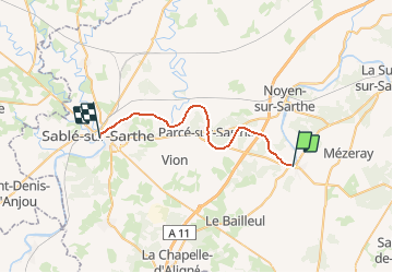
12.5 km | 13.8 km-effort 3h 5min Yes plevier Tue 20 Sep 2022 Road bike Difficult Mézeray, Pays de la Loire, Sarthe, France 31 km | 35 km-effort 2h 6min No yoyozen maicorne Mountain bike Easy Malicorne-sur-Sarthe, Pays de la Loire, Sarthe, France 8.9 km | 9.9 km-effort Unknown Yes
gerard72 2019-09-05 07:57:48.414 heureusement que SERUS a précisé CANOE car la rando est classée en randonnée à pied dans sity-trail !
heureusement que SERUS a précisé CANOE car la rando est classée en randonnée à pied dans sity-trail !