![](/images/other/stat-length.png)
![Trail Walking Saint-Yrieix-le-Déjalat - St-Yrieix-le-Déjalat - butte de Montamar - Photo](https://media.geolcdn.com/t/1900/400/ext.pjpeg?maxdim=2&url=https%3A%2F%2Fstatic1.geolcdn.com%2Fsiteimages%2Fupload%2Ffiles%2F1553511878bg_sport_marche.png)
St-Yrieix-le-Déjalat - butte de Montamar
cron
User
![Length](/images/other/stat-length.png)
Length
19.7 km
![Max alt](https://static1.geolcdn.com/siteimages/upload/files/1508320355ic_sort_altitude_max_24dp.png)
Max alt
809 m
![Uphill gradient](https://static1.geolcdn.com/siteimages/upload/files/1508320355ic_sort_den_pos_24dp.png)
Uphill gradient
466 m
![Km-Effort](/images/other/stat-length.png)
Km-Effort
26 km
![Min alt](https://static1.geolcdn.com/siteimages/upload/files/1508320355ic_sort_altitude_min_24dp.png)
Min alt
629 m
![Downhill gradient](https://static1.geolcdn.com/siteimages/upload/files/1508320355ic_sort_den_neg_24dp.png)
Downhill gradient
464 m
![Boucle](https://static1.geolcdn.com/siteimages/upload/files/16400158638029165_repeat_loop_refresh_sync_direction_icon.png)
Boucle
Yes
Creation date :
2019-07-10 17:00:10.637
Updated on :
2019-09-12 12:54:02.284
![Walking](https://static1.geolcdn.com/sitytour/trail-icons/101.png)
5h31
Difficulty : Medium
![Scan this QR Code to open this trail in the SityTrail application](https://capi.geolives.com/qq0zvz2zws4bq2lad0pu/sitytour/trails/2136640/qr.png?size=200)
FREE GPS app for hiking
About
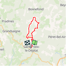
Trail Walking of 19.7 km to be discovered at New Aquitaine, Corrèze, Saint-Yrieix-le-Déjalat. This trail is proposed by cron.
Description
Cheminer avec prudence le long de la D 18 même si l'on croise très peu de voitures !
Un peu trop de bitume sur le parcours mais les chemins forestiers ont trop souvent disparus ...
Positioning
Country:
France
Region :
New Aquitaine
Department/Province :
Corrèze
Municipality :
Saint-Yrieix-le-Déjalat
Location:
Unknown
Start:(Dec)
Start:(UTM)
419511 ; 5034292 (31T) N.
Comments
Trails nearby
![Trail Walking Égletons - Entre Vedrenne et la Brette - variante courte - Égletons - Pays d'Égletons - Photo](https://media.geolcdn.com/t/375/260/ext.jpg?maxdim=2&url=https%3A%2F%2Fservices.sitytrail.com%2FGeolivesWS%2FDownloadMedia.ashx%3FTrailID%3D112292%26Media%3D10302_1.jpg)
![Walking Walking](https://static1.geolcdn.com/sitytour/trail-icons/101.png)
Entre Vedrenne et la Brette - variante courte - Égletons - Pays d'Égletons
Walking
Medium
Égletons,
New Aquitaine,
Corrèze,
France
![](/images/other/stat-length.png)
8.7 km | 11.5 km-effort
2h 0min
![](https://static1.geolcdn.com/siteimages/upload/files/16400158638029165_repeat_loop_refresh_sync_direction_icon.png)
Yes
![Trail Equestrian Égletons - Entre Vedrenne et la Brette - Egletons - Pays d'Egletons - Photo](https://media.geolcdn.com/t/375/260/ext.jpg?maxdim=2&url=https%3A%2F%2Fservices.sitytrail.com%2FGeolivesWS%2FDownloadMedia.ashx%3FTrailID%3D112289%26Media%3D10299_1.jpg)
![Equestrian Equestrian](https://static1.geolcdn.com/sitytour/trail-icons/300.png)
Entre Vedrenne et la Brette - Egletons - Pays d'Egletons
Equestrian
Medium
(1)
Égletons,
New Aquitaine,
Corrèze,
France
![](/images/other/stat-length.png)
11.7 km | 15.6 km-effort
2h 0min
![](https://static1.geolcdn.com/siteimages/upload/files/16400158638029165_repeat_loop_refresh_sync_direction_icon.png)
Yes
![Trail Mountain bike Égletons - Entre Vedrenne et la Brette - Egletons - Pays d'Egletons - Photo](https://media.geolcdn.com/t/375/260/ext.jpg?maxdim=2&url=https%3A%2F%2Fservices.sitytrail.com%2FGeolivesWS%2FDownloadMedia.ashx%3FTrailID%3D112288%26Media%3D10299_1.jpg)
![Mountain bike Mountain bike](https://static1.geolcdn.com/sitytour/trail-icons/202.png)
Entre Vedrenne et la Brette - Egletons - Pays d'Egletons
Mountain bike
Medium
Égletons,
New Aquitaine,
Corrèze,
France
![](/images/other/stat-length.png)
11.7 km | 15.6 km-effort
1h 0min
![](https://static1.geolcdn.com/siteimages/upload/files/16400158638029165_repeat_loop_refresh_sync_direction_icon.png)
Yes
![Trail Walking Égletons - Entre Vedrenne et la Brette - Egletons - Pays d'Egletons - Photo](https://media.geolcdn.com/t/375/260/ext.jpg?maxdim=2&url=https%3A%2F%2Fservices.sitytrail.com%2FGeolivesWS%2FDownloadMedia.ashx%3FTrailID%3D112287%26Media%3D10299_1.jpg)
![Walking Walking](https://static1.geolcdn.com/sitytour/trail-icons/101.png)
Entre Vedrenne et la Brette - Egletons - Pays d'Egletons
Walking
Medium
Égletons,
New Aquitaine,
Corrèze,
France
![](/images/other/stat-length.png)
11.7 km | 15.6 km-effort
3h 15min
![](https://static1.geolcdn.com/siteimages/upload/files/16400158638029165_repeat_loop_refresh_sync_direction_icon.png)
Yes
![Trail Mountain bike Saint-Yrieix-le-Déjalat - La Butte de Montamar - Saint Yrieix le Déjalat - Pays d'Egletons - Photo](https://media.geolcdn.com/t/375/260/ext.jpg?maxdim=2&url=https%3A%2F%2Fservices.sitytrail.com%2FGeolivesWS%2FDownloadMedia.ashx%3FTrailID%3D112233%26Media%3D10148_1.jpg)
![Mountain bike Mountain bike](https://static1.geolcdn.com/sitytour/trail-icons/202.png)
La Butte de Montamar - Saint Yrieix le Déjalat - Pays d'Egletons
Mountain bike
Difficult
Saint-Yrieix-le-Déjalat,
New Aquitaine,
Corrèze,
France
![](/images/other/stat-length.png)
13.3 km | 18.2 km-effort
1h 15min
![](https://static1.geolcdn.com/siteimages/upload/files/16400158638029165_repeat_loop_refresh_sync_direction_icon.png)
Yes
![Trail Walking Saint-Yrieix-le-Déjalat - La Butte de Montamar - Saint Yrieix le Déjalat - Pays d'Egletons - Photo](https://media.geolcdn.com/t/375/260/ext.jpg?maxdim=2&url=https%3A%2F%2Fservices.sitytrail.com%2FGeolivesWS%2FDownloadMedia.ashx%3FTrailID%3D112232%26Media%3D10148_1.jpg)
![Walking Walking](https://static1.geolcdn.com/sitytour/trail-icons/101.png)
La Butte de Montamar - Saint Yrieix le Déjalat - Pays d'Egletons
Walking
Difficult
Saint-Yrieix-le-Déjalat,
New Aquitaine,
Corrèze,
France
![](/images/other/stat-length.png)
13.3 km | 18.2 km-effort
3h 30min
![](https://static1.geolcdn.com/siteimages/upload/files/16400158638029165_repeat_loop_refresh_sync_direction_icon.png)
Yes
![Trail Equestrian Égletons - Entre Vedrenne et la Brette - Photo](https://media.geolcdn.com/t/375/260/ext.jpg?maxdim=2&url=https%3A%2F%2Fservices.sitytrail.com%2FGeolivesWS%2FDownloadMedia.ashx%3FTrailID%3D109417%26Media%3D3747_1.jpg)
![Equestrian Equestrian](https://static1.geolcdn.com/sitytour/trail-icons/300.png)
Entre Vedrenne et la Brette
Equestrian
Medium
Égletons,
New Aquitaine,
Corrèze,
France
![](/images/other/stat-length.png)
11.7 km | 15.7 km-effort
1h 45min
![](https://static1.geolcdn.com/siteimages/upload/files/16400158638029165_repeat_loop_refresh_sync_direction_icon.png)
Yes
![Trail Mountain bike Égletons - Entre Vedrenne et la Brette - Photo](https://media.geolcdn.com/t/375/260/ext.jpg?maxdim=2&url=https%3A%2F%2Fservices.sitytrail.com%2FGeolivesWS%2FDownloadMedia.ashx%3FTrailID%3D109416%26Media%3D3747_1.jpg)
![Mountain bike Mountain bike](https://static1.geolcdn.com/sitytour/trail-icons/202.png)
Entre Vedrenne et la Brette
Mountain bike
Medium
Égletons,
New Aquitaine,
Corrèze,
France
![](/images/other/stat-length.png)
11.7 km | 15.7 km-effort
1h 0min
![](https://static1.geolcdn.com/siteimages/upload/files/16400158638029165_repeat_loop_refresh_sync_direction_icon.png)
Yes
![Trail Walking Égletons - Entre Vedrenne et la Brette - Photo](https://media.geolcdn.com/t/375/260/ext.jpg?maxdim=2&url=https%3A%2F%2Fservices.sitytrail.com%2FGeolivesWS%2FDownloadMedia.ashx%3FTrailID%3D109415%26Media%3D3747_1.jpg)
![Walking Walking](https://static1.geolcdn.com/sitytour/trail-icons/101.png)
Entre Vedrenne et la Brette
Walking
Medium
Égletons,
New Aquitaine,
Corrèze,
France
![](/images/other/stat-length.png)
11.7 km | 15.7 km-effort
3h 15min
![](https://static1.geolcdn.com/siteimages/upload/files/16400158638029165_repeat_loop_refresh_sync_direction_icon.png)
Yes