![](/images/other/stat-length.png)
![Trail Walking Bernkastel-Kues - Berncastel 15 Km - Photo](https://media.geolcdn.com/t/1900/400/89092245-0c94-40e7-aa94-3249dcf22f46.png&format=pjpeg&maxdim=2)
Berncastel 15 Km
rvapeldo
User GUIDE
![Length](/images/other/stat-length.png)
Length
14.1 km
![Max alt](https://static1.geolcdn.com/siteimages/upload/files/1508320355ic_sort_altitude_max_24dp.png)
Max alt
419 m
![Uphill gradient](https://static1.geolcdn.com/siteimages/upload/files/1508320355ic_sort_den_pos_24dp.png)
Uphill gradient
657 m
![Km-Effort](/images/other/stat-length.png)
Km-Effort
23 km
![Min alt](https://static1.geolcdn.com/siteimages/upload/files/1508320355ic_sort_altitude_min_24dp.png)
Min alt
110 m
![Downhill gradient](https://static1.geolcdn.com/siteimages/upload/files/1508320355ic_sort_den_neg_24dp.png)
Downhill gradient
649 m
![Boucle](https://static1.geolcdn.com/siteimages/upload/files/16400158638029165_repeat_loop_refresh_sync_direction_icon.png)
Boucle
Yes
Creation date :
2019-07-09 18:10:39.404
Updated on :
2019-07-09 18:18:53.746
![Walking](https://static1.geolcdn.com/sitytour/trail-icons/101.png)
--
Difficulty : Unknown
![Scan this QR Code to open this trail in the SityTrail application](https://capi.geolives.com/qq0zvz2zws4bq2lad0pu/sitytour/trails/2135798/qr.png?size=200)
FREE GPS app for hiking
About
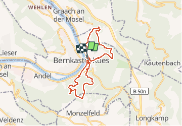
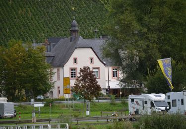
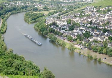
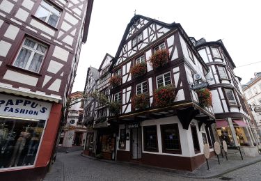
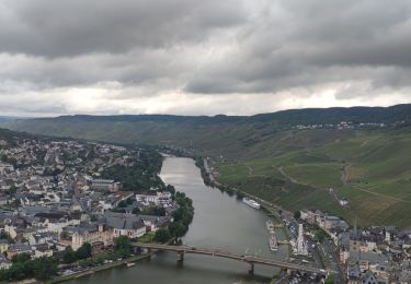
Trail Walking of 14.1 km to be discovered at Rhineland-Palatinate, Landkreis Bernkastel-Wittlich, Bernkastel-Kues. This trail is proposed by rvapeldo.
Description
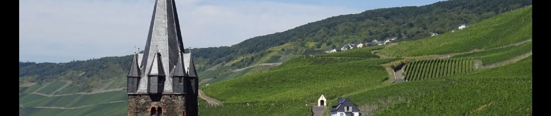
Double boucle au départ de Bernkastel. Au coeur d’un des plus grand vignoble de la Moselle Allemande, surtout du raisin Riesling. Avec un passage au chateau de Landshut.
Positioning
Country:
Germany
Region :
Rhineland-Palatinate
Department/Province :
Landkreis Bernkastel-Wittlich
Municipality :
Bernkastel-Kues
Location:
Unknown
Start:(Dec)
Start:(UTM)
361737 ; 5531158 (32U) N.
Comments
Trails nearby
![Trail On foot Bernkastel-Kues - Moselsteig Seitensprung Bernkasteler Bärensteig - Photo](https://media.geolcdn.com/t/375/260/7fd007be-cf57-41d6-aef3-4b117491e3df.jpeg&format=jpg&maxdim=2)
![On foot On foot](https://static1.geolcdn.com/sitytour/trail-icons/100.png)
Moselsteig Seitensprung Bernkasteler Bärensteig
On foot
Easy
Bernkastel-Kues,
Rhineland-Palatinate,
Landkreis Bernkastel-Wittlich,
Germany
![](/images/other/stat-length.png)
6.3 km | 10.5 km-effort
2h 23min
![](https://static1.geolcdn.com/siteimages/upload/files/16400158638029165_repeat_loop_refresh_sync_direction_icon.png)
Yes
![Trail On foot Mülheim an der Mosel - Ponoramaweg - Photo](https://media.geolcdn.com/t/375/260/8ee021a1-10e3-4c58-8032-bbec2df5a624.jpeg&format=jpg&maxdim=2)
![On foot On foot](https://static1.geolcdn.com/sitytour/trail-icons/100.png)
Ponoramaweg
On foot
Easy
Mülheim an der Mosel,
Rhineland-Palatinate,
Landkreis Bernkastel-Wittlich,
Germany
![](/images/other/stat-length.png)
10.2 km | 13.1 km-effort
2h 58min
![](https://static1.geolcdn.com/siteimages/upload/files/16400158638029165_repeat_loop_refresh_sync_direction_icon.png)
Yes
![Trail On foot Graach an der Mosel - Himmelreich Wanderweg - Photo](https://media.geolcdn.com/t/375/260/9a2018db-0271-4a75-a325-1dba57651056.jpeg&format=jpg&maxdim=2)
![On foot On foot](https://static1.geolcdn.com/sitytour/trail-icons/100.png)
Himmelreich Wanderweg
On foot
Easy
Graach an der Mosel,
Rhineland-Palatinate,
Landkreis Bernkastel-Wittlich,
Germany
![](/images/other/stat-length.png)
6.5 km | 8.9 km-effort
2h 1min
![](https://static1.geolcdn.com/siteimages/upload/files/16400158638029165_repeat_loop_refresh_sync_direction_icon.png)
Yes
![Trail On foot Zeltingen-Rachtig - Deutschherrenweg - Photo](https://media.geolcdn.com/t/375/260/bcc61c58-051e-4deb-81d2-9b2813021b78.jpeg&format=jpg&maxdim=2)
![On foot On foot](https://static1.geolcdn.com/sitytour/trail-icons/100.png)
Deutschherrenweg
On foot
Easy
Zeltingen-Rachtig,
Rhineland-Palatinate,
Landkreis Bernkastel-Wittlich,
Germany
![](/images/other/stat-length.png)
6.5 km | 8.7 km-effort
1h 59min
![](https://static1.geolcdn.com/siteimages/upload/files/16400158638029165_repeat_loop_refresh_sync_direction_icon.png)
Yes
![Trail On foot Bernkastel-Kues - Burg-Olymp-Tour - Photo](https://media.geolcdn.com/t/375/260/e86d356a-6b4f-4ee9-ba9b-aab206be3c9b.jpeg&format=jpg&maxdim=2)
![On foot On foot](https://static1.geolcdn.com/sitytour/trail-icons/100.png)
Burg-Olymp-Tour
On foot
Easy
Bernkastel-Kues,
Rhineland-Palatinate,
Landkreis Bernkastel-Wittlich,
Germany
![](/images/other/stat-length.png)
7.1 km | 11.5 km-effort
2h 36min
![](https://static1.geolcdn.com/siteimages/upload/files/16400158638029165_repeat_loop_refresh_sync_direction_icon.png)
Yes
![Trail On foot Bernkastel-Kues - Maria-Zill Panoramaweg - Photo](https://media.geolcdn.com/t/375/260/15bb359e-f5c6-4839-a503-d329f9327324.jpeg&format=jpg&maxdim=2)
![On foot On foot](https://static1.geolcdn.com/sitytour/trail-icons/100.png)
Maria-Zill Panoramaweg
On foot
Easy
Bernkastel-Kues,
Rhineland-Palatinate,
Landkreis Bernkastel-Wittlich,
Germany
![](/images/other/stat-length.png)
6.1 km | 10.4 km-effort
2h 21min
![](https://static1.geolcdn.com/siteimages/upload/files/16400158638029165_repeat_loop_refresh_sync_direction_icon.png)
Yes
![Trail On foot Bernkastel-Kues - Bernkasteler Schweiz - Photo](https://media.geolcdn.com/t/375/260/f0b6aaab-f515-41c9-b98a-f422750f297b.jpeg&format=jpg&maxdim=2)
![On foot On foot](https://static1.geolcdn.com/sitytour/trail-icons/100.png)
Bernkasteler Schweiz
On foot
Easy
Bernkastel-Kues,
Rhineland-Palatinate,
Landkreis Bernkastel-Wittlich,
Germany
![](/images/other/stat-length.png)
6.6 km | 9.9 km-effort
2h 15min
![](https://static1.geolcdn.com/siteimages/upload/files/16400158638029165_repeat_loop_refresh_sync_direction_icon.png)
No
![Trail Walking Bernkastel-Kues - A travers les Vignes de la Moselle 🌿 - Photo](https://media.geolcdn.com/t/375/260/d1aede8a-808e-4c6e-be98-4f2c9099a0d8.jpg&format=jpg&maxdim=2)
![Walking Walking](https://static1.geolcdn.com/sitytour/trail-icons/101.png)
A travers les Vignes de la Moselle 🌿
Walking
Medium
Bernkastel-Kues,
Rhineland-Palatinate,
Landkreis Bernkastel-Wittlich,
Germany
![](/images/other/stat-length.png)
16.1 km | 24 km-effort
5h 25min
![](https://static1.geolcdn.com/siteimages/upload/files/16400158638029165_repeat_loop_refresh_sync_direction_icon.png)
No
![Trail On foot Veldenz - Moselsteig Seitensprung : Graf Georg Johannes Weg - Photo](https://media.geolcdn.com/t/375/260/8ee021a1-10e3-4c58-8032-bbec2df5a624.jpeg&format=jpg&maxdim=2)
![On foot On foot](https://static1.geolcdn.com/sitytour/trail-icons/100.png)
Moselsteig Seitensprung : Graf Georg Johannes Weg
On foot
Medium
Veldenz,
Rhineland-Palatinate,
Landkreis Bernkastel-Wittlich,
Germany
![](/images/other/stat-length.png)
13.6 km | 21 km-effort
4h 41min
![](https://static1.geolcdn.com/siteimages/upload/files/16400158638029165_repeat_loop_refresh_sync_direction_icon.png)
Yes