Trail Walking Vallorbe - dent de Vaulion et mont d'or - Photo
 BM25
BM25

User

© OpenStreetMap contributors
Length
Length
28 km
Max alt
Max alt
1470 m
Uphill gradient
Uphill gradient
1523 m
Km-Effort
Km-Effort  
47 km
Min alt
Min alt
746 m
Downhill gradient
Downhill gradient
1269 m
Boucle
Boucle
No
Creation date :
2019-07-09 06:18:00.724
Updated on :
2019-07-09 14:11:20.029

(0 Reviews)

Walking
Walking
7h25
Difficulty : Medium

Scan this QR Code to open this trail in the SityTrail application

FREE GPS app for hiking

Logo SityTrail SityTrail

IGN / Geographical institutes

Download SityTrail from the App Store Download SityTrail from Google Play

Logo SityTrail SityTrail World

The world is yours!

Download SityTrail from the App Store Download SityTrail from Google Play Download SityTrail on Huawei AppGallery

About

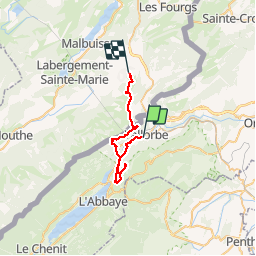
Trail Walking of 28 km to be discovered at Vaud, District du Jura-Nord vaudois, Vallorbe. This trail is proposed by BM25.

Description

depuis Vallorbe ,ascension dent de Vaulion,  retour par la petite échelle, cabane du CAS  puis sommet Mont d'or par les crêtes, et retour station Metabief.

Elevation profile

Positioning

Country:
Switzerland
Region :
Vaud
Department/Province :
District du Jura-Nord vaudois
Municipality :
Vallorbe
Location:
Unknown
Start:(UTM)
299321 ; 5176214 (32T) N.

Trails nearby

Trail Mountain bike Vallorbe - Le Suchet - Photo
Mountain bike
GUIDE+

Mountain bike

Very easy
(1)
Vallorbe, Vaud, District du Jura-Nord vaudois, Switzerland
35 km | 53 km-effort
14h 41min
Yes
Trail On foot Vallorbe - Mont d'Orzeires - Le Pont Gare - Photo
On foot
PRO

On foot

Easy
Vallorbe, Vaud, District du Jura-Nord vaudois, Switzerland
3.2 km | 4.4 km-effort
59min
No
Trail On foot Ballaigues - Ballaigues-Vallorbe - Photo
On foot
PRO

On foot

Easy
Ballaigues, Vaud, District du Jura-Nord vaudois, Switzerland
5.1 km | 6.3 km-effort
1h 25min
No
Trail On foot Vallorbe - Saigne Geret-Les Revines - Photo
On foot
PRO

On foot

Easy
Vallorbe, Vaud, District du Jura-Nord vaudois, Switzerland
3.5 km | 4.1 km-effort
56min
No
Trail On foot Juriens - TP Mollendruz - Romainmôtie - Photo
On foot
PRO

On foot

Easy
Juriens, Vaud, District du Jura-Nord vaudois, Switzerland
7.8 km | 11.6 km-effort
2h 38min
No
Trail Walking L'Abbaye - La Dent de Vaulion - Photo
Walking
drarep

Walking

Very difficult
(1)
L'Abbaye, Vaud, District du Jura-Nord vaudois, Switzerland
14.6 km | 22 km-effort
4h 31min
Yes
Trail Walking Rochejean - Mont d'or  - Photo
Walking
eltonnermou

Walking

Easy
Rochejean, Bourgogne-Franche-Comté, Doubs, France
11.9 km | 17.5 km-effort
4h 53min
Yes
Trail Walking Jougne - La Jougnena - Photo
Walking
daniellebou

Walking

Very difficult
(1)
Jougne, Bourgogne-Franche-Comté, Doubs, France
17.7 km | 24 km-effort
5h 32min
Yes
Trail Snowshoes L'Abbaye - Le Pont dent de Vaulion Suisse - Photo
Snowshoes
janussity

Snowshoes

Very easy
L'Abbaye, Vaud, District du Jura-Nord vaudois, Switzerland
16.1 km | 24 km-effort
4h 20min
Yes


Close
My subscriptions