Trail Mountain bike Taninges - VTT(74)- Taninges - Verchaix - Sixt - Fer à Cheval - Photo

VTT(74)- Taninges - Verchaix - Sixt - Fer à Cheval

 HG74250
HG74250

User

© OpenStreetMap contributors
Length
Length
36 km
Max alt
Max alt
867 m
Uphill gradient
Uphill gradient
552 m
Km-Effort
Km-Effort  
43 km
Min alt
Min alt
622 m
Downhill gradient
Downhill gradient
505 m
Boucle
Boucle
No
Creation date :
2019-07-07 18:54:39.88
Updated on :
2020-01-04 17:10:48.184

(0 Reviews)

Mountain bike
Mountain bike
2h50
Difficulty : Very difficult

Scan this QR Code to open this trail in the SityTrail application

FREE GPS app for hiking

Logo SityTrail SityTrail

IGN / Geographical institutes

Download SityTrail from the App Store Download SityTrail from Google Play

Logo SityTrail SityTrail World

The world is yours!

Download SityTrail from the App Store Download SityTrail from Google Play Download SityTrail on Huawei AppGallery

About

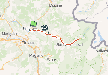
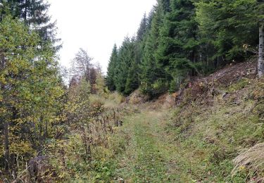
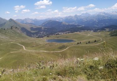
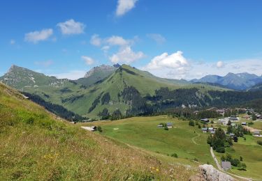
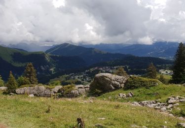
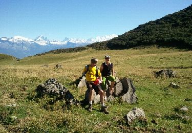
Trail Mountain bike of 36 km to be discovered at Auvergne-Rhône-Alpes, Upper Savoy, Taninges. This trail is proposed by HG74250.

Description

Dimanche 7 Juillet 2019 - Seul.
Hier tour de 35 km Tour du Vouan

Elevation profile

Positioning

Country:
France
Region :
Auvergne-Rhône-Alpes
Department/Province :
Upper Savoy
Municipality :
Taninges
Location:
Unknown
Start:(UTM)
313754 ; 5107944 (32T) N.

Trails nearby

Trail Cycle Scionzier - Vallée de l'Arve et du Giffre - Cluses - Photo
Cycle
tracegps

Cycle

Difficult
(1)
Scionzier, Auvergne-Rhône-Alpes, Upper Savoy, France
72 km | 86 km-effort
3h 0min
Yes
Trail Walking Mieussy - 09-05-2022 Boucle Mieussy - Le Jourdy -Chapelle Saint Gras - Photo
Walking
GUIDE
Kargil

Walking

Medium
Mieussy, Auvergne-Rhône-Alpes, Upper Savoy, France
11.9 km | 23 km-effort
3h 32min
Yes
Trail Walking Taninges - Promenade de la cascade - Photo
Walking
so.duchateau

Walking

Medium
Taninges, Auvergne-Rhône-Alpes, Upper Savoy, France
11.1 km | 17.3 km-effort
3h 11min
Yes
Trail Walking Arâches-la-Frasse - La Grasse les granges, l'Artoche, la combe, les sommaires, retour par la Presse, la mouille - Photo
Walking
reneperrin

Walking

Medium
Arâches-la-Frasse, Auvergne-Rhône-Alpes, Upper Savoy, France
8.6 km | 15.6 km-effort
3h 20min
Yes
Trail Walking Taninges - Pic de Marcelly - Photo
Walking
stihy

Walking

Medium
Taninges, Auvergne-Rhône-Alpes, Upper Savoy, France
10.2 km | 19 km-effort
4h 16min
Yes
Trail Walking Taninges - le pic de marcelly - Photo
Walking
Vero7684

Walking

Medium
Taninges, Auvergne-Rhône-Alpes, Upper Savoy, France
8.1 km | 15.6 km-effort
3h 57min
Yes
Trail Walking Taninges - le haut Fleury - Photo
Walking
Cricounet84

Walking

Medium
Taninges, Auvergne-Rhône-Alpes, Upper Savoy, France
10.5 km | 18.3 km-effort
3h 17min
Yes
Trail Walking Taninges - le lac du roy - Photo
Walking
Cricounet84

Walking

Medium
Taninges, Auvergne-Rhône-Alpes, Upper Savoy, France
9.2 km | 13.5 km-effort
3h 33min
Yes
Trail Walking Taninges - lac roy  - Photo
Walking
mireillealpes

Walking

Very easy
Taninges, Auvergne-Rhône-Alpes, Upper Savoy, France
7.4 km | 11.4 km-effort
2h 2min
Yes


Close
My subscriptions