![](/images/other/stat-length.png)
![Trail Walking Villarodin-Bourget - 0rgère - Photo](https://media.geolcdn.com/t/1900/400/b838c432-1435-44d0-8073-3bf22757ea4a.jpg&format=pjpeg&maxdim=2)
0rgère
phdsyn
User
![Length](/images/other/stat-length.png)
![Max alt](https://static1.geolcdn.com/siteimages/upload/files/1508320355ic_sort_altitude_max_24dp.png)
![Uphill gradient](https://static1.geolcdn.com/siteimages/upload/files/1508320355ic_sort_den_pos_24dp.png)
![Km-Effort](/images/other/stat-length.png)
![Min alt](https://static1.geolcdn.com/siteimages/upload/files/1508320355ic_sort_altitude_min_24dp.png)
![Downhill gradient](https://static1.geolcdn.com/siteimages/upload/files/1508320355ic_sort_den_neg_24dp.png)
![Boucle](https://static1.geolcdn.com/siteimages/upload/files/16400158638029165_repeat_loop_refresh_sync_direction_icon.png)
![Walking](https://static1.geolcdn.com/sitytour/trail-icons/101.png)
3h13
Difficulty : Very easy
![Scan this QR Code to open this trail in the SityTrail application](https://capi.geolives.com/qq0zvz2zws4bq2lad0pu/sitytour/trails/2133253/qr.png?size=200)
FREE GPS app for hiking
About
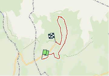
Trail Walking of 5.7 km to be discovered at Auvergne-Rhône-Alpes, Savoy, Villarodin-Bourget. This trail is proposed by phdsyn.
Description
Dans le Parc national de la Vanoise, ce sentier vous propose, en famille, grâce à son mobilier et ses outils d'interprétation jalonnant le parcours, une manière ludique de découvrir le patrimoine naturel et historique du vallon..
Ce parcours vous propose une boucle plus escarpée, mais sans difficulté, pour rejoindre le refuge.
L'accès de ce vallon est d'un accès facile en particulier pour les déficients visuels et moteurs.
Positioning
Comments
Trails nearby
![Trail Walking Avrieux - Col du Barbier et télégraphe - Photo](https://media.geolcdn.com/t/375/260/6ccb7b01-5841-4073-984c-e7b3df5e0f0f.jpg&format=jpg&maxdim=2)
![Walking Walking](https://static1.geolcdn.com/sitytour/trail-icons/101.png)
Walking
![](/images/other/stat-length.png)
![](https://static1.geolcdn.com/siteimages/upload/files/16400158638029165_repeat_loop_refresh_sync_direction_icon.png)
![Trail Touring skiing Villarodin-Bourget - passage de la belle Plinier Nord - Photo](https://media.geolcdn.com/t/375/260/24fce6f9-d37e-4224-8f2c-4b95f0071df0.jpg&format=jpg&maxdim=2)
![Touring skiing Touring skiing](https://static1.geolcdn.com/sitytour/trail-icons/503.png)
Touring skiing
![](/images/other/stat-length.png)
![](https://static1.geolcdn.com/siteimages/upload/files/16400158638029165_repeat_loop_refresh_sync_direction_icon.png)
![Trail On foot Villarodin-Bourget - Vallon de l'Orgère - Photo](https://media.geolcdn.com/t/375/260/7808cf41-72f7-4322-acd1-b2150517cd1e.jpeg&format=jpg&maxdim=2)
![On foot On foot](https://static1.geolcdn.com/sitytour/trail-icons/100.png)
On foot
![](/images/other/stat-length.png)
![](https://static1.geolcdn.com/siteimages/upload/files/16400158638029165_repeat_loop_refresh_sync_direction_icon.png)
![Trail Touring skiing Saint-André - Tête noire en boucle - Photo](https://media.geolcdn.com/t/375/260/0bb3542f-e5da-45e0-a1b0-86c9b0c52fb3.jpg&format=jpg&maxdim=2)
![Touring skiing Touring skiing](https://static1.geolcdn.com/sitytour/trail-icons/503.png)
Touring skiing
![](/images/other/stat-length.png)
![](https://static1.geolcdn.com/siteimages/upload/files/16400158638029165_repeat_loop_refresh_sync_direction_icon.png)
![Trail Snowshoes Saint-André - l Orgere - Photo](https://media.geolcdn.com/t/375/260/68f383ec-1a93-4bdd-ac56-2814b85cf93a.jpg&format=jpg&maxdim=2)
![Snowshoes Snowshoes](https://static1.geolcdn.com/sitytour/trail-icons/504.png)
Snowshoes
![](/images/other/stat-length.png)
![](https://static1.geolcdn.com/siteimages/upload/files/16400158638029165_repeat_loop_refresh_sync_direction_icon.png)
![Trail Walking Aussois - Le tour du glacier de la Vanoise - Photo](https://media.geolcdn.com/t/375/260/ext.jpg?maxdim=2&url=https%3A%2F%2Fstatic1.geolcdn.com%2Fsiteimages%2Fupload%2Ffiles%2F1553511878bg_sport_marche.png)
![Walking Walking](https://static1.geolcdn.com/sitytour/trail-icons/101.png)
Walking
![](/images/other/stat-length.png)
![](https://static1.geolcdn.com/siteimages/upload/files/16400158638029165_repeat_loop_refresh_sync_direction_icon.png)
![Trail Walking Aussois - 2024 les refuges d'Aussois - Photo](https://media.geolcdn.com/t/375/260/5f79f632-2b24-40cf-9ccf-ddf5c76d140d.jpg&format=jpg&maxdim=2)
![Walking Walking](https://static1.geolcdn.com/sitytour/trail-icons/101.png)
Walking
![](/images/other/stat-length.png)
![](https://static1.geolcdn.com/siteimages/upload/files/16400158638029165_repeat_loop_refresh_sync_direction_icon.png)
![Trail Walking Villarodin-Bourget - La Norma / Télécabine Melezet / Valfréjus - Photo](https://media.geolcdn.com/t/375/260/588a4be4-ac90-41f5-b3fb-9c859be949e5.jpg&format=jpg&maxdim=2)
![Walking Walking](https://static1.geolcdn.com/sitytour/trail-icons/101.png)
Walking
![](/images/other/stat-length.png)
![](https://static1.geolcdn.com/siteimages/upload/files/16400158638029165_repeat_loop_refresh_sync_direction_icon.png)
![Trail sport Fourneaux - Modane - Fort du Sapey AR - Photo](https://media.geolcdn.com/t/375/260/b1ec93f7-a43e-447d-89da-a697825d70af.jpg&format=jpg&maxdim=2)
sport
![](/images/other/stat-length.png)
![](https://static1.geolcdn.com/siteimages/upload/files/16400158638029165_repeat_loop_refresh_sync_direction_icon.png)