![](/images/other/stat-length.png)
![Trail Walking Bras - Bras - Photo](https://media.geolcdn.com/t/1900/400/ext.pjpeg?maxdim=2&url=https%3A%2F%2Fstatic1.geolcdn.com%2Fsiteimages%2Fupload%2Ffiles%2F1553511878bg_sport_marche.png)
Bras
brunotrail05
User
![Length](/images/other/stat-length.png)
Length
7.8 km
![Max alt](https://static1.geolcdn.com/siteimages/upload/files/1508320355ic_sort_altitude_max_24dp.png)
Max alt
329 m
![Uphill gradient](https://static1.geolcdn.com/siteimages/upload/files/1508320355ic_sort_den_pos_24dp.png)
Uphill gradient
133 m
![Km-Effort](/images/other/stat-length.png)
Km-Effort
9.6 km
![Min alt](https://static1.geolcdn.com/siteimages/upload/files/1508320355ic_sort_altitude_min_24dp.png)
Min alt
251 m
![Downhill gradient](https://static1.geolcdn.com/siteimages/upload/files/1508320355ic_sort_den_neg_24dp.png)
Downhill gradient
139 m
![Boucle](https://static1.geolcdn.com/siteimages/upload/files/16400158638029165_repeat_loop_refresh_sync_direction_icon.png)
Boucle
Yes
Creation date :
2014-12-10 00:00:00.0
Updated on :
2014-12-10 00:00:00.0
![Walking](https://static1.geolcdn.com/sitytour/trail-icons/101.png)
2h07
Difficulty : Easy
![Scan this QR Code to open this trail in the SityTrail application](https://capi.geolives.com/qq0zvz2zws4bq2lad0pu/sitytour/trails/212956/qr.png?size=200)
FREE GPS app for hiking
About
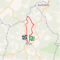
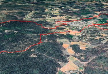
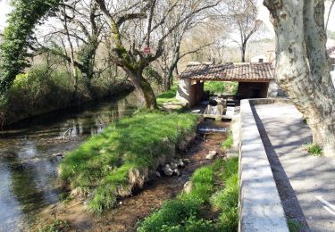
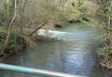
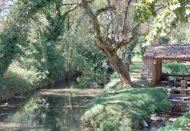
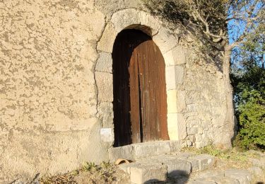
Trail Walking of 7.8 km to be discovered at Provence-Alpes-Côte d'Azur, Var, Bras. This trail is proposed by brunotrail05.
Description
Randonnée pedestre à Bras (facile) de 7.8 km, durant 2h30 avec un dénivelé de 160m. Départ Place Sadi Carnot - balisage jaune puis rouge et blanc
Positioning
Country:
France
Region :
Provence-Alpes-Côte d'Azur
Department/Province :
Var
Municipality :
Bras
Location:
Unknown
Start:(Dec)
Start:(UTM)
738899 ; 4817451 (31T) N.
Comments
Trails nearby
![Trail Walking Bras - Chutes du tombereau - Photo](https://media.geolcdn.com/t/375/260/ext.jpg?maxdim=2&url=https%3A%2F%2Fmedia.geolcdn.com%2Ff%2F3ed533da-12d6-4a04-9744-f8536921f316.jpg)
![Walking Walking](https://static1.geolcdn.com/sitytour/trail-icons/101.png)
Chutes du tombereau
Walking
Easy
(1)
Bras,
Provence-Alpes-Côte d'Azur,
Var,
France
![](/images/other/stat-length.png)
11.1 km | 13.6 km-effort
2h 42min
![](https://static1.geolcdn.com/siteimages/upload/files/16400158638029165_repeat_loop_refresh_sync_direction_icon.png)
Yes
![Trail sport Bras - Bras Martine - Photo](https://media.geolcdn.com/t/375/260/ext.jpg?maxdim=2&url=https%3A%2F%2Fmedia.geolcdn.com%2Ff%2F92424973-da8f-45dd-b870-2b8efea2ae3b.jpg)
Bras Martine
sport
Very easy
Bras,
Provence-Alpes-Côte d'Azur,
Var,
France
![](/images/other/stat-length.png)
12.3 km | 15.6 km-effort
Unknown
![](https://static1.geolcdn.com/siteimages/upload/files/16400158638029165_repeat_loop_refresh_sync_direction_icon.png)
Yes
![Trail Walking Bras - Bras jeudi 10/02/2022 Martine - Photo](https://media.geolcdn.com/t/375/260/ext.jpg?maxdim=2&url=https%3A%2F%2Fmedia.geolcdn.com%2Ff%2Fb21c62da-7a83-4fcf-a674-3504e8c67f06.jpg)
![Walking Walking](https://static1.geolcdn.com/sitytour/trail-icons/101.png)
Bras jeudi 10/02/2022 Martine
Walking
Difficult
Bras,
Provence-Alpes-Côte d'Azur,
Var,
France
![](/images/other/stat-length.png)
15.1 km | 18.3 km-effort
4h 24min
![](https://static1.geolcdn.com/siteimages/upload/files/16400158638029165_repeat_loop_refresh_sync_direction_icon.png)
No
![Trail Walking Bras - Bras - Photo](https://media.geolcdn.com/t/375/260/ext.jpg?maxdim=2&url=https%3A%2F%2Fmedia.geolcdn.com%2Ff%2Fa7a6d44b-4aa6-4c28-978c-deb3e4b9a501.jpg)
![Walking Walking](https://static1.geolcdn.com/sitytour/trail-icons/101.png)
Bras
Walking
Easy
(1)
Bras,
Provence-Alpes-Côte d'Azur,
Var,
France
![](/images/other/stat-length.png)
15 km | 18.3 km-effort
3h 33min
![](https://static1.geolcdn.com/siteimages/upload/files/16400158638029165_repeat_loop_refresh_sync_direction_icon.png)
Yes
![Trail Walking Bras - 20190414 reco partielle Bras Le Tombereau - Photo](https://media.geolcdn.com/t/375/260/ext.jpg?maxdim=2&url=https%3A%2F%2Fmedia.geolcdn.com%2Ff%2Faa3c4189-1fb5-4f4f-b81a-5f04b149b2b5.jpg)
![Walking Walking](https://static1.geolcdn.com/sitytour/trail-icons/101.png)
20190414 reco partielle Bras Le Tombereau
Walking
Easy
Bras,
Provence-Alpes-Côte d'Azur,
Var,
France
![](/images/other/stat-length.png)
15.5 km | 18.7 km-effort
4h 25min
![](https://static1.geolcdn.com/siteimages/upload/files/16400158638029165_repeat_loop_refresh_sync_direction_icon.png)
No
![Trail Walking Bras - Bras reco - Photo](https://media.geolcdn.com/t/375/260/ext.jpg?maxdim=2&url=https%3A%2F%2Fmedia.geolcdn.com%2Ff%2Fd49c88bf-b8e3-49d9-a838-2bb1359ee89b.jpg)
![Walking Walking](https://static1.geolcdn.com/sitytour/trail-icons/101.png)
Bras reco
Walking
Easy
Bras,
Provence-Alpes-Côte d'Azur,
Var,
France
![](/images/other/stat-length.png)
14 km | 17.2 km-effort
7h 43min
![](https://static1.geolcdn.com/siteimages/upload/files/16400158638029165_repeat_loop_refresh_sync_direction_icon.png)
Yes
![Trail Walking Bras - 2021 04 01 brue auriac_pont de sumian@argens - Photo](https://media.geolcdn.com/t/375/260/ext.jpg?maxdim=2&url=https%3A%2F%2Fmedia.geolcdn.com%2Ff%2F68c811f0-8b76-40b1-a8e9-2df0ed2c11bb.jpg)
![Walking Walking](https://static1.geolcdn.com/sitytour/trail-icons/101.png)
2021 04 01 brue auriac_pont de sumian@argens
Walking
Very easy
Bras,
Provence-Alpes-Côte d'Azur,
Var,
France
![](/images/other/stat-length.png)
7.8 km | 9.5 km-effort
6h 53min
![](https://static1.geolcdn.com/siteimages/upload/files/16400158638029165_repeat_loop_refresh_sync_direction_icon.png)
Yes
![Trail Walking Bras - bras - Photo](https://media.geolcdn.com/t/375/260/ext.jpg?maxdim=2&url=https%3A%2F%2Fmedia.geolcdn.com%2Ff%2F7b543651-c942-4131-8b39-e4a53c86e438.jpg)
![Walking Walking](https://static1.geolcdn.com/sitytour/trail-icons/101.png)
bras
Walking
Medium
Bras,
Provence-Alpes-Côte d'Azur,
Var,
France
![](/images/other/stat-length.png)
15.7 km | 18.9 km-effort
5h 15min
![](https://static1.geolcdn.com/siteimages/upload/files/16400158638029165_repeat_loop_refresh_sync_direction_icon.png)
Yes
![Trail Walking Le Val - 20200311 Le Val rando réelle - Photo](https://media.geolcdn.com/t/375/260/ext.jpg?maxdim=2&url=https%3A%2F%2Fmedia.geolcdn.com%2Ff%2F087a27c2-e70e-4cae-97e4-a3ca0d97a444.jpg)
![Walking Walking](https://static1.geolcdn.com/sitytour/trail-icons/101.png)
20200311 Le Val rando réelle
Walking
Medium
Le Val,
Provence-Alpes-Côte d'Azur,
Var,
France
![](/images/other/stat-length.png)
16 km | 22 km-effort
6h 18min
![](https://static1.geolcdn.com/siteimages/upload/files/16400158638029165_repeat_loop_refresh_sync_direction_icon.png)
Yes
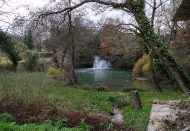
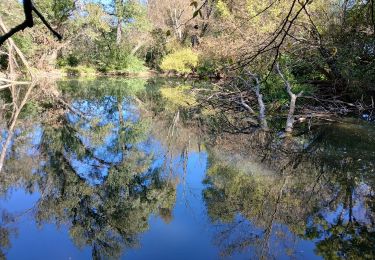
jolie ballade dans la campagne, il manque juste un point de vue