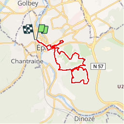
![](/images/other/stat-length.png)
![Trail Walking Épinal - Epinal sentier des dix, - Photo](https://media.geolcdn.com/t/1900/400/ext.pjpeg?maxdim=2&url=https%3A%2F%2Fstatic1.geolcdn.com%2Fsiteimages%2Fupload%2Ffiles%2F1553511878bg_sport_marche.png)
Epinal sentier des dix,
joelclaudel
User
![Length](/images/other/stat-length.png)
Length
16.1 km
![Max alt](https://static1.geolcdn.com/siteimages/upload/files/1508320355ic_sort_altitude_max_24dp.png)
Max alt
467 m
![Uphill gradient](https://static1.geolcdn.com/siteimages/upload/files/1508320355ic_sort_den_pos_24dp.png)
Uphill gradient
382 m
![Km-Effort](/images/other/stat-length.png)
Km-Effort
21 km
![Min alt](https://static1.geolcdn.com/siteimages/upload/files/1508320355ic_sort_altitude_min_24dp.png)
Min alt
320 m
![Downhill gradient](https://static1.geolcdn.com/siteimages/upload/files/1508320355ic_sort_den_neg_24dp.png)
Downhill gradient
383 m
![Boucle](https://static1.geolcdn.com/siteimages/upload/files/16400158638029165_repeat_loop_refresh_sync_direction_icon.png)
Boucle
Yes
Creation date :
2014-12-10 00:00:00.0
Updated on :
2014-12-10 00:00:00.0
![Walking](https://static1.geolcdn.com/sitytour/trail-icons/101.png)
4h25
Difficulty : Medium
![Scan this QR Code to open this trail in the SityTrail application](https://capi.geolives.com/qq0zvz2zws4bq2lad0pu/sitytour/trails/212509/qr.png?size=200)
FREE GPS app for hiking
About
Trail Walking of 16.1 km to be discovered at Grand Est, Vosges, Épinal. This trail is proposed by joelclaudel.
Description
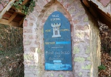
Départ de la gare jusqu'à la rue des Soupirs, panneau de départ du circuit (anneau vert), le Mont Carmel, la Fontaine Guery,la Croix des Pestiférés et pour terminer la rando, montée au château,point de vue et parc animalier
Positioning
Country:
France
Region :
Grand Est
Department/Province :
Vosges
Municipality :
Épinal
Location:
Unknown
Start:(Dec)
Start:(UTM)
309913 ; 5339250 (32U) N.
Comments
Trails nearby
![Trail sport Épinal - Golbey - Photo](https://media.geolcdn.com/t/375/260/ext.jpg?maxdim=2&url=https%3A%2F%2Fsecurestorage.geolives.com%2Fsitytour%2Ftrail-bg%2Fdefault.jpg)
![Trail Walking Épinal - Epinal - Photo](https://media.geolcdn.com/t/375/260/940302e4-e305-4d1c-a286-7e159c6cde8b.jpg&format=jpg&maxdim=2)
![Walking Walking](https://static1.geolcdn.com/sitytour/trail-icons/101.png)
![Trail Walking Épinal - humbertois les ,2lacs - Photo](https://media.geolcdn.com/t/375/260/c469247b-9bb0-491c-9204-6b2729eb7b0d.jpg&format=jpg&maxdim=2)
![Walking Walking](https://static1.geolcdn.com/sitytour/trail-icons/101.png)
humbertois les ,2lacs
Walking
Medium
Épinal,
Grand Est,
Vosges,
France
![](/images/other/stat-length.png)
7.3 km | 8.9 km-effort
1h 55min
![](https://static1.geolcdn.com/siteimages/upload/files/16400158638029165_repeat_loop_refresh_sync_direction_icon.png)
Yes
![Trail On foot Épinal - uzefaing 2 la grenouille - Photo](https://media.geolcdn.com/t/375/260/bbcf75ae-233b-421b-ab5d-c893e05cb26f.jpg&format=jpg&maxdim=2)
![On foot On foot](https://static1.geolcdn.com/sitytour/trail-icons/100.png)
uzefaing 2 la grenouille
On foot
Medium
Épinal,
Grand Est,
Vosges,
France
![](/images/other/stat-length.png)
18.1 km | 23 km-effort
5h 17min
![](https://static1.geolcdn.com/siteimages/upload/files/16400158638029165_repeat_loop_refresh_sync_direction_icon.png)
Yes
![Trail Road bike Épinal - epinal florémont bouxières - Photo](https://media.geolcdn.com/t/375/260/ext.jpg?maxdim=2&url=https%3A%2F%2Fstatic1.geolcdn.com%2Fsiteimages%2Fupload%2Ffiles%2F1524743154velo.jpg)
![Road bike Road bike](https://static1.geolcdn.com/sitytour/trail-icons/201.png)
epinal florémont bouxières
Road bike
Medium
(1)
Épinal,
Grand Est,
Vosges,
France
![](/images/other/stat-length.png)
93 km | 110 km-effort
6h 26min
![](https://static1.geolcdn.com/siteimages/upload/files/16400158638029165_repeat_loop_refresh_sync_direction_icon.png)
Yes
![Trail Walking Épinal - ste Barbe - Photo](https://media.geolcdn.com/t/375/260/ext.jpg?maxdim=2&url=https%3A%2F%2Fservices.sitytrail.com%2FGeolivesWS%2FDownloadMedia.ashx%3FTrailID%3D1071507%26Media%3Dfix__20181114151145.jpg)
![Walking Walking](https://static1.geolcdn.com/sitytour/trail-icons/101.png)
![Trail Walking Épinal - 2016 03 22 - Photo](https://media.geolcdn.com/t/375/260/ext.jpg?maxdim=2&url=https%3A%2F%2Fservices.sitytrail.com%2FGeolivesWS%2FDownloadMedia.ashx%3FTrailID%3D542217%26Media%3Dfix__20160322163522.jpg)
![Walking Walking](https://static1.geolcdn.com/sitytour/trail-icons/101.png)
![Trail Other activity Épinal - Grand Est - Ligne 18 - Epinal St Diè - Photo](https://media.geolcdn.com/t/375/260/ext.jpg?maxdim=2&url=https%3A%2F%2Fservices.sitytrail.com%2FGeolivesWS%2FDownloadMedia.ashx%3FTrailID%3D449149%26Media%3D79b8c567-20fe-4c86-8015-3c376b29db07.jpg)
![Other activity Other activity](https://static1.geolcdn.com/sitytour/trail-icons/900.png)
Grand Est - Ligne 18 - Epinal St Diè
Other activity
Very easy
Épinal,
Grand Est,
Vosges,
France
![](/images/other/stat-length.png)
61 km | 68 km-effort
5min
![](https://static1.geolcdn.com/siteimages/upload/files/16400158638029165_repeat_loop_refresh_sync_direction_icon.png)
No
![Trail Other activity Épinal - Grand Est - Ligne 18,7 - Epinal Remiremont - Photo](https://media.geolcdn.com/t/375/260/ext.jpg?maxdim=2&url=https%3A%2F%2Fservices.sitytrail.com%2FGeolivesWS%2FDownloadMedia.ashx%3FTrailID%3D448459%26Media%3Da6bb1b53-2dd3-47d4-9651-180d18084675.jpg)
![Other activity Other activity](https://static1.geolcdn.com/sitytour/trail-icons/900.png)
Grand Est - Ligne 18,7 - Epinal Remiremont
Other activity
Very easy
Épinal,
Grand Est,
Vosges,
France
![](/images/other/stat-length.png)
27 km | 31 km-effort
5min
![](https://static1.geolcdn.com/siteimages/upload/files/16400158638029165_repeat_loop_refresh_sync_direction_icon.png)
No