![](/images/other/stat-length.png)
![Trail Walking Laroque-des-Albères - RP66 LAROQUE ST génis ST André SOREDE - Photo](https://media.geolcdn.com/t/1900/400/ext.pjpeg?maxdim=2&url=https%3A%2F%2Fstatic1.geolcdn.com%2Fsiteimages%2Fupload%2Ffiles%2F1553511878bg_sport_marche.png)
RP66 LAROQUE ST génis ST André SOREDE
jeff66
User
![Length](/images/other/stat-length.png)
Length
13.8 km
![Boucle](https://static1.geolcdn.com/siteimages/upload/files/16400158638029165_repeat_loop_refresh_sync_direction_icon.png)
Boucle
Yes
Creation date :
2019-06-26 05:56:16.0
Updated on :
2019-06-26 14:35:53.206
![Walking](https://static1.geolcdn.com/sitytour/trail-icons/101.png)
2h15
Difficulty : Difficult
![Scan this QR Code to open this trail in the SityTrail application](https://capi.geolives.com/qq0zvz2zws4bq2lad0pu/sitytour/trails/2124663/qr.png?size=200)
FREE GPS app for hiking
About
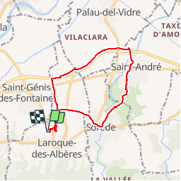
Trail Walking of 13.8 km to be discovered at Occitania, Pyrénées-Orientales, Laroque-des-Albères. This trail is proposed by jeff66.
Description
RP66 LAROQUE chemin de Tanya - SAINT GENIS - piste cyclable - SAINT ANDRE - rue de la coscolleda - SOREDE - chemins de la Gabarre - LAROQUE - le 26.06.2019
Positioning
Country:
France
Region :
Occitania
Department/Province :
Pyrénées-Orientales
Municipality :
Laroque-des-Albères
Location:
Unknown
Start:(Dec)
Start:(UTM)
494294 ; 4708459 (31T) N.
Comments
Trails nearby
![Trail Walking Laroque-des-Albères - Laroque-des-Albères, petit tour des mas - Photo](https://media.geolcdn.com/t/375/260/a38763d0-1e12-4df0-8310-6577414297bd.jpg&format=jpg&maxdim=2)
![Walking Walking](https://static1.geolcdn.com/sitytour/trail-icons/101.png)
Laroque-des-Albères, petit tour des mas
Walking
Very easy
(1)
Laroque-des-Albères,
Occitania,
Pyrénées-Orientales,
France
![](/images/other/stat-length.png)
5.4 km | 7.1 km-effort
1h 47min
![](https://static1.geolcdn.com/siteimages/upload/files/16400158638029165_repeat_loop_refresh_sync_direction_icon.png)
Yes
![Trail Walking Laroque-des-Albères - 66 LAROQUE DES ALBERES (maison) SOREDE, par pistes DFCI AL12 et 19, mas del Ca et mas Manere, Itin.16 - Photo](https://media.geolcdn.com/t/375/260/ext.jpg?maxdim=2&url=https%3A%2F%2Fservices.sitytrail.com%2FGeolivesWS%2FDownloadMedia.ashx%3FTrailID%3D585179%26Media%3D20160616145650.jpg)
![Walking Walking](https://static1.geolcdn.com/sitytour/trail-icons/101.png)
66 LAROQUE DES ALBERES (maison) SOREDE, par pistes DFCI AL12 et 19, mas del C...
Walking
Medium
(1)
Laroque-des-Albères,
Occitania,
Pyrénées-Orientales,
France
![](/images/other/stat-length.png)
11.2 km | 15.3 km-effort
2h 5min
![](https://static1.geolcdn.com/siteimages/upload/files/16400158638029165_repeat_loop_refresh_sync_direction_icon.png)
Yes
![Trail Walking Laroque-des-Albères - 66 SOREDE, LAROQUE DES ALBERES, chemins des Mas - Photo](https://media.geolcdn.com/t/375/260/ext.jpg?maxdim=2&url=https%3A%2F%2Fservices.sitytrail.com%2FGeolivesWS%2FDownloadMedia.ashx%3FTrailID%3D534699%26Media%3D20160303171633.jpg)
![Walking Walking](https://static1.geolcdn.com/sitytour/trail-icons/101.png)
66 SOREDE, LAROQUE DES ALBERES, chemins des Mas
Walking
Medium
(1)
Laroque-des-Albères,
Occitania,
Pyrénées-Orientales,
France
![](/images/other/stat-length.png)
7 km | 8.9 km-effort
1h 22min
![](https://static1.geolcdn.com/siteimages/upload/files/16400158638029165_repeat_loop_refresh_sync_direction_icon.png)
Yes
![Trail Walking Saint-André - 66 SAINT-ANDRE - SOREDE - chapelle Saint Ferreol de la Pava - Photo](https://media.geolcdn.com/t/375/260/ext.jpg?maxdim=2&url=https%3A%2F%2Fservices.sitytrail.com%2FGeolivesWS%2FDownloadMedia.ashx%3FTrailID%3D455673%26Media%3D20150807175253.jpg)
![Walking Walking](https://static1.geolcdn.com/sitytour/trail-icons/101.png)
66 SAINT-ANDRE - SOREDE - chapelle Saint Ferreol de la Pava
Walking
Medium
(1)
Saint-André,
Occitania,
Pyrénées-Orientales,
France
![](/images/other/stat-length.png)
14.2 km | 16.9 km-effort
2h 25min
![](https://static1.geolcdn.com/siteimages/upload/files/16400158638029165_repeat_loop_refresh_sync_direction_icon.png)
Yes
![Trail Walking L'Albère - SAINT-JEAN-D'ALBERE 66 - PUIG de Sant Christau par le coll de Sant Joan - Photo](https://media.geolcdn.com/t/375/260/ext.jpg?maxdim=2&url=https%3A%2F%2Fservices.sitytrail.com%2FGeolivesWS%2FDownloadMedia.ashx%3FTrailID%3D452444%26Media%3D20150731170134.jpg)
![Walking Walking](https://static1.geolcdn.com/sitytour/trail-icons/101.png)
SAINT-JEAN-D'ALBERE 66 - PUIG de Sant Christau par le coll de Sant Joan
Walking
Difficult
(1)
L'Albère,
Occitania,
Pyrénées-Orientales,
France
![](/images/other/stat-length.png)
10.1 km | 17 km-effort
2h 46min
![](https://static1.geolcdn.com/siteimages/upload/files/16400158638029165_repeat_loop_refresh_sync_direction_icon.png)
Yes
![Trail Walking Montesquieu-des-Albères - MONTESQUIEU-DES-ALBERES 66 - Les Agouillous - les chemins de l'eau dans les Albères - Photo](https://media.geolcdn.com/t/375/260/ext.jpg?maxdim=2&url=https%3A%2F%2Fservices.sitytrail.com%2FGeolivesWS%2FDownloadMedia.ashx%3FTrailID%3D451257%26Media%3D20150728182708.jpg)
![Walking Walking](https://static1.geolcdn.com/sitytour/trail-icons/101.png)
MONTESQUIEU-DES-ALBERES 66 - Les Agouillous - les chemins de l'eau dans les A...
Walking
Medium
(1)
Montesquieu-des-Albères,
Occitania,
Pyrénées-Orientales,
France
![](/images/other/stat-length.png)
12.7 km | 13.9 km-effort
2h 16min
![](https://static1.geolcdn.com/siteimages/upload/files/16400158638029165_repeat_loop_refresh_sync_direction_icon.png)
Yes
![Trail Walking Palau-del-Vidre - PALAU-DEL-VIDRE 66 - Boucle de Villeclare - promenade dans les vergers et cultures maraîchères - Photo](https://media.geolcdn.com/t/375/260/ext.jpg?maxdim=2&url=https%3A%2F%2Fservices.sitytrail.com%2FGeolivesWS%2FDownloadMedia.ashx%3FTrailID%3D426910%26Media%3D20150528155048.jpg)
![Walking Walking](https://static1.geolcdn.com/sitytour/trail-icons/101.png)
PALAU-DEL-VIDRE 66 - Boucle de Villeclare - promenade dans les vergers et cul...
Walking
Easy
(2)
Palau-del-Vidre,
Occitania,
Pyrénées-Orientales,
France
![](/images/other/stat-length.png)
7.5 km | 7.9 km-effort
1h 16min
![](https://static1.geolcdn.com/siteimages/upload/files/16400158638029165_repeat_loop_refresh_sync_direction_icon.png)
Yes
![Trail Walking Sorède - Utrera Font Miracles T - Photo](https://media.geolcdn.com/t/375/260/ext.jpg?maxdim=2&url=https%3A%2F%2Fservices.sitytrail.com%2FGeolivesWS%2FDownloadMedia.ashx%3FTrailID%3D419352%26Media%3Dfix__20150510145313.jpg)
![Walking Walking](https://static1.geolcdn.com/sitytour/trail-icons/101.png)
Utrera Font Miracles T
Walking
Medium
(1)
Sorède,
Occitania,
Pyrénées-Orientales,
France
![](/images/other/stat-length.png)
10.7 km | 17.6 km-effort
3h 50min
![](https://static1.geolcdn.com/siteimages/upload/files/16400158638029165_repeat_loop_refresh_sync_direction_icon.png)
Yes
![Trail Walking Sorède - 577. 11km sorede roc des medes - Photo](https://media.geolcdn.com/t/375/260/61f4e75a-7c25-4df1-b192-fc8eca3c7acc.jpg&format=jpg&maxdim=2)
![Walking Walking](https://static1.geolcdn.com/sitytour/trail-icons/101.png)
577. 11km sorede roc des medes
Walking
Medium
(1)
Sorède,
Occitania,
Pyrénées-Orientales,
France
![](/images/other/stat-length.png)
10.5 km | 18.2 km-effort
3h 42min
![](https://static1.geolcdn.com/siteimages/upload/files/16400158638029165_repeat_loop_refresh_sync_direction_icon.png)
Yes