![](/images/other/stat-length.png)
CC_Velay_GC_30_Ostabat-Asme_St-Jean-Pied-Port_20090414
patrickdanilo
User
![Length](/images/other/stat-length.png)
Length
23 km
![Max alt](https://static1.geolcdn.com/siteimages/upload/files/1508320355ic_sort_altitude_max_24dp.png)
Max alt
274 m
![Uphill gradient](https://static1.geolcdn.com/siteimages/upload/files/1508320355ic_sort_den_pos_24dp.png)
Uphill gradient
435 m
![Km-Effort](/images/other/stat-length.png)
Km-Effort
28 km
![Min alt](https://static1.geolcdn.com/siteimages/upload/files/1508320355ic_sort_altitude_min_24dp.png)
Min alt
137 m
![Downhill gradient](https://static1.geolcdn.com/siteimages/upload/files/1508320355ic_sort_den_neg_24dp.png)
Downhill gradient
413 m
![Boucle](https://static1.geolcdn.com/siteimages/upload/files/16400158638029165_repeat_loop_refresh_sync_direction_icon.png)
Boucle
No
Creation date :
2019-06-24 07:43:17.079
Updated on :
2022-09-19 15:01:16.969
![Walking](https://static1.geolcdn.com/sitytour/trail-icons/101.png)
6h00
Difficulty : Medium
![Scan this QR Code to open this trail in the SityTrail application](https://capi.geolives.com/qq0zvz2zws4bq2lad0pu/sitytour/trails/2122486/qr.png?size=200)
FREE GPS app for hiking
About
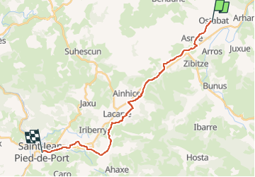
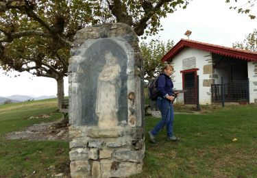
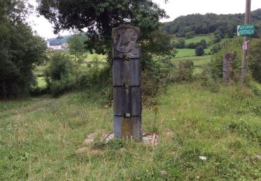
Trail Walking of 23 km to be discovered at New Aquitaine, Pyrénées-Atlantiques, Ostabat-Asme. This trail is proposed by patrickdanilo.
Description
Randonnée Marche de 23 km à découvrir à Nouvelle-Aquitaine, Pyrénées-Atlantiques, Ostabat-Asme. Cette randonnée est proposée par patrickdanilo.
Positioning
Country:
France
Region :
New Aquitaine
Department/Province :
Pyrénées-Atlantiques
Municipality :
Ostabat-Asme
Location:
Unknown
Start:(Dec)
Start:(UTM)
656442 ; 4790949 (30T) N.
Comments
Trails nearby
![Trail Walking Arhansus - Balade autour d'Arhansus - Photo](https://media.geolcdn.com/t/375/260/ext.jpg?maxdim=2&url=https%3A%2F%2Fservices.sitytrail.com%2FGeolivesWS%2FDownloadMedia.ashx%3FTrailID%3D111306%26Media%3D6955_1.jpg)
![Walking Walking](https://static1.geolcdn.com/sitytour/trail-icons/101.png)
Balade autour d'Arhansus
Walking
Medium
(1)
Arhansus,
New Aquitaine,
Pyrénées-Atlantiques,
France
![](/images/other/stat-length.png)
6.1 km | 8.9 km-effort
2h 0min
![](https://static1.geolcdn.com/siteimages/upload/files/16400158638029165_repeat_loop_refresh_sync_direction_icon.png)
Yes
![Trail Walking Uhart-Mixe - UHART MIXE journée présidents et animateurs](https://media.geolcdn.com/t/375/260/2708b30b-c90c-4afe-a2c3-fc4432d8dcc2.jpg&format=jpg&maxdim=2)
![Walking Walking](https://static1.geolcdn.com/sitytour/trail-icons/101.png)
UHART MIXE journée présidents et animateurs "3870387"
Walking
Difficult
Uhart-Mixe,
New Aquitaine,
Pyrénées-Atlantiques,
France
![](/images/other/stat-length.png)
10.2 km | 14.5 km-effort
3h 17min
![](https://static1.geolcdn.com/siteimages/upload/files/16400158638029165_repeat_loop_refresh_sync_direction_icon.png)
Yes
![Trail Walking Ostabat-Asme - OSTABAT-ASME St Nicolas-Soyarze-Fntaine de la vierge G3](https://media.geolcdn.com/t/375/260/3d549841-31ce-4f5c-a0c8-5f78c7f7af4e.jpg&format=jpg&maxdim=2)
![Walking Walking](https://static1.geolcdn.com/sitytour/trail-icons/101.png)
OSTABAT-ASME St Nicolas-Soyarze-Fntaine de la vierge G3 "3518187"
Walking
Difficult
Ostabat-Asme,
New Aquitaine,
Pyrénées-Atlantiques,
France
![](/images/other/stat-length.png)
11.7 km | 16.9 km-effort
3h 29min
![](https://static1.geolcdn.com/siteimages/upload/files/16400158638029165_repeat_loop_refresh_sync_direction_icon.png)
Yes
![Trail Walking Uhart-Mixe - UHART-MIXE journée Presidents / animateurs](https://media.geolcdn.com/t/375/260/177f0667-f458-47f3-85ca-ac4813df1948.jpg&format=jpg&maxdim=2)
![Walking Walking](https://static1.geolcdn.com/sitytour/trail-icons/101.png)
UHART-MIXE journée Presidents / animateurs "3477163"
Walking
Difficult
(1)
Uhart-Mixe,
New Aquitaine,
Pyrénées-Atlantiques,
France
![](/images/other/stat-length.png)
10.1 km | 14.4 km-effort
2h 48min
![](https://static1.geolcdn.com/siteimages/upload/files/16400158638029165_repeat_loop_refresh_sync_direction_icon.png)
Yes
![Trail Walking Uhart-Mixe - UHART MIXE reco Circuit Urbeltz journee](https://media.geolcdn.com/t/375/260/45c7355a-71af-4b7d-aa45-c050d457011b.jpg&format=jpg&maxdim=2)
![Walking Walking](https://static1.geolcdn.com/sitytour/trail-icons/101.png)
UHART MIXE reco Circuit Urbeltz journee "3385179"
Walking
Difficult
Uhart-Mixe,
New Aquitaine,
Pyrénées-Atlantiques,
France
![](/images/other/stat-length.png)
10.3 km | 14.6 km-effort
2h 47min
![](https://static1.geolcdn.com/siteimages/upload/files/16400158638029165_repeat_loop_refresh_sync_direction_icon.png)
Yes
![Trail Walking Ostabat-Asme - G3 Ostabat 2023 - Photo](https://media.geolcdn.com/t/375/260/755261ed-3819-48f8-8d80-85c5c292cf75.jpg&format=jpg&maxdim=2)
![Walking Walking](https://static1.geolcdn.com/sitytour/trail-icons/101.png)
G3 Ostabat 2023
Walking
Difficult
Ostabat-Asme,
New Aquitaine,
Pyrénées-Atlantiques,
France
![](/images/other/stat-length.png)
11.7 km | 16.9 km-effort
5h 50min
![](https://static1.geolcdn.com/siteimages/upload/files/16400158638029165_repeat_loop_refresh_sync_direction_icon.png)
Yes
![Trail Walking Ostabat-Asme - OSTABAT G3 Chapelles St Nicolas et Soyarze reco](https://media.geolcdn.com/t/375/260/40cc9732-ad92-4c39-b129-bbdc47d5625e.jpg&format=jpg&maxdim=2)
![Walking Walking](https://static1.geolcdn.com/sitytour/trail-icons/101.png)
OSTABAT G3 Chapelles St Nicolas et Soyarze reco "3465422"
Walking
Difficult
Ostabat-Asme,
New Aquitaine,
Pyrénées-Atlantiques,
France
![](/images/other/stat-length.png)
11.7 km | 17.1 km-effort
3h 14min
![](https://static1.geolcdn.com/siteimages/upload/files/16400158638029165_repeat_loop_refresh_sync_direction_icon.png)
Yes
![Trail Walking Ostabat-Asme - Ostabat et Haranbeltz - Photo](https://media.geolcdn.com/t/375/260/ext.jpg?maxdim=2&url=https%3A%2F%2Fservices.sitytrail.com%2FGeolivesWS%2FDownloadMedia.ashx%3FTrailID%3D333764%26Media%3D20140812113525.jpg)
![Walking Walking](https://static1.geolcdn.com/sitytour/trail-icons/101.png)
Ostabat et Haranbeltz
Walking
Medium
Ostabat-Asme,
New Aquitaine,
Pyrénées-Atlantiques,
France
![](/images/other/stat-length.png)
10.9 km | 15 km-effort
2h 54min
![](https://static1.geolcdn.com/siteimages/upload/files/16400158638029165_repeat_loop_refresh_sync_direction_icon.png)
Yes
![Trail Walking Ostabat-Asme - Ostabat et Haranbeltz - Photo](https://media.geolcdn.com/t/375/260/ext.jpg?maxdim=2&url=https%3A%2F%2Fservices.sitytrail.com%2FGeolivesWS%2FDownloadMedia.ashx%3FTrailID%3D333729%26Media%3D20140812145955.jpg)
![Walking Walking](https://static1.geolcdn.com/sitytour/trail-icons/101.png)
Ostabat et Haranbeltz
Walking
Medium
Ostabat-Asme,
New Aquitaine,
Pyrénées-Atlantiques,
France
![](/images/other/stat-length.png)
10.9 km | 15 km-effort
2h 54min
![](https://static1.geolcdn.com/siteimages/upload/files/16400158638029165_repeat_loop_refresh_sync_direction_icon.png)
Yes