Trail Walking Obernai - 10kSur les hauteurs d'Obernai - Photo

10kSur les hauteurs d'Obernai

 Robert62
Robert62

User

© OpenStreetMap contributors
Length
Length
10.2 km
Max alt
Max alt
337 m
Uphill gradient
Uphill gradient
254 m
Km-Effort
Km-Effort  
13.6 km
Min alt
Min alt
191 m
Downhill gradient
Downhill gradient
256 m
Boucle
Boucle
Yes
Creation date :
2019-06-23 12:03:32.858
Updated on :
2019-07-04 20:55:30.289

(0 Reviews)

Walking
Walking
4h10
Difficulty : Easy

Scan this QR Code to open this trail in the SityTrail application

FREE GPS app for hiking

Logo SityTrail SityTrail

IGN / Geographical institutes

Download SityTrail from the App Store Download SityTrail from Google Play

Logo SityTrail SityTrail World

The world is yours!

Download SityTrail from the App Store Download SityTrail from Google Play Download SityTrail on Huawei AppGallery

About

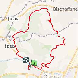
Trail Walking of 10.2 km to be discovered at Grand Est, Bas-Rhin, Obernai. This trail is proposed by Robert62.

Description

Rando au départ du VVF d'Orbernai vers le Mont National (via un sentier escarpé avec de nombreuses marches  sur la gauche avant d'arriver en ville) passage au mont National en profitant d'une belle vue sur la ville avec la chaine des Vosges à l'horizon poursuite vers le couvent de Bischenberg avec son magnifique chemin de croix très original près de la chapelle dédiée à Notre-Dame-des-Sept-Douleurs. Retour par Bischoffshein avec un panorama vers la plaine d'Alsace au loin la forêt Noire et Strasbourg, on devine même le clocher de la cathédrale.

Elevation profile

Positioning

Country:
France
Region :
Grand Est
Department/Province :
Bas-Rhin
Municipality :
Obernai
Location:
Unknown
Start:(UTM)
386807 ; 5369116 (32U) N.

Trails nearby

Trail Walking Ottrott - Le circuit sud du Mur Païen - Photo
Walking
VacheKiri67

Walking

Easy
(2)
Ottrott, Grand Est, Bas-Rhin, France
4.9 km | 6.3 km-effort
1h 56min
No
Trail Walking Ottrott - Le Mont Sainte-Odile depuis Otrott - Photo
Walking
VacheKiri67

Walking

Medium
(1)
Ottrott, Grand Est, Bas-Rhin, France
13 km | 20 km-effort
6h 18min
Yes
Trail Walking Ottrott - Mur Paien complet - Photo
Walking
markrei

Walking

Medium
(1)
Ottrott, Grand Est, Bas-Rhin, France
12 km | 16.4 km-effort
5h 25min
Yes
Trail Walking Obernai - Obernai gare - Mont St Odile - Photo
Walking
tracegps

Walking

Difficult
(2)
Obernai, Grand Est, Bas-Rhin, France
20 km | 29 km-effort
5h 0min
Yes
Trail Mountain bike Ottrott - Sainte-Odile East-Face - Photo
Mountain bike
tracegps

Mountain bike

Difficult
(1)
Ottrott, Grand Est, Bas-Rhin, France
24 km | 39 km-effort
3h 0min
Yes
Trail On foot Rosheim - Circuit du Vignoble - Photo
On foot
PRO

On foot

Easy
Rosheim, Grand Est, Bas-Rhin, France
8.8 km | 11.7 km-effort
2h 38min
Yes
Trail On foot Bischoffsheim - Circuit des Balcons - Photo
On foot
PRO

On foot

Easy
(1)
Bischoffsheim, Grand Est, Bas-Rhin, France
12.4 km | 15.4 km-effort
3h 30min
Yes
Trail Walking Obernai - sentier des merveilles - Photo
Walking
semila

Walking

Difficult
(1)
Obernai, Grand Est, Bas-Rhin, France
11 km | 16.6 km-effort
4h 8min
Yes
Trail Mountain bike Rosheim - schnacker tour le grand 8 circuit magique - Photo
Mountain bike
raphnou

Mountain bike

Difficult
(1)
Rosheim, Grand Est, Bas-Rhin, France
29 km | 39 km-effort
2h 30min
Yes


Close
My subscriptions