Trail Mountain bike Saint-Vallier-de-Thiey - Boucle 30 km au Nord de St Vallier - Photo
 Reich
Reich

User

© OpenStreetMap contributors
Length
Length
30 km
Max alt
Max alt
1167 m
Uphill gradient
Uphill gradient
816 m
Km-Effort
Km-Effort  
41 km
Min alt
Min alt
522 m
Downhill gradient
Downhill gradient
822 m
Boucle
Boucle
Yes
Creation date :
2019-06-23 10:39:28.054
Updated on :
2019-06-23 14:59:29.344

(0 Reviews)

Mountain bike
Mountain bike
3h38
Difficulty : Medium
Electric bike
Electric bike
3h00
Difficulty : Medium

Scan this QR Code to open this trail in the SityTrail application

FREE GPS app for hiking

Logo SityTrail SityTrail

IGN / Geographical institutes

Download SityTrail from the App Store Download SityTrail from Google Play

Logo SityTrail SityTrail World

The world is yours!

Download SityTrail from the App Store Download SityTrail from Google Play Download SityTrail on Huawei AppGallery

About

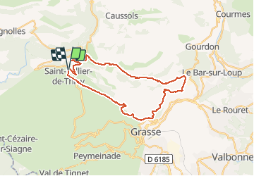
Trail Mountain bike of 30 km to be discovered at Provence-Alpes-Côte d'Azur, Maritime Alps, Saint-Vallier-de-Thiey. This trail is proposed by Reich.

Description

Départ du Grand pré/Col du Ferrier/Plateau de la Malle/Sentier de Gourdon/La Sarrée/Roquevignon/Le Pilon/St Vallier
Un peu de poussage pour rejoindre l'entrée du domaine de la Malle. Sentier un peu technique car pierreux jusqu'à la Sarrée, super vue sur mer. Pas de point d'eau sur le trajet, sauf le snack du karting à la Sarrée. Retour de la prison par la route.

Elevation profile

Positioning

Country:
France
Region :
Provence-Alpes-Côte d'Azur
Department/Province :
Maritime Alps
Municipality :
Saint-Vallier-de-Thiey
Location:
Unknown
Start:(UTM)
326638 ; 4841117 (32T) N.

Trails nearby

Trail Walking Caussols - Le Haut Montet 1335m, Plateau de Caussols - Photo
Walking
tracegps

Walking

Easy
(1)
Caussols, Provence-Alpes-Côte d'Azur, Maritime Alps, France
13.5 km | 18.6 km-effort
4h 0min
Yes
Trail Walking Saint-Vallier-de-Thiey - Arche de Ponadieu Source de la Pare Baou Mourine Vieux Pont  - Photo
Walking
GUIDE
jouans

Walking

Very difficult
Saint-Vallier-de-Thiey, Provence-Alpes-Côte d'Azur, Maritime Alps, France
19.2 km | 32 km-effort
7h 20min
Yes
Trail Walking Saint-Vallier-de-Thiey - St Vallier de Thiey - Aqueduc de Belletrud - Arche de Ponadieu - Photo
Walking
GUIDE
donda

Walking

Very difficult
Saint-Vallier-de-Thiey, Provence-Alpes-Côte d'Azur, Maritime Alps, France
18.5 km | 31 km-effort
6h 56min
Yes
Trail Walking Saint-Vallier-de-Thiey - canau - Photo
Walking
GUIDE
loca.yves

Walking

Very difficult
Saint-Vallier-de-Thiey, Provence-Alpes-Côte d'Azur, Maritime Alps, France
15.3 km | 23 km-effort
6h 33min
Yes
Trail Walking Escragnolles - escragnolles mourine - Photo
Walking
GUIDE
loca.yves

Walking

Difficult
Escragnolles, Provence-Alpes-Côte d'Azur, Maritime Alps, France
10.9 km | 17.7 km-effort
5h 54min
Yes
Trail On foot Caussols - Plateau de Caussols - Photo
On foot
GUIDE+

On foot

Easy
Caussols, Provence-Alpes-Côte d'Azur, Maritime Alps, France
13.9 km | 19.1 km-effort
4h 20min
Yes
Trail On foot Escragnolles - Plateau de Briasq - Photo
On foot
GUIDE+

On foot

Medium
Escragnolles, Provence-Alpes-Côte d'Azur, Maritime Alps, France
14.1 km | 22 km-effort
4h 56min
Yes
Trail Walking Caussols - La Meute Plateau de Caussols 3 - Photo
Walking
DIDIERLESERT

Walking

Medium
(1)
Caussols, Provence-Alpes-Côte d'Azur, Maritime Alps, France
12.4 km | 17.2 km-effort
4h 0min
Yes
Trail Walking Saint-Vallier-de-Thiey - Grasse - Montagne de Thiey - Photo
Walking
GUIDE
Orcal37

Walking

Medium
Saint-Vallier-de-Thiey, Provence-Alpes-Côte d'Azur, Maritime Alps, France
14.9 km | 25 km-effort
4h 54min
Yes


Close
My subscriptions