![](/images/other/stat-length.png)
![Trail Walking Asco - A Muvrella - Photo](https://media.geolcdn.com/t/1900/400/ext.pjpeg?maxdim=2&url=https%3A%2F%2Fstatic1.geolcdn.com%2Fsiteimages%2Fupload%2Ffiles%2F1553511878bg_sport_marche.png)
A Muvrella
jmheydorff
User
![Length](/images/other/stat-length.png)
Length
2 km
![Max alt](https://static1.geolcdn.com/siteimages/upload/files/1508320355ic_sort_altitude_max_24dp.png)
Max alt
2136 m
![Uphill gradient](https://static1.geolcdn.com/siteimages/upload/files/1508320355ic_sort_den_pos_24dp.png)
Uphill gradient
706 m
![Km-Effort](/images/other/stat-length.png)
Km-Effort
9.1 km
![Min alt](https://static1.geolcdn.com/siteimages/upload/files/1508320355ic_sort_altitude_min_24dp.png)
Min alt
1422 m
![Downhill gradient](https://static1.geolcdn.com/siteimages/upload/files/1508320355ic_sort_den_neg_24dp.png)
Downhill gradient
0 m
![Boucle](https://static1.geolcdn.com/siteimages/upload/files/16400158638029165_repeat_loop_refresh_sync_direction_icon.png)
Boucle
No
Creation date :
2014-12-10 00:00:00.0
Updated on :
2014-12-10 00:00:00.0
![Walking](https://static1.geolcdn.com/sitytour/trail-icons/101.png)
2h05
Difficulty : Medium
![Scan this QR Code to open this trail in the SityTrail application](https://capi.geolives.com/qq0zvz2zws4bq2lad0pu/sitytour/trails/211724/qr.png?size=200)
FREE GPS app for hiking
About
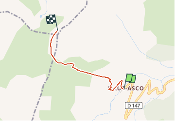
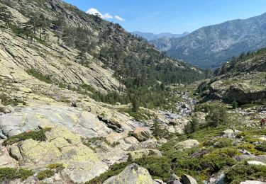
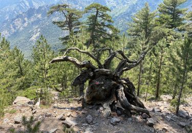
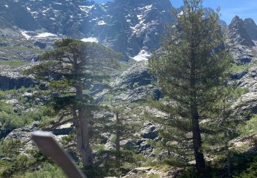
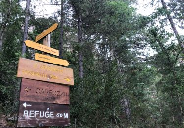
Trail Walking of 2 km to be discovered at Corsica, Haute-Corse, Asco. This trail is proposed by jmheydorff.
Description
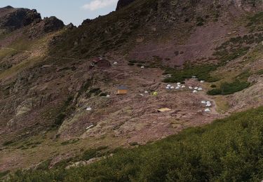
départ chalet du haut-Asco.
prendre le GR20 vers le Nord, jusqu'au Col de Stagnu.
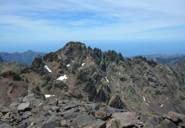
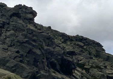
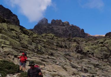
Suivre les cairns qui montent N la ligne de crête jusqu'au sommet d'A Muvrella (2148m): vue 360° sur massifs et mer(golfes de Calvi et de Galeria). en AR: 4 kms 720m 3h00.
Positioning
Country:
France
Region :
Corsica
Department/Province :
Haute-Corse
Municipality :
Asco
Location:
Unknown
Start:(Dec)
Start:(UTM)
493686 ; 4694543 (32T) N.
Comments
Trails nearby
![Trail Walking Asco - Asco la bergerie de vallonne - Photo](https://media.geolcdn.com/t/375/260/4e63b28e-ac12-4bc9-ade1-5430aad7b53b.jpg&format=jpg&maxdim=2)
![Walking Walking](https://static1.geolcdn.com/sitytour/trail-icons/101.png)
Asco la bergerie de vallonne
Walking
Very difficult
Asco,
Corsica,
Haute-Corse,
France
![](/images/other/stat-length.png)
10.4 km | 26 km-effort
9h 15min
![](https://static1.geolcdn.com/siteimages/upload/files/16400158638029165_repeat_loop_refresh_sync_direction_icon.png)
No
![Trail Walking Calenzana - Gr20 Caruzzo Ascorbique - Photo](https://media.geolcdn.com/t/375/260/283be13d-2a81-40ab-b602-c3c97bf8108c.jpg&format=jpg&maxdim=2)
![Walking Walking](https://static1.geolcdn.com/sitytour/trail-icons/101.png)
Gr20 Caruzzo Ascorbique
Walking
Very difficult
Calenzana,
Corsica,
Haute-Corse,
France
![](/images/other/stat-length.png)
4.9 km | 14.7 km-effort
2h 27min
![](https://static1.geolcdn.com/siteimages/upload/files/16400158638029165_repeat_loop_refresh_sync_direction_icon.png)
No
![Trail Walking Asco - Monte Cintu - Photo](https://media.geolcdn.com/t/375/260/d5fea350-e170-4abb-83f3-a276dc99c0a3.jpg&format=jpg&maxdim=2)
![Walking Walking](https://static1.geolcdn.com/sitytour/trail-icons/101.png)
Monte Cintu
Walking
Very difficult
Asco,
Corsica,
Haute-Corse,
France
![](/images/other/stat-length.png)
8.1 km | 22 km-effort
5h 36min
![](https://static1.geolcdn.com/siteimages/upload/files/16400158638029165_repeat_loop_refresh_sync_direction_icon.png)
No
![Trail Walking Asco - La Pointe des Eboulis - Photo](https://media.geolcdn.com/t/375/260/ext.jpg?maxdim=2&url=https%3A%2F%2Fservices.sitytrail.com%2FGeolivesWS%2FDownloadMedia.ashx%3FTrailID%3D129659%26Media%3D13187_6.jpg)
![Walking Walking](https://static1.geolcdn.com/sitytour/trail-icons/101.png)
La Pointe des Eboulis
Walking
Difficult
Asco,
Corsica,
Haute-Corse,
France
![](/images/other/stat-length.png)
4.6 km | 16.5 km-effort
5h 0min
![](https://static1.geolcdn.com/siteimages/upload/files/16400158638029165_repeat_loop_refresh_sync_direction_icon.png)
No
![Trail Walking Asco - Gr 20 ancienne étape -cirque de la solitude - Photo](https://media.geolcdn.com/t/375/260/54bb9873-0ea6-4d84-b03f-42a47d5afe8f.jpg&format=jpg&maxdim=2)
![Walking Walking](https://static1.geolcdn.com/sitytour/trail-icons/101.png)
Gr 20 ancienne étape -cirque de la solitude
Walking
Very difficult
Asco,
Corsica,
Haute-Corse,
France
![](/images/other/stat-length.png)
9.2 km | 22 km-effort
8h 20min
![](https://static1.geolcdn.com/siteimages/upload/files/16400158638029165_repeat_loop_refresh_sync_direction_icon.png)
No
![Trail sport Asco - Au pied du Monté Cinto - Photo](https://media.geolcdn.com/t/375/260/28d6dda0-f89c-4678-8421-9831cbcc647b.jpg&format=jpg&maxdim=2)
Au pied du Monté Cinto
sport
Very easy
Asco,
Corsica,
Haute-Corse,
France
![](/images/other/stat-length.png)
4.1 km | 10.4 km-effort
Unknown
![](https://static1.geolcdn.com/siteimages/upload/files/16400158638029165_repeat_loop_refresh_sync_direction_icon.png)
No
![Trail Walking Albertacce - GR20 Corse 5 étape - Photo](https://media.geolcdn.com/t/375/260/358b3454-cbc2-47d3-abc9-d71ba5043f91.jpg&format=jpg&maxdim=2)
![Walking Walking](https://static1.geolcdn.com/sitytour/trail-icons/101.png)
GR20 Corse 5 étape
Walking
Difficult
Albertacce,
Corsica,
Haute-Corse,
France
![](/images/other/stat-length.png)
5.9 km | 14.8 km-effort
5h 41min
![](https://static1.geolcdn.com/siteimages/upload/files/16400158638029165_repeat_loop_refresh_sync_direction_icon.png)
No
![Trail Walking Asco - GR20 Corse étape 4 - Photo](https://media.geolcdn.com/t/375/260/e2d61f2d-d6c4-4dca-9633-52caa093906f.jpg&format=jpg&maxdim=2)
![Walking Walking](https://static1.geolcdn.com/sitytour/trail-icons/101.png)
GR20 Corse étape 4
Walking
Very difficult
Asco,
Corsica,
Haute-Corse,
France
![](/images/other/stat-length.png)
6.7 km | 22 km-effort
9h 3min
![](https://static1.geolcdn.com/siteimages/upload/files/16400158638029165_repeat_loop_refresh_sync_direction_icon.png)
No
![Walking Walking](https://static1.geolcdn.com/sitytour/trail-icons/101.png)
Carrozzu - Ascu Stagnu - Sa 31/07/21
Walking
Difficult
Calenzana,
Corsica,
Haute-Corse,
France
![](/images/other/stat-length.png)
6.4 km | 16.8 km-effort
8h 14min
![](https://static1.geolcdn.com/siteimages/upload/files/16400158638029165_repeat_loop_refresh_sync_direction_icon.png)
No