![](/images/other/stat-length.png)
![Trail Walking La Salle-les-Alpes - Le Sentier Botanique du Bez - Photo](https://media.geolcdn.com/t/1900/400/ext.pjpeg?maxdim=2&url=https%3A%2F%2Fstatic1.geolcdn.com%2Fsiteimages%2Fupload%2Ffiles%2F1553511878bg_sport_marche.png)
Le Sentier Botanique du Bez
Thomasdanielle
User
![Length](/images/other/stat-length.png)
![Max alt](https://static1.geolcdn.com/siteimages/upload/files/1508320355ic_sort_altitude_max_24dp.png)
![Uphill gradient](https://static1.geolcdn.com/siteimages/upload/files/1508320355ic_sort_den_pos_24dp.png)
![Km-Effort](/images/other/stat-length.png)
![Min alt](https://static1.geolcdn.com/siteimages/upload/files/1508320355ic_sort_altitude_min_24dp.png)
![Downhill gradient](https://static1.geolcdn.com/siteimages/upload/files/1508320355ic_sort_den_neg_24dp.png)
![Boucle](https://static1.geolcdn.com/siteimages/upload/files/16400158638029165_repeat_loop_refresh_sync_direction_icon.png)
![Walking](https://static1.geolcdn.com/sitytour/trail-icons/101.png)
2h04
Difficulty : Medium
![Scan this QR Code to open this trail in the SityTrail application](https://capi.geolives.com/qq0zvz2zws4bq2lad0pu/sitytour/trails/2110909/qr.png?size=200)
FREE GPS app for hiking
About
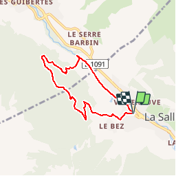
Trail Walking of 6.2 km to be discovered at Provence-Alpes-Côte d'Azur, Hautes-Alpes, La Salle-les-Alpes. This trail is proposed by Thomasdanielle.
Description
Stationner sur le grand parking face à l'Office de Tourisme de Villeneuve.
(D/A) S'engager dans la Route de Roze puis longer les boutiques dans le Chemin de l'Oratoire. Dans le virage à angle droit, quitter ce chemin goudronné pour prendre la sente longeant le canal. Atteindre le cimetière.
(1) Rester sur cette sente, contourner le village du Club Méditerranée, prolonger et retrouver la large piste forestière desservant les alpages.
(2) La prendre à gauche et la suivre jusqu'au carrefour du sentier botanique.
(3) Quitter la piste et entamer à droite la montée de ce sentier. Après une ascension relativement aisée rejoindre un nouveau carrefour.
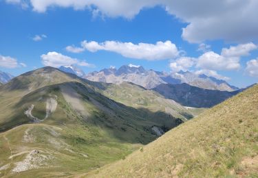
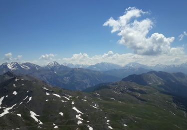
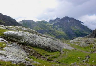
(4) S'engager dans la branche de droite qui mène rapidement au point culminant. Commencer alors la descente dans une direction globale Nord-Ouest pour rejoindre un virage en lacet à proximité d'une source.
(5) Changer ici complètement de direction pour suivre Sud-Est le sentier. Parvenir à un carrefour à angle droit.
(6) Tourner à gauche, rejoindre le poste électrique. Le contourner pour atteindre la piste parallèle à la Guisane.
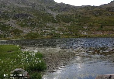
(7) L'emprunter à droite et la suivre, longer le Lac de Pontillas avant de retrouver le parking de départ (D/A).
Points de passage :
D/A : km 0 - alt. 1383m - Parking face à l'OT de Villeneuve
1 : km 0.47 - alt. 1400m - Cimetière
2 : km 1.22 - alt. 1475m - Piste forestière
3 : km 1.58 - alt. 1512m - Début du sentier botanique
4 : km 2.23 - alt. 1658m - Carrefour botanique
5 : km 3.33 - alt. 1521m - Carrefour source
6 : km 3.94 - alt. 1483m - Carrefour avant le poste électrique
7 : km 4.56 - alt. 1400m - Piste en bordure de la Guisane
D/A : km 6.17 - alt. 1383m - Parking face à l'OT de Villeneuve
Informations pratiques
Des bancs sont présents sur tout le parcours.
Nous vous conseillons aussi d'emmener avec vous les cartes IGN papier au 1:25000 de cette randonnée. Cliquez-ici pour les commander : 3536OT, 3536OTR.
Points of interest
Positioning
Comments
Trails nearby
![Trail Walking Saint-Chaffrey - le Prorel au départ de la Serre Chevalier - Photo](https://media.geolcdn.com/t/375/260/8fe43045-679c-4525-8bd4-b81d7f3d7490.jpg&format=jpg&maxdim=2)
![Walking Walking](https://static1.geolcdn.com/sitytour/trail-icons/101.png)
Walking
![](/images/other/stat-length.png)
![](https://static1.geolcdn.com/siteimages/upload/files/16400158638029165_repeat_loop_refresh_sync_direction_icon.png)
![Trail Walking La Salle-les-Alpes - le grand Aréa (boucle) - Photo](https://media.geolcdn.com/t/375/260/2c5e44d9-ecb7-452d-bd8a-94765088c19f.jpg&format=jpg&maxdim=2)
![Walking Walking](https://static1.geolcdn.com/sitytour/trail-icons/101.png)
Walking
![](/images/other/stat-length.png)
![](https://static1.geolcdn.com/siteimages/upload/files/16400158638029165_repeat_loop_refresh_sync_direction_icon.png)
![Trail Walking La Salle-les-Alpes - Grand AREA 21/06/18 - Photo](https://media.geolcdn.com/t/375/260/86fd0548-34c0-4cb0-a2ba-6eed03b231af.jpg&format=jpg&maxdim=2)
![Walking Walking](https://static1.geolcdn.com/sitytour/trail-icons/101.png)
Walking
![](/images/other/stat-length.png)
![](https://static1.geolcdn.com/siteimages/upload/files/16400158638029165_repeat_loop_refresh_sync_direction_icon.png)
![Trail Walking Saint-Chaffrey - Chantemerle-la Salle les Aples 13-08-2018 - Photo](https://media.geolcdn.com/t/375/260/ext.jpg?maxdim=2&url=https%3A%2F%2Fstatic1.geolcdn.com%2Fsiteimages%2Fupload%2Ffiles%2F1553511878bg_sport_marche.png)
![Walking Walking](https://static1.geolcdn.com/sitytour/trail-icons/101.png)
Walking
![](/images/other/stat-length.png)
![](https://static1.geolcdn.com/siteimages/upload/files/16400158638029165_repeat_loop_refresh_sync_direction_icon.png)
![Trail Walking Vallouise-Pelvoux - Lac Eychauda - Photo](https://media.geolcdn.com/t/375/260/ext.jpg?maxdim=2&url=https%3A%2F%2Fservices.sitytrail.com%2FGeolivesWS%2FDownloadMedia.ashx%3FTrailID%3D329974%26Media%3D669f5c07-e99c-447f-ad93-3bbc64c384fe.jpg)
![Walking Walking](https://static1.geolcdn.com/sitytour/trail-icons/101.png)
Walking
![](/images/other/stat-length.png)
![](https://static1.geolcdn.com/siteimages/upload/files/16400158638029165_repeat_loop_refresh_sync_direction_icon.png)
![Trail Mountain bike Saint-Chaffrey - granons tronchet - Photo](https://media.geolcdn.com/t/375/260/ext.jpg?maxdim=2&url=https%3A%2F%2Fstatic1.geolcdn.com%2Fsiteimages%2Fupload%2Ffiles%2F1524743154velo.jpg)
![Mountain bike Mountain bike](https://static1.geolcdn.com/sitytour/trail-icons/202.png)
Mountain bike
![](/images/other/stat-length.png)
![](https://static1.geolcdn.com/siteimages/upload/files/16400158638029165_repeat_loop_refresh_sync_direction_icon.png)
![Trail Walking Saint-Chaffrey - 05 lacs de l'oule,christol,rond 25/08/24 - Photo](https://media.geolcdn.com/t/375/260/8fa64624-96b2-461e-80f5-25df14bfce59.jpg&format=jpg&maxdim=2)
![Walking Walking](https://static1.geolcdn.com/sitytour/trail-icons/101.png)
Walking
![](/images/other/stat-length.png)
![](https://static1.geolcdn.com/siteimages/upload/files/16400158638029165_repeat_loop_refresh_sync_direction_icon.png)
![Trail Walking Le Monêtier-les-Bains - Boucle des Conchiers - Photo](https://media.geolcdn.com/t/375/260/c38d54e3-0bae-4445-9416-7972754b0578.jpg&format=jpg&maxdim=2)
![Walking Walking](https://static1.geolcdn.com/sitytour/trail-icons/101.png)
Walking
![](/images/other/stat-length.png)
![](https://static1.geolcdn.com/siteimages/upload/files/16400158638029165_repeat_loop_refresh_sync_direction_icon.png)
![Trail Walking Le Monêtier-les-Bains - Les Boussardes - Photo](https://media.geolcdn.com/t/375/260/404ff157-d268-4b88-bced-a12b6573121a.jpg&format=jpg&maxdim=2)
![Walking Walking](https://static1.geolcdn.com/sitytour/trail-icons/101.png)
Walking
![](/images/other/stat-length.png)
![](https://static1.geolcdn.com/siteimages/upload/files/16400158638029165_repeat_loop_refresh_sync_direction_icon.png)