![](/images/other/stat-length.png)
![Trail Walking Archail - PIC DE COUARD PIC DU CUCUYON (04) - Photo](https://media.geolcdn.com/t/1900/400/ext.pjpeg?maxdim=2&url=https%3A%2F%2Fstatic1.geolcdn.com%2Fsiteimages%2Fupload%2Ffiles%2F1553511878bg_sport_marche.png)
PIC DE COUARD PIC DU CUCUYON (04)
PATRICK8455
User
![Length](/images/other/stat-length.png)
![Max alt](https://static1.geolcdn.com/siteimages/upload/files/1508320355ic_sort_altitude_max_24dp.png)
![Uphill gradient](https://static1.geolcdn.com/siteimages/upload/files/1508320355ic_sort_den_pos_24dp.png)
![Km-Effort](/images/other/stat-length.png)
![Min alt](https://static1.geolcdn.com/siteimages/upload/files/1508320355ic_sort_altitude_min_24dp.png)
![Downhill gradient](https://static1.geolcdn.com/siteimages/upload/files/1508320355ic_sort_den_neg_24dp.png)
![Boucle](https://static1.geolcdn.com/siteimages/upload/files/16400158638029165_repeat_loop_refresh_sync_direction_icon.png)
![Walking](https://static1.geolcdn.com/sitytour/trail-icons/101.png)
6h02
Difficulty : Very difficult
![Scan this QR Code to open this trail in the SityTrail application](https://capi.geolives.com/qq0zvz2zws4bq2lad0pu/sitytour/trails/2108130/qr.png?size=200)
FREE GPS app for hiking
About
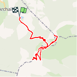
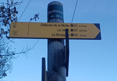
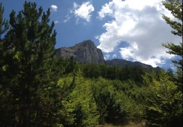
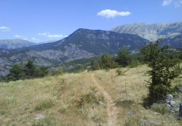
Trail Walking of 12.4 km to be discovered at Provence-Alpes-Côte d'Azur, Alpes-de-Haute-Provence, Archail. This trail is proposed by PATRICK8455.
Description
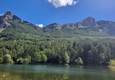
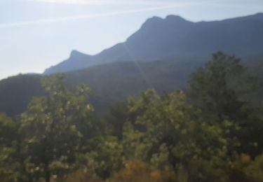
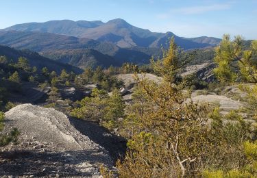
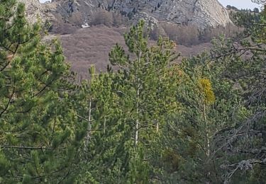
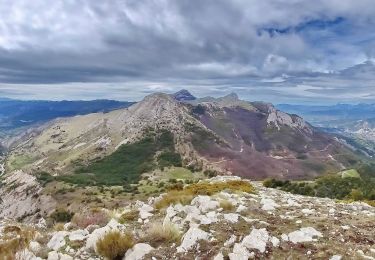
Très belle randonnée au départ en dessus du village d'Archail, qui monte en pente douce et de moins en moins douce vers le le pic de Couard et après le repas au sommet une courte descente pour remonter vers le pic de Cucuyon. Magnifiques paysages observés en haut de ces 2 pics.
Positioning
Comments
Trails nearby
![Trail Walking Archail - Sommet de Couard - Photo](https://media.geolcdn.com/t/375/260/617bf3ec-d772-4852-a48b-6268ec9b769f.jpg&format=jpg&maxdim=2)
![Walking Walking](https://static1.geolcdn.com/sitytour/trail-icons/101.png)
Walking
![](/images/other/stat-length.png)
![](https://static1.geolcdn.com/siteimages/upload/files/16400158638029165_repeat_loop_refresh_sync_direction_icon.png)
![Trail Walking Draix - DRAIX .REFUGE DE BELON .CRETE DE LA BLACHE .O L - Photo](https://media.geolcdn.com/t/375/260/e8831a04-d962-4369-8704-d88e490a9a32.jpg&format=jpg&maxdim=2)
![Walking Walking](https://static1.geolcdn.com/sitytour/trail-icons/101.png)
Walking
![](/images/other/stat-length.png)
![](https://static1.geolcdn.com/siteimages/upload/files/16400158638029165_repeat_loop_refresh_sync_direction_icon.png)
![Trail Walking Marcoux - DIGNE . LES ROBINES DU BANASTRE n ol - Photo](https://media.geolcdn.com/t/375/260/dcce991a-de45-4ec5-a0f2-a1115a3d83c1.jpg&format=jpg&maxdim=2)
![Walking Walking](https://static1.geolcdn.com/sitytour/trail-icons/101.png)
Walking
![](/images/other/stat-length.png)
![](https://static1.geolcdn.com/siteimages/upload/files/16400158638029165_repeat_loop_refresh_sync_direction_icon.png)
![Trail Walking Marcoux - Villar des dourbes archail 734m 12kms - Photo](https://media.geolcdn.com/t/375/260/1fbc3102-e22a-4a79-be22-3dc99b63495b.jpg&format=jpg&maxdim=2)
![Walking Walking](https://static1.geolcdn.com/sitytour/trail-icons/101.png)
Walking
![](/images/other/stat-length.png)
![](https://static1.geolcdn.com/siteimages/upload/files/16400158638029165_repeat_loop_refresh_sync_direction_icon.png)
![Trail Walking Archail - Archail cucuyon 10kms 850m - Photo](https://media.geolcdn.com/t/375/260/c348f6c1-7258-47d7-9586-40bbf4181938.jpg&format=jpg&maxdim=2)
![Walking Walking](https://static1.geolcdn.com/sitytour/trail-icons/101.png)
Walking
![](/images/other/stat-length.png)
![](https://static1.geolcdn.com/siteimages/upload/files/16400158638029165_repeat_loop_refresh_sync_direction_icon.png)
![Trail Walking Draix - 20210506_Draix - Tête de Chabane - Photo](https://media.geolcdn.com/t/375/260/0a858e9b-ff56-4fb8-8c1f-13fe4add2cbd.jpg&format=jpg&maxdim=2)
![Walking Walking](https://static1.geolcdn.com/sitytour/trail-icons/101.png)
Walking
![](/images/other/stat-length.png)
![](https://static1.geolcdn.com/siteimages/upload/files/16400158638029165_repeat_loop_refresh_sync_direction_icon.png)
![Trail Walking Le Brusquet - pierres ocres - Photo](https://media.geolcdn.com/t/375/260/c4f58e11-452c-48be-8c08-199d0d0829dc.jpg&format=jpg&maxdim=2)
![Walking Walking](https://static1.geolcdn.com/sitytour/trail-icons/101.png)
Walking
![](/images/other/stat-length.png)
![](https://static1.geolcdn.com/siteimages/upload/files/16400158638029165_repeat_loop_refresh_sync_direction_icon.png)
![Trail Walking Archail - Randoguide - Photo](https://media.geolcdn.com/t/375/260/ext.jpg?maxdim=2&url=https%3A%2F%2Fservices.sitytrail.com%2FGeolivesWS%2FDownloadMedia.ashx%3FTrailID%3D142239%26Media%3D20120729151454.jpg)
![Walking Walking](https://static1.geolcdn.com/sitytour/trail-icons/101.png)
Walking
![](/images/other/stat-length.png)
![](https://static1.geolcdn.com/siteimages/upload/files/16400158638029165_repeat_loop_refresh_sync_direction_icon.png)
![Trail Mountain bike Archail - Grande Traversée des PréAlpes à VTT : La Bâtie Neuve (Maison forestière ruinée) - Col du Défens - Photo](https://media.geolcdn.com/t/375/260/ext.jpg?maxdim=2&url=https%3A%2F%2Fservices.sitytrail.com%2FGeolivesWS%2FDownloadMedia.ashx%3FTrailID%3D104770%26Media%3D8225_1.jpg)
![Mountain bike Mountain bike](https://static1.geolcdn.com/sitytour/trail-icons/202.png)
Mountain bike
![](/images/other/stat-length.png)
![](https://static1.geolcdn.com/siteimages/upload/files/16400158638029165_repeat_loop_refresh_sync_direction_icon.png)