


Mevagissey

herve.feurprier
User
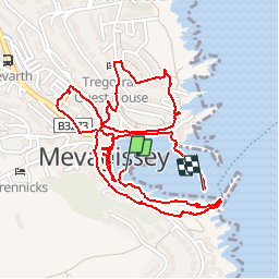

Length
3.1 km

Max alt
49 m

Uphill gradient
73 m
Km-Effort
4.1 km

Min alt
0 m

Downhill gradient
79 m
Boucle
No
Creation date :
2019-06-05 13:53:48.669
Updated on :
2019-06-05 16:13:49.304
1h49
Difficulty : Very easy

FREE GPS app for hiking
 SityTrail
IGN / Geographical institutes
SityTrail World
The world is yours!
About
Trail Walking of 3.1 km to be discovered at England, Cornwall. This trail is proposed by herve.feurprier.
Positioning
Country:
United Kingdom
Region :
England
Department/Province :
Cornwall
Municipality :
Mevagissey
Location:
Unknown
Start:(Dec)
Start:(UTM)
372698 ; 5570103 (30U) N.
Comments
Trails nearby