Trail Walking Jougne - aiguilles de baulmes et Suchet  - Photo

aiguilles de baulmes et Suchet

 BM25
BM25

User

© OpenStreetMap contributors
Length
Length
21 km
Max alt
Max alt
1576 m
Uphill gradient
Uphill gradient
1039 m
Km-Effort
Km-Effort  
35 km
Min alt
Min alt
1027 m
Downhill gradient
Downhill gradient
1038 m
Boucle
Boucle
Yes
Creation date :
2019-06-04 07:15:54.032
Updated on :
2019-06-06 10:36:51.961

(0 Reviews)

Walking
Walking
6h01
Difficulty : Medium

Scan this QR Code to open this trail in the SityTrail application

FREE GPS app for hiking

Logo SityTrail SityTrail

IGN / Geographical institutes

Download SityTrail from the App Store Download SityTrail from Google Play

Logo SityTrail SityTrail World

The world is yours!

Download SityTrail from the App Store Download SityTrail from Google Play Download SityTrail on Huawei AppGallery

About

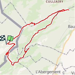
Trail Walking of 21 km to be discovered at Bourgogne-Franche-Comté, Doubs, Jougne. This trail is proposed by BM25.

Description

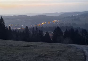
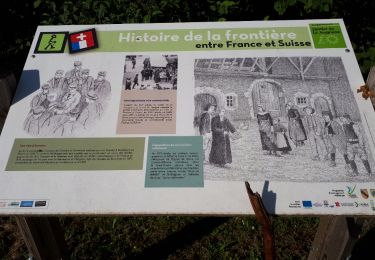
Départ refuge de la queue en dessous d'Entre les Fourgs. Montée vers col de l'aiguillon par sentier mur/frontière, puis ascension sommet des aiguilles de Baulmes, puis crêtes jusqu'au mont de Baulmes, puis descente vers ferme des Naz. Remontée direction ferme de Grange-Neuve; puis ascension du Mont Suchet , les 2 sommets.. Descente vers ferme de la Poillette, puis retour chemin direction Entre les Fourgs et à 1km dans grand virage, prendre à droite et descente en traversée jusqu'à la pierre marquée et descente retour au refuge de la queue.

Elevation profile

Positioning

Country:
France
Region :
Bourgogne-Franche-Comté
Department/Province :
Doubs
Municipality :
Jougne
Location:
Unknown
Start:(UTM)
304542 ; 5183399 (32T) N.

Trails nearby

Trail On foot Les Clées - fixme - fixme - Photo
On foot
GUIDE+

On foot

Easy
Les Clées, Vaud, District du Jura-Nord vaudois, Switzerland
4.1 km | 5.9 km-effort
1h 20min
No
Trail On foot Les Clées - Tourisme pédestre - Photo
On foot
GUIDE+

On foot

Easy
Les Clées, Vaud, District du Jura-Nord vaudois, Switzerland
3.5 km | 4.5 km-effort
1h 0min
No
Trail On foot Sainte-Croix - La Gittaz-Col de l'Aigullon - Photo
On foot
GUIDE+

On foot

Easy
Sainte-Croix, Vaud, District du Jura-Nord vaudois, Switzerland
4.1 km | 6.4 km-effort
1h 26min
No
Trail On foot Sainte-Croix - Sainte Croix-La Gittaz - Photo
On foot
GUIDE+

On foot

Easy
Sainte-Croix, Vaud, District du Jura-Nord vaudois, Switzerland
5.7 km | 8.3 km-effort
1h 53min
No
Trail On foot Sainte-Croix - Chemin de la Gare - Photo
On foot
GUIDE+

On foot

Easy
Sainte-Croix, Vaud, District du Jura-Nord vaudois, Switzerland
6.5 km | 8.6 km-effort
1h 57min
No
Trail Walking Jougne - Aiguilles de Baulmes - Suisse - Photo
Walking
albert39

Walking

Difficult
(1)
Jougne, Bourgogne-Franche-Comté, Doubs, France
16.4 km | 26 km-effort
5h 33min
Yes
Trail On foot Les Fourgs - Le Sentier des Bornes - Photo
On foot
GUIDE+

On foot

Easy
Les Fourgs, Bourgogne-Franche-Comté, Doubs, France
6.4 km | 8 km-effort
1h 48min
No
Trail Walking Jougne - La poyette - Photo
Walking
mallovon

Walking

Medium
Jougne, Bourgogne-Franche-Comté, Doubs, France
11.8 km | 17.9 km-effort
4h 7min
Yes
Trail Walking Jougne - Échappés Cernys - boucle - Photo
Walking
mallovon

Walking

Very easy
Jougne, Bourgogne-Franche-Comté, Doubs, France
6.8 km | 10.8 km-effort
2h 34min
Yes


Close
My subscriptions