![](/images/other/stat-length.png)
![Trail Walking Campile - Boucle de Monte Castellare - Photo](https://media.geolcdn.com/t/1900/400/053b99d8-097d-424d-b87b-e8702b9e5e78.jpg&format=pjpeg&maxdim=2)
Boucle de Monte Castellare
helmut68
User
![Length](/images/other/stat-length.png)
![Max alt](https://static1.geolcdn.com/siteimages/upload/files/1508320355ic_sort_altitude_max_24dp.png)
![Uphill gradient](https://static1.geolcdn.com/siteimages/upload/files/1508320355ic_sort_den_pos_24dp.png)
![Km-Effort](/images/other/stat-length.png)
![Min alt](https://static1.geolcdn.com/siteimages/upload/files/1508320355ic_sort_altitude_min_24dp.png)
![Downhill gradient](https://static1.geolcdn.com/siteimages/upload/files/1508320355ic_sort_den_neg_24dp.png)
![Boucle](https://static1.geolcdn.com/siteimages/upload/files/16400158638029165_repeat_loop_refresh_sync_direction_icon.png)
![Walking](https://static1.geolcdn.com/sitytour/trail-icons/101.png)
3h25
Difficulty : Medium
![Scan this QR Code to open this trail in the SityTrail application](https://capi.geolives.com/qq0zvz2zws4bq2lad0pu/sitytour/trails/2103639/qr.png?size=200)
FREE GPS app for hiking
About
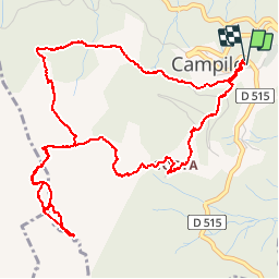
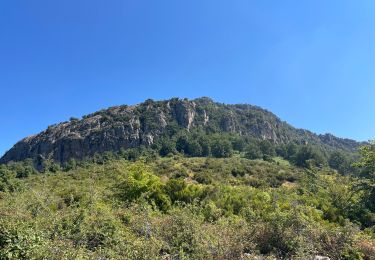
Trail Walking of 7.1 km to be discovered at Corsica, Haute-Corse, Campile. This trail is proposed by helmut68.
Description
D/A Prenez le grand escalier qui s'élève en face de l'église St Pierre puis tourner à droite
Environ trois cents mètres plus haut ,prendre un sentier bien tracé à droite qui s'enfonce dans le sous bois ombragé vers le Nord-ouest puis viré vers Sud -Est. Arrivé à la source et son banc ombragé,le sentier quitte la boucle et part à droite vers l'ouest . Il est balisé par des marques Rouges.
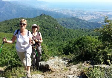
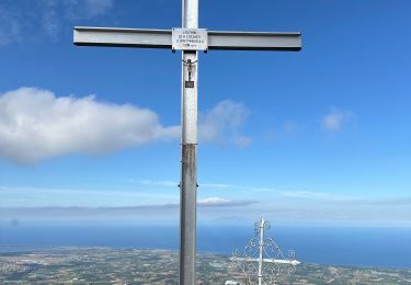
Après avoir serpente entre quelques sommets rocheux ,vous atteignez l'immense chêne vert , isolé à 1000m,cible de cette randonnée " Monte Castellare "
Le retour se fait par le même chemin jusqu'à la bifurcation de la source .
Reprenez la boucle tout droit vers l'est en direction du village de Costa , traversez ce village . A la sortie de Costa , après une croix et juste avant une bergerie ,descendez à droite par un sentier non balisé qui vous permettra de couper toutes les boucles de la route en ligne droite jusqu'à Campile.
Positioning
Comments
Trails nearby
![Trail Walking Silvareccio - Monte Sant'Angelo 06/2015 - Photo](https://media.geolcdn.com/t/375/260/ext.jpg?maxdim=2&url=https%3A%2F%2Fservices.sitytrail.com%2FGeolivesWS%2FDownloadMedia.ashx%3FTrailID%3D323296%26Media%3Dfix__20140630094609.jpg)
![Walking Walking](https://static1.geolcdn.com/sitytour/trail-icons/101.png)
Walking
![](/images/other/stat-length.png)
![](https://static1.geolcdn.com/siteimages/upload/files/16400158638029165_repeat_loop_refresh_sync_direction_icon.png)
![Trail sport Silvareccio - San anghjulu - Photo](https://media.geolcdn.com/t/375/260/130117fa-e0f8-4d57-bfea-4e98590da361.jpg&format=jpg&maxdim=2)
sport
![](/images/other/stat-length.png)
![](https://static1.geolcdn.com/siteimages/upload/files/16400158638029165_repeat_loop_refresh_sync_direction_icon.png)
![Trail Walking Silvareccio - Sant Angelo Vasinca - Photo](https://media.geolcdn.com/t/375/260/ext.jpg?maxdim=2&url=https%3A%2F%2Fservices.sitytrail.com%2FGeolivesWS%2FDownloadMedia.ashx%3FTrailID%3D612758%26Media%3Dfix__20160811154108.jpg)
![Walking Walking](https://static1.geolcdn.com/sitytour/trail-icons/101.png)
Walking
![](/images/other/stat-length.png)
![](https://static1.geolcdn.com/siteimages/upload/files/16400158638029165_repeat_loop_refresh_sync_direction_icon.png)
![Trail Walking Silvareccio - Monte sant’angelo depuis Silvateccio - Photo](https://media.geolcdn.com/t/375/260/e104e725-83e0-436b-8cbd-02b06c44319b.jpg&format=jpg&maxdim=2)
![Walking Walking](https://static1.geolcdn.com/sitytour/trail-icons/101.png)
Walking
![](/images/other/stat-length.png)
![](https://static1.geolcdn.com/siteimages/upload/files/16400158638029165_repeat_loop_refresh_sync_direction_icon.png)
![Trail Walking Silvareccio - San Angelu - Photo](https://media.geolcdn.com/t/375/260/ext.jpg?maxdim=2&url=https%3A%2F%2Fstatic1.geolcdn.com%2Fsiteimages%2Fupload%2Ffiles%2F1553511878bg_sport_marche.png)
![Walking Walking](https://static1.geolcdn.com/sitytour/trail-icons/101.png)
Walking
![](/images/other/stat-length.png)
![](https://static1.geolcdn.com/siteimages/upload/files/16400158638029165_repeat_loop_refresh_sync_direction_icon.png)
![Trail Walking Castello-di-Rostino - castellu di rostinu ponte novu - Photo](https://media.geolcdn.com/t/375/260/ext.jpg?maxdim=2&url=https%3A%2F%2Fstatic1.geolcdn.com%2Fsiteimages%2Fupload%2Ffiles%2F1553511878bg_sport_marche.png)
![Walking Walking](https://static1.geolcdn.com/sitytour/trail-icons/101.png)
Walking
![](/images/other/stat-length.png)
![](https://static1.geolcdn.com/siteimages/upload/files/16400158638029165_repeat_loop_refresh_sync_direction_icon.png)
![Trail Other activity Campile - Campile 22 km - Photo](https://media.geolcdn.com/t/375/260/ext.jpg?maxdim=2&url=https%3A%2F%2Fstatic1.geolcdn.com%2Fsiteimages%2Fupload%2Ffiles%2F1545311037marcheuse_200dpi.jpg)
![Other activity Other activity](https://static1.geolcdn.com/sitytour/trail-icons/900.png)
Other activity
![](/images/other/stat-length.png)
![](https://static1.geolcdn.com/siteimages/upload/files/16400158638029165_repeat_loop_refresh_sync_direction_icon.png)