Trail Walking Lourenzá - 06-03 - Photo
 Rosko65
Rosko65

User

© OpenStreetMap contributors
Length
Length
27 km
Max alt
Max alt
562 m
Uphill gradient
Uphill gradient
955 m
Km-Effort
Km-Effort  
38 km
Min alt
Min alt
48 m
Downhill gradient
Downhill gradient
497 m
Boucle
Boucle
No
Creation date :
2019-06-03 06:12:50.916
Updated on :
2019-06-03 15:06:23.54

(0 Reviews)

Walking
Walking
7h14
Difficulty : Difficult

Scan this QR Code to open this trail in the SityTrail application

FREE GPS app for hiking

Logo SityTrail SityTrail

IGN / Geographical institutes

Download SityTrail from the App Store Download SityTrail from Google Play

Logo SityTrail SityTrail World

The world is yours!

Download SityTrail from the App Store Download SityTrail from Google Play Download SityTrail on Huawei AppGallery

About

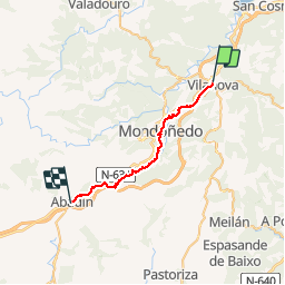
Trail Walking of 27 km to be discovered at Galicia, Lugo, Lourenzá. This trail is proposed by Rosko65.

Description

Camino sur la voie complémentaire entre Lourenza et Abadin

Elevation profile

Positioning

Country:
Spain
Region :
Galicia
Department/Province :
Lugo
Municipality :
Lourenzá
Location:
Unknown
Start:(UTM)
637564 ; 4814813 (29T) N.

Trails nearby

Trail Walking Lourenzá - Vilanova Lourenza - Abadin - Photo
Walking
JackyCouturier

Walking

Medium
(1)
Lourenzá, Galicia, Lugo, Spain
25 km | 35 km-effort
2h 15min
No
Trail Walking Lourenzá - camino del norte   etapa 27   lourenza   gontan - Photo
Walking

Walking

Very easy
Lourenzá, Galicia, Lugo, Spain
24 km | 35 km-effort
Unknown
No


Close
My subscriptions