![](/images/other/stat-length.png)
![Trail Walking Saint-Étienne-de-Baïgorry - Boucle oylarandoy - Photo](https://media.geolcdn.com/t/1900/400/1ab54b66-7f67-4257-86b8-a3289cdc40c1.jpg&format=pjpeg&maxdim=2)
Boucle oylarandoy
jaja64
User
![Length](/images/other/stat-length.png)
Length
14.3 km
![Max alt](https://static1.geolcdn.com/siteimages/upload/files/1508320355ic_sort_altitude_max_24dp.png)
Max alt
926 m
![Uphill gradient](https://static1.geolcdn.com/siteimages/upload/files/1508320355ic_sort_den_pos_24dp.png)
Uphill gradient
796 m
![Km-Effort](/images/other/stat-length.png)
Km-Effort
25 km
![Min alt](https://static1.geolcdn.com/siteimages/upload/files/1508320355ic_sort_altitude_min_24dp.png)
Min alt
151 m
![Downhill gradient](https://static1.geolcdn.com/siteimages/upload/files/1508320355ic_sort_den_neg_24dp.png)
Downhill gradient
796 m
![Boucle](https://static1.geolcdn.com/siteimages/upload/files/16400158638029165_repeat_loop_refresh_sync_direction_icon.png)
Boucle
Yes
Creation date :
2019-06-01 07:02:24.0
Updated on :
2019-06-08 17:33:27.737
![Walking](https://static1.geolcdn.com/sitytour/trail-icons/101.png)
4h55
Difficulty : Medium
![Scan this QR Code to open this trail in the SityTrail application](https://capi.geolives.com/qq0zvz2zws4bq2lad0pu/sitytour/trails/2101000/qr.png?size=200)
FREE GPS app for hiking
About
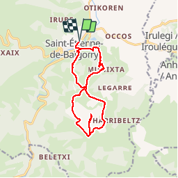
Trail Walking of 14.3 km to be discovered at New Aquitaine, Pyrénées-Atlantiques, Saint-Étienne-de-Baïgorry. This trail is proposed by jaja64.
Description
Boucle. Départ St Étienne de Baïgorry .
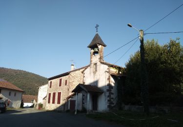
La chapelle d'Oilandoi perchée au sommet du mont est un ancien ermitage voué à la protection des vignes et des cultures.
Positioning
Country:
France
Region :
New Aquitaine
Department/Province :
Pyrénées-Atlantiques
Municipality :
Saint-Étienne-de-Baïgorry
Location:
Unknown
Start:(Dec)
Start:(UTM)
634905 ; 4782075 (30T) N.
Comments
Trails nearby
![Trail Walking Saint-Étienne-de-Baïgorry - iparla - Photo](https://media.geolcdn.com/t/375/260/ext.jpg?maxdim=2&url=https%3A%2F%2Fstatic1.geolcdn.com%2Fsiteimages%2Fupload%2Ffiles%2F1553511878bg_sport_marche.png)
![Walking Walking](https://static1.geolcdn.com/sitytour/trail-icons/101.png)
iparla
Walking
Very easy
(1)
Saint-Étienne-de-Baïgorry,
New Aquitaine,
Pyrénées-Atlantiques,
France
![](/images/other/stat-length.png)
13.5 km | 25 km-effort
4h 45min
![](https://static1.geolcdn.com/siteimages/upload/files/16400158638029165_repeat_loop_refresh_sync_direction_icon.png)
Yes
![Trail Walking Saint-Étienne-de-Baïgorry - GR 10 5ème étape : St Étienne de Baïgorry - St Jean Pied De Port - Photo](https://media.geolcdn.com/t/375/260/f423bfc4-7ba2-4899-9de2-d0d00676b5d2.jpg&format=jpg&maxdim=2)
![Walking Walking](https://static1.geolcdn.com/sitytour/trail-icons/101.png)
GR 10 5ème étape : St Étienne de Baïgorry - St Jean Pied De Port
Walking
Medium
Saint-Étienne-de-Baïgorry,
New Aquitaine,
Pyrénées-Atlantiques,
France
![](/images/other/stat-length.png)
22 km | 36 km-effort
4h 31min
![](https://static1.geolcdn.com/siteimages/upload/files/16400158638029165_repeat_loop_refresh_sync_direction_icon.png)
No
![Trail Walking Saint-Étienne-de-Baïgorry - 20210520 tour depuis Izpegi - Photo](https://media.geolcdn.com/t/375/260/e95b452d-8dd6-4fd8-a386-b8e9176ca32d.jpg&format=jpg&maxdim=2)
![Walking Walking](https://static1.geolcdn.com/sitytour/trail-icons/101.png)
20210520 tour depuis Izpegi
Walking
Easy
Saint-Étienne-de-Baïgorry,
New Aquitaine,
Pyrénées-Atlantiques,
France
![](/images/other/stat-length.png)
8.6 km | 14.7 km-effort
2h 59min
![](https://static1.geolcdn.com/siteimages/upload/files/16400158638029165_repeat_loop_refresh_sync_direction_icon.png)
Yes
![Trail Walking Saint-Étienne-de-Baïgorry - Chapelle ailandoi depuis st Etienne Baïgorry - Photo](https://media.geolcdn.com/t/375/260/bb12cce8-d7ba-4ea6-9157-caee9a53015d.jpg&format=jpg&maxdim=2)
![Walking Walking](https://static1.geolcdn.com/sitytour/trail-icons/101.png)
Chapelle ailandoi depuis st Etienne Baïgorry
Walking
(2)
Saint-Étienne-de-Baïgorry,
New Aquitaine,
Pyrénées-Atlantiques,
France
![](/images/other/stat-length.png)
13.2 km | 24 km-effort
3h 53min
![](https://static1.geolcdn.com/siteimages/upload/files/16400158638029165_repeat_loop_refresh_sync_direction_icon.png)
Yes
![Trail Walking Irouléguy - Jara Irouléguy boucle - Photo](https://media.geolcdn.com/t/375/260/8fa90658-dd00-4408-945a-15c1c317db9d.jpg&format=jpg&maxdim=2)
![Walking Walking](https://static1.geolcdn.com/sitytour/trail-icons/101.png)
Jara Irouléguy boucle
Walking
Medium
Irouléguy,
New Aquitaine,
Pyrénées-Atlantiques,
France
![](/images/other/stat-length.png)
10.4 km | 18.4 km-effort
3h 27min
![](https://static1.geolcdn.com/siteimages/upload/files/16400158638029165_repeat_loop_refresh_sync_direction_icon.png)
Yes
![Trail Walking Saint-Étienne-de-Baïgorry - Urdos pic d'Iparla - Photo](https://media.geolcdn.com/t/375/260/ext.jpg?maxdim=2&url=https%3A%2F%2Fservices.sitytrail.com%2FGeolivesWS%2FDownloadMedia.ashx%3FTrailID%3D1051466%26Media%3Dfix__20180928181715.jpg)
![Walking Walking](https://static1.geolcdn.com/sitytour/trail-icons/101.png)
Urdos pic d'Iparla
Walking
Medium
Saint-Étienne-de-Baïgorry,
New Aquitaine,
Pyrénées-Atlantiques,
France
![](/images/other/stat-length.png)
15.3 km | 28 km-effort
5h 40min
![](https://static1.geolcdn.com/siteimages/upload/files/16400158638029165_repeat_loop_refresh_sync_direction_icon.png)
No
![Trail Walking Saint-Étienne-de-Baïgorry - crêtes d'Iparla depuis Urdos - Photo](https://media.geolcdn.com/t/375/260/ext.jpg?maxdim=2&url=https%3A%2F%2Fservices.sitytrail.com%2FGeolivesWS%2FDownloadMedia.ashx%3FTrailID%3D1003172%26Media%3D20180712130619.jpg)
![Walking Walking](https://static1.geolcdn.com/sitytour/trail-icons/101.png)
crêtes d'Iparla depuis Urdos
Walking
Difficult
(1)
Saint-Étienne-de-Baïgorry,
New Aquitaine,
Pyrénées-Atlantiques,
France
![](/images/other/stat-length.png)
11.7 km | 22 km-effort
5h 17min
![](https://static1.geolcdn.com/siteimages/upload/files/16400158638029165_repeat_loop_refresh_sync_direction_icon.png)
Yes
![Trail Walking Anhaux - Guide Munhoa boucle - Photo](https://media.geolcdn.com/t/375/260/ext.jpg?maxdim=2&url=https%3A%2F%2Fservices.sitytrail.com%2FGeolivesWS%2FDownloadMedia.ashx%3FTrailID%3D966185%26Media%3D20170326155658.jpg)
![Walking Walking](https://static1.geolcdn.com/sitytour/trail-icons/101.png)
Guide Munhoa boucle
Walking
Very easy
Anhaux,
New Aquitaine,
Pyrénées-Atlantiques,
France
![](/images/other/stat-length.png)
13.3 km | 25 km-effort
6h 20min
![](https://static1.geolcdn.com/siteimages/upload/files/16400158638029165_repeat_loop_refresh_sync_direction_icon.png)
Yes
![Trail Other activity Saint-Étienne-de-Baïgorry - TDP N°5 ST ÉTIENNE DE BAIGORRY ST JEAN PIEDS DE PORT - Photo](https://media.geolcdn.com/t/375/260/ext.jpg?maxdim=2&url=https%3A%2F%2Fservices.sitytrail.com%2FGeolivesWS%2FDownloadMedia.ashx%3FTrailID%3D747974%26Media%3Dfix__20170507140146.jpg)
![Other activity Other activity](https://static1.geolcdn.com/sitytour/trail-icons/900.png)
TDP N°5 ST ÉTIENNE DE BAIGORRY ST JEAN PIEDS DE PORT
Other activity
Very easy
Saint-Étienne-de-Baïgorry,
New Aquitaine,
Pyrénées-Atlantiques,
France
![](/images/other/stat-length.png)
19.6 km | 33 km-effort
7h 7min
![](https://static1.geolcdn.com/siteimages/upload/files/16400158638029165_repeat_loop_refresh_sync_direction_icon.png)
No