Trail Walking Tokaj - Tokaj - Photo
 guyS
guyS

User

© OpenStreetMap contributors
Length
Length
6.7 km
Max alt
Max alt
514 m
Uphill gradient
Uphill gradient
423 m
Km-Effort
Km-Effort  
12.3 km
Min alt
Min alt
98 m
Downhill gradient
Downhill gradient
417 m
Boucle
Boucle
No
Creation date :
2019-05-30 10:02:37.73
Updated on :
2019-05-30 13:06:41.099

(0 Reviews)

Walking
Walking
2h38
Difficulty : Difficult

Scan this QR Code to open this trail in the SityTrail application

FREE GPS app for hiking

Logo SityTrail SityTrail

IGN / Geographical institutes

Download SityTrail from the App Store Download SityTrail from Google Play

Logo SityTrail SityTrail World

The world is yours!

Download SityTrail from the App Store Download SityTrail from Google Play Download SityTrail on Huawei AppGallery

About

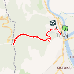
Trail Walking of 6.7 km to be discovered at Great Plain and North, Borsod-Abaúj-Zemplén, Tokaj. This trail is proposed by guyS.

Description

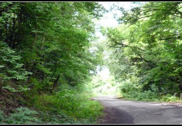
Mont où se trouvent les vignobles "Tokaj". Sur le sommet il y a un point de vue magnifique sur le fleuve Tisza.

Elevation profile

Photos

Positioning

Country:
Hungary
Region :
Great Plain and North
Department/Province :
Borsod-Abaúj-Zemplén
Municipality :
Tokaj
Location:
Unknown
Start:(UTM)
530569 ; 5330126 (34U) N.

Trails nearby

Trail On foot Tokaj - P■ (Tarcal) - Photo
On foot
PRO

On foot

Easy
Tokaj, Great Plain and North, Borsod-Abaúj-Zemplén, Hungary
3.2 km | 3.9 km-effort
53min
No


Close
My subscriptions