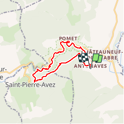
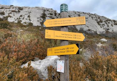
![](/images/other/stat-length.png)
PF-Antonaves - Les Gorges de la Méouge
MicDul
User GUIDE
![Length](/images/other/stat-length.png)
![Max alt](https://static1.geolcdn.com/siteimages/upload/files/1508320355ic_sort_altitude_max_24dp.png)
![Uphill gradient](https://static1.geolcdn.com/siteimages/upload/files/1508320355ic_sort_den_pos_24dp.png)
![Km-Effort](/images/other/stat-length.png)
![Min alt](https://static1.geolcdn.com/siteimages/upload/files/1508320355ic_sort_altitude_min_24dp.png)
![Downhill gradient](https://static1.geolcdn.com/siteimages/upload/files/1508320355ic_sort_den_neg_24dp.png)
![Boucle](https://static1.geolcdn.com/siteimages/upload/files/16400158638029165_repeat_loop_refresh_sync_direction_icon.png)
![Walking](https://static1.geolcdn.com/sitytour/trail-icons/101.png)
5h16
Difficulty : Very difficult
![Scan this QR Code to open this trail in the SityTrail application](https://capi.geolives.com/qq0zvz2zws4bq2lad0pu/sitytour/trails/2096726/qr.png?size=200)
FREE GPS app for hiking
About
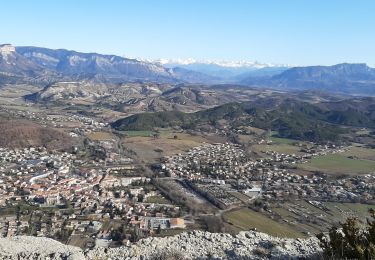
Trail Walking of 13 km to be discovered at Provence-Alpes-Côte d'Azur, Hautes-Alpes, Val-Buëch-Méouge. This trail is proposed by MicDul.
Description
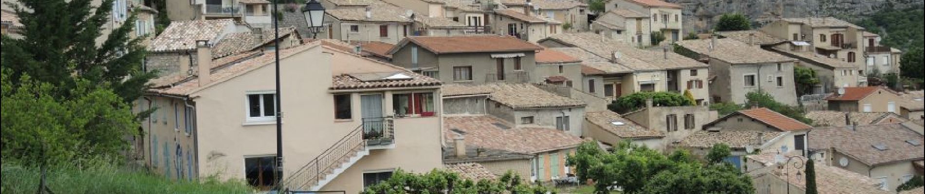
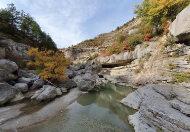
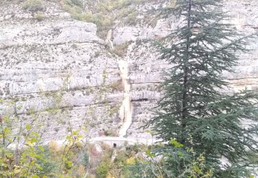
La Méouge est une rivière du sud-est de la France qui prend sa source dans la Drôme sur la commune de Barret-de-Lioure et traverse les Hautes-Alpes. C'est un affluent de rive droite du Buëch, sur le territoire de la commune de Châteauneuf-de-Chabre, donc un sous-affluent du Rhône par la Durance.
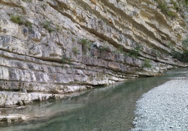
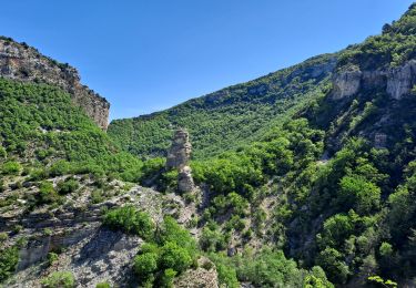
Le matin, agréable montée dans une chêneraie se poursuivant par un étroit sentier en balcon - très fleuri - surplombant la Méouge. Point de vue au rocher du château.
Repas au bord de l'eau.
L'après midi alternance de montées et de descentes le long des gorges (ce qui explique le dénivelé). Pont roman du XIVème et vestiges de moulin. Jolies petites plages.
Quelques passages délicats - bâtons impératifs.
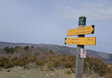
Parking en haut du village après la chapelle.
Positioning
Comments
Trails nearby
![Trail Walking Val-Buëch-Méouge - ANTONAVES, LES GORGES DE LA MEOUGE , ROCHER DU CHATEAU o s - Photo](https://media.geolcdn.com/t/375/260/1487f017-eb98-446f-a2df-e1c366eb0d18.jpg&format=jpg&maxdim=2)
![Walking Walking](https://static1.geolcdn.com/sitytour/trail-icons/101.png)
Walking
![](/images/other/stat-length.png)
![](https://static1.geolcdn.com/siteimages/upload/files/16400158638029165_repeat_loop_refresh_sync_direction_icon.png)
![Trail Walking Barret-sur-Méouge - 05 gorges meouge 03.08.23. semi aquatique un - Photo](https://media.geolcdn.com/t/375/260/f11f4fcf-0a2e-4abf-97b4-d5928fbacb3f.jpg&format=jpg&maxdim=2)
![Walking Walking](https://static1.geolcdn.com/sitytour/trail-icons/101.png)
Walking
![](/images/other/stat-length.png)
![](https://static1.geolcdn.com/siteimages/upload/files/16400158638029165_repeat_loop_refresh_sync_direction_icon.png)
![Trail Walking Val-Buëch-Méouge - Gorges de la Méouge - Photo](https://media.geolcdn.com/t/375/260/b8f27dd7-d0a0-4777-bcd7-e07c51227ff7.jpg&format=jpg&maxdim=2)
![Walking Walking](https://static1.geolcdn.com/sitytour/trail-icons/101.png)
Walking
![](/images/other/stat-length.png)
![](https://static1.geolcdn.com/siteimages/upload/files/16400158638029165_repeat_loop_refresh_sync_direction_icon.png)
![Trail Walking Val-Buëch-Méouge - Pic de Saint-Cyr - Photo](https://media.geolcdn.com/t/375/260/8e5f0bbe-387a-421f-b2fc-4a77ee6dc448.jpg&format=jpg&maxdim=2)
![Walking Walking](https://static1.geolcdn.com/sitytour/trail-icons/101.png)
Walking
![](/images/other/stat-length.png)
![](https://static1.geolcdn.com/siteimages/upload/files/16400158638029165_repeat_loop_refresh_sync_direction_icon.png)
![Trail Walking Val-Buëch-Méouge - les gorges de la Méouge - Photo](https://media.geolcdn.com/t/375/260/59a674dc-fa24-4e7e-a052-fa4b43d50c90.jpg&format=jpg&maxdim=2)
![Walking Walking](https://static1.geolcdn.com/sitytour/trail-icons/101.png)
Walking
![](/images/other/stat-length.png)
![](https://static1.geolcdn.com/siteimages/upload/files/16400158638029165_repeat_loop_refresh_sync_direction_icon.png)
![Trail Walking Val-Buëch-Méouge - SityTrail - PF-Antonaves - Les Gorges de la Méouge - Photo](https://media.geolcdn.com/t/375/260/ext.jpg?maxdim=2&url=https%3A%2F%2Fstatic1.geolcdn.com%2Fsiteimages%2Fupload%2Ffiles%2F1553511878bg_sport_marche.png)
![Walking Walking](https://static1.geolcdn.com/sitytour/trail-icons/101.png)
Walking
![](/images/other/stat-length.png)
![](https://static1.geolcdn.com/siteimages/upload/files/16400158638029165_repeat_loop_refresh_sync_direction_icon.png)
![Trail Walking Val-Buëch-Méouge - CHATEAU NEUF DE CHABRE 05 . Piloubeau , les cretes de Chabre o s - Photo](https://media.geolcdn.com/t/375/260/ed0a937c-11c6-45f3-96a2-ba3aa0d6da41.jpg&format=jpg&maxdim=2)
![Walking Walking](https://static1.geolcdn.com/sitytour/trail-icons/101.png)
Walking
![](/images/other/stat-length.png)
![](https://static1.geolcdn.com/siteimages/upload/files/16400158638029165_repeat_loop_refresh_sync_direction_icon.png)
![Trail Walking Val-Buëch-Méouge - le rocher du château, les gorges de Meouge - Photo](https://media.geolcdn.com/t/375/260/66634572-64d1-4210-8f44-d67187d51fd3.jpg&format=jpg&maxdim=2)
![Walking Walking](https://static1.geolcdn.com/sitytour/trail-icons/101.png)
Walking
![](/images/other/stat-length.png)
![](https://static1.geolcdn.com/siteimages/upload/files/16400158638029165_repeat_loop_refresh_sync_direction_icon.png)
![Trail Walking Val-Buëch-Méouge - Montagne de Chabre (03 2925) - Photo](https://media.geolcdn.com/t/375/260/a269df81-9609-4eca-94a1-3964dba185e3.jpg&format=jpg&maxdim=2)
![Walking Walking](https://static1.geolcdn.com/sitytour/trail-icons/101.png)
Walking
![](/images/other/stat-length.png)
![](https://static1.geolcdn.com/siteimages/upload/files/16400158638029165_repeat_loop_refresh_sync_direction_icon.png)
Magnifique randonnée. Nous avons fait une partie de la rando ds le lit de la rivière, les gorges sont splendides.