![](/images/other/stat-length.png)
![Trail Walking Aydat - 24-MAI-19 11.45.00 - Photo](https://media.geolcdn.com/t/1900/400/cb2dcd0e-fd86-44e2-9c9e-1983a7c0a63b.jpg&format=pjpeg&maxdim=2)
24-MAI-19 11.45.00
rigol05
User
![Length](/images/other/stat-length.png)
Length
6.9 km
![Max alt](https://static1.geolcdn.com/siteimages/upload/files/1508320355ic_sort_altitude_max_24dp.png)
Max alt
881 m
![Uphill gradient](https://static1.geolcdn.com/siteimages/upload/files/1508320355ic_sort_den_pos_24dp.png)
Uphill gradient
92 m
![Km-Effort](/images/other/stat-length.png)
Km-Effort
8.1 km
![Min alt](https://static1.geolcdn.com/siteimages/upload/files/1508320355ic_sort_altitude_min_24dp.png)
Min alt
837 m
![Downhill gradient](https://static1.geolcdn.com/siteimages/upload/files/1508320355ic_sort_den_neg_24dp.png)
Downhill gradient
94 m
![Boucle](https://static1.geolcdn.com/siteimages/upload/files/16400158638029165_repeat_loop_refresh_sync_direction_icon.png)
Boucle
Yes
Creation date :
2019-05-28 09:08:47.325
Updated on :
2019-05-28 09:25:09.231
![Walking](https://static1.geolcdn.com/sitytour/trail-icons/101.png)
--
Difficulty : Easy
![Scan this QR Code to open this trail in the SityTrail application](https://capi.geolives.com/qq0zvz2zws4bq2lad0pu/sitytour/trails/2096363/qr.png?size=200)
FREE GPS app for hiking
About
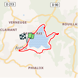
Trail Walking of 6.9 km to be discovered at Auvergne-Rhône-Alpes, Puy-de-Dôme, Aydat. This trail is proposed by rigol05.
Description
Journée des lacs
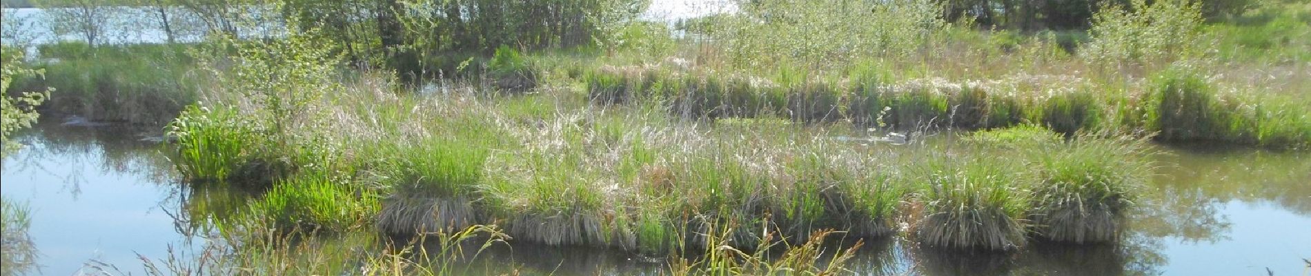
Tour du lac intéressant au départ d'un site bien aménagé pour les loisirs nautiques. La traversée du marais offre un intérêt particulier.
Positioning
Country:
France
Region :
Auvergne-Rhône-Alpes
Department/Province :
Puy-de-Dôme
Municipality :
Aydat
Location:
Unknown
Start:(Dec)
Start:(UTM)
498366 ; 5056590 (31T) N.
Comments
Trails nearby
![Trail Walking Aydat - LacAydatVeyreras_T - Photo](https://media.geolcdn.com/t/375/260/ext.jpg?maxdim=2&url=https%3A%2F%2Fservices.sitytrail.com%2FGeolivesWS%2FDownloadMedia.ashx%3FTrailID%3D844478%26Media%3Dfix__20171012174546.jpg)
![Walking Walking](https://static1.geolcdn.com/sitytour/trail-icons/101.png)
LacAydatVeyreras_T
Walking
Very easy
(1)
Aydat,
Auvergne-Rhône-Alpes,
Puy-de-Dôme,
France
![](/images/other/stat-length.png)
11.1 km | 14.2 km-effort
3h 6min
![](https://static1.geolcdn.com/siteimages/upload/files/16400158638029165_repeat_loop_refresh_sync_direction_icon.png)
Yes
![Trail Walking Aydat - Lassolas-La Vache-Vichatel - Photo](https://media.geolcdn.com/t/375/260/ext.jpg?maxdim=2&url=https%3A%2F%2Fservices.sitytrail.com%2FGeolivesWS%2FDownloadMedia.ashx%3FTrailID%3D602562%26Media%3Dfix__20160723172634.jpg)
![Walking Walking](https://static1.geolcdn.com/sitytour/trail-icons/101.png)
Lassolas-La Vache-Vichatel
Walking
Medium
(1)
Aydat,
Auvergne-Rhône-Alpes,
Puy-de-Dôme,
France
![](/images/other/stat-length.png)
13.2 km | 18.6 km-effort
4h 4min
![](https://static1.geolcdn.com/siteimages/upload/files/16400158638029165_repeat_loop_refresh_sync_direction_icon.png)
Yes
![Trail Walking Aydat - Aydat_Montjuger_ST - Photo](https://media.geolcdn.com/t/375/260/c2caf5c0-1fa1-4013-81dc-2ab6f7f92569.jpg&format=jpg&maxdim=2)
![Walking Walking](https://static1.geolcdn.com/sitytour/trail-icons/101.png)
Aydat_Montjuger_ST
Walking
Easy
(1)
Aydat,
Auvergne-Rhône-Alpes,
Puy-de-Dôme,
France
![](/images/other/stat-length.png)
10.5 km | 12.7 km-effort
3h 0min
![](https://static1.geolcdn.com/siteimages/upload/files/16400158638029165_repeat_loop_refresh_sync_direction_icon.png)
Yes
![Trail Walking Aydat - Aydat_Puy_Rodde - Photo](https://media.geolcdn.com/t/375/260/8eea2914-ded8-4558-a06b-e7583efcbd98.jpg&format=jpg&maxdim=2)
![Walking Walking](https://static1.geolcdn.com/sitytour/trail-icons/101.png)
Aydat_Puy_Rodde
Walking
Medium
(1)
Aydat,
Auvergne-Rhône-Alpes,
Puy-de-Dôme,
France
![](/images/other/stat-length.png)
10.5 km | 13.6 km-effort
3h 15min
![](https://static1.geolcdn.com/siteimages/upload/files/16400158638029165_repeat_loop_refresh_sync_direction_icon.png)
Yes
![Walking Walking](https://static1.geolcdn.com/sitytour/trail-icons/101.png)
puy de Vichatel
Walking
Very easy
(1)
Aydat,
Auvergne-Rhône-Alpes,
Puy-de-Dôme,
France
![](/images/other/stat-length.png)
3.8 km | 5.8 km-effort
1h 13min
![](https://static1.geolcdn.com/siteimages/upload/files/16400158638029165_repeat_loop_refresh_sync_direction_icon.png)
Yes
![Trail On foot Aydat - Les Cheires Hautes - Photo](https://media.geolcdn.com/t/375/260/8868eef4-2c9a-4cff-b569-164b10942dc4.jpeg&format=jpg&maxdim=2)
![On foot On foot](https://static1.geolcdn.com/sitytour/trail-icons/100.png)
Les Cheires Hautes
On foot
Easy
Aydat,
Auvergne-Rhône-Alpes,
Puy-de-Dôme,
France
![](/images/other/stat-length.png)
15.9 km | 20 km-effort
4h 32min
![](https://static1.geolcdn.com/siteimages/upload/files/16400158638029165_repeat_loop_refresh_sync_direction_icon.png)
Yes
![Trail On foot Aydat - Le Lac de la Cassière - Photo](https://media.geolcdn.com/t/375/260/d570a0c9-091c-4e7e-92f0-ef1a2bdb50c5.jpeg&format=jpg&maxdim=2)
![On foot On foot](https://static1.geolcdn.com/sitytour/trail-icons/100.png)
Le Lac de la Cassière
On foot
Easy
Aydat,
Auvergne-Rhône-Alpes,
Puy-de-Dôme,
France
![](/images/other/stat-length.png)
3.2 km | 4 km-effort
54min
![](https://static1.geolcdn.com/siteimages/upload/files/16400158638029165_repeat_loop_refresh_sync_direction_icon.png)
Yes
![Trail On foot Saint-Genès-Champanelle - Nadaillat - Photo](https://media.geolcdn.com/t/375/260/f63239da-1e27-43d7-84c3-ba50289c6d9e.jpeg&format=jpg&maxdim=2)
![On foot On foot](https://static1.geolcdn.com/sitytour/trail-icons/100.png)
Nadaillat
On foot
Easy
Saint-Genès-Champanelle,
Auvergne-Rhône-Alpes,
Puy-de-Dôme,
France
![](/images/other/stat-length.png)
6.6 km | 9.3 km-effort
2h 7min
![](https://static1.geolcdn.com/siteimages/upload/files/16400158638029165_repeat_loop_refresh_sync_direction_icon.png)
Yes
![Trail On foot Aydat - Le Puy de Vichatel - Photo](https://media.geolcdn.com/t/375/260/393a6927-23db-4d99-8cc9-f6649fdba949.jpeg&format=jpg&maxdim=2)
![On foot On foot](https://static1.geolcdn.com/sitytour/trail-icons/100.png)
Le Puy de Vichatel
On foot
Easy
Aydat,
Auvergne-Rhône-Alpes,
Puy-de-Dôme,
France
![](/images/other/stat-length.png)
8.1 km | 10.5 km-effort
2h 22min
![](https://static1.geolcdn.com/siteimages/upload/files/16400158638029165_repeat_loop_refresh_sync_direction_icon.png)
Yes