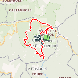

15.3 km | 23 km-effort


User


FREE GPS app for hiking
 SityTrail
IGN / Geographical institutes
SityTrail World
The world is yours!
Trail Walking of 16.8 km to be discovered at Occitania, Lozère, Ventalon en Cévennes. This trail is proposed by ajasse.
Départ à Lezinier sous le temple de St Andeol de Clerguemort (difficile à trouver).
Découverte du patrimoine cévenol.
Architecture rurale, Châtaigneraies.

Walking

Walking

Walking

Walking


Walking

Walking

Walking