![](/images/other/stat-length.png)
![Trail Walking Thann - 9992775-thann - Photo](https://media.geolcdn.com/t/1900/400/ext.pjpeg?maxdim=2&url=https%3A%2F%2Fstatic1.geolcdn.com%2Fsiteimages%2Fupload%2Ffiles%2F1553511878bg_sport_marche.png)
9992775-thann
E.BURCK
User
![Length](/images/other/stat-length.png)
![Max alt](https://static1.geolcdn.com/siteimages/upload/files/1508320355ic_sort_altitude_max_24dp.png)
![Uphill gradient](https://static1.geolcdn.com/siteimages/upload/files/1508320355ic_sort_den_pos_24dp.png)
![Km-Effort](/images/other/stat-length.png)
![Min alt](https://static1.geolcdn.com/siteimages/upload/files/1508320355ic_sort_altitude_min_24dp.png)
![Downhill gradient](https://static1.geolcdn.com/siteimages/upload/files/1508320355ic_sort_den_neg_24dp.png)
![Boucle](https://static1.geolcdn.com/siteimages/upload/files/16400158638029165_repeat_loop_refresh_sync_direction_icon.png)
![Walking](https://static1.geolcdn.com/sitytour/trail-icons/101.png)
3h12
Difficulty : Difficult
![Scan this QR Code to open this trail in the SityTrail application](https://capi.geolives.com/qq0zvz2zws4bq2lad0pu/sitytour/trails/2095718/qr.png?size=200)
FREE GPS app for hiking
About
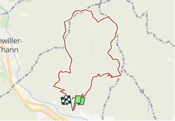
Trail Walking of 10 km to be discovered at Grand Est, Haut-Rhin, Thann. This trail is proposed by E.BURCK.
Description
Thann - Camp des Pyramides - le chêne Wotan - Waldkapelle
9,2 km - Dénivelé 440 m - pas trop difficile (3/6)
Voici un petit circuit classique et toujours agréable, dans un sens comme dans l’autre : au départ de Thann, nous monterons par le GR5 jusqu’au Camp des Pyramides, et le retour se fera par le chêne Wotan et la Waldkapelle.
Départ et arrivée : stationnement le long de la rue du Kattenbachy à THANN.
À partir de la place du Bungert, passer près de la tour des Sorcières et sur le pont de la Thur, et continuer tout droit rue du Rangen
(portion un peu étroite et montante est commune avec l’itinéraire cycliste)
Prendre ensuite à droite la rue du Kattenbachy, direction Engelbourg, et continuer plus haut que l’établissement St-Joseph ; se garer après-avoir fait demi-tour, et alors du côté droit (pas de parking).
Temps de marche : 2 h 40 mn (*). Distance exacte : 9,2 km. Dénivelé positif : 440 m.
Difficulté particulière : certaines portions de la montée.
Conseils : les chaussures de randonnée légères conviendront parfaitement (et les bâtons pour les seniors) ; emporter de quoi boire.
Positioning
Comments
Trails nearby
![Trail Other activity Steinbach - lac du ballon - Photo](https://media.geolcdn.com/t/375/260/ext.jpg?maxdim=2&url=https%3A%2F%2Fservices.sitytrail.com%2FGeolivesWS%2FDownloadMedia.ashx%3FTrailID%3D210434%26Media%3Dfix__20130805111422.jpg)
![Other activity Other activity](https://static1.geolcdn.com/sitytour/trail-icons/900.png)
Other activity
![](/images/other/stat-length.png)
![](https://static1.geolcdn.com/siteimages/upload/files/16400158638029165_repeat_loop_refresh_sync_direction_icon.png)
![Trail Walking Steinbach - Cascade de Erzenbach - Photo](https://media.geolcdn.com/t/375/260/069cb34c-c699-4fdf-8c9c-4524251a300c.jpg&format=jpg&maxdim=2)
![Walking Walking](https://static1.geolcdn.com/sitytour/trail-icons/101.png)
Walking
![](/images/other/stat-length.png)
![](https://static1.geolcdn.com/siteimages/upload/files/16400158638029165_repeat_loop_refresh_sync_direction_icon.png)
![Trail Walking Bourbach-le-Haut - 2024-01-12_14h17m14_239006910 - Photo](https://media.geolcdn.com/t/375/260/d4089ace-97e6-4d95-86a3-a999ece263d3.jpg&format=jpg&maxdim=2)
![Walking Walking](https://static1.geolcdn.com/sitytour/trail-icons/101.png)
Walking
![](/images/other/stat-length.png)
![](https://static1.geolcdn.com/siteimages/upload/files/16400158638029165_repeat_loop_refresh_sync_direction_icon.png)
![Trail Trail Wattwiller - The History Ultra - stage 1 - Photo](https://media.geolcdn.com/t/375/260/ext.jpg?maxdim=2&url=https%3A%2F%2Fstatic1.geolcdn.com%2Fsiteimages%2Fupload%2Ffiles%2F1524743154running.jpg)
![Trail Trail](https://static1.geolcdn.com/sitytour/trail-icons/104.png)
Trail
![](/images/other/stat-length.png)
![](https://static1.geolcdn.com/siteimages/upload/files/16400158638029165_repeat_loop_refresh_sync_direction_icon.png)
![Trail Walking Thann - SityTrail - 2489713 - thann-roche--albert--grumbachkopf - Photo](https://media.geolcdn.com/t/375/260/ext.jpg?maxdim=2&url=https%3A%2F%2Fstatic1.geolcdn.com%2Fsiteimages%2Fupload%2Ffiles%2F1553511878bg_sport_marche.png)
![Walking Walking](https://static1.geolcdn.com/sitytour/trail-icons/101.png)
Walking
![](/images/other/stat-length.png)
![](https://static1.geolcdn.com/siteimages/upload/files/16400158638029165_repeat_loop_refresh_sync_direction_icon.png)
![Trail On foot Bitschwiller-lès-Thann - Bitschwiller les Thann - Rehbrunnel - Abri du Becherkopf - Roche Albert - Photo](https://media.geolcdn.com/t/375/260/ext.jpg?maxdim=2&url=https%3A%2F%2Fstatic1.geolcdn.com%2Fsiteimages%2Fupload%2Ffiles%2F1545311037marcheuse_200dpi.jpg)
![On foot On foot](https://static1.geolcdn.com/sitytour/trail-icons/100.png)
On foot
![](/images/other/stat-length.png)
![](https://static1.geolcdn.com/siteimages/upload/files/16400158638029165_repeat_loop_refresh_sync_direction_icon.png)
![Trail Walking Bitschwiller-lès-Thann - 68 Col du Hundsrück - FA Gsang - retour ThannerHubel - Photo](https://media.geolcdn.com/t/375/260/ext.jpg?maxdim=2&url=https%3A%2F%2Fstatic1.geolcdn.com%2Fsiteimages%2Fupload%2Ffiles%2F1553511878bg_sport_marche.png)
![Walking Walking](https://static1.geolcdn.com/sitytour/trail-icons/101.png)
Walking
![](/images/other/stat-length.png)
![](https://static1.geolcdn.com/siteimages/upload/files/16400158638029165_repeat_loop_refresh_sync_direction_icon.png)
![Trail Walking Thann - Entre Thann et le Molkenrain - Photo](https://media.geolcdn.com/t/375/260/288febbb-1400-419f-925a-b31a67c6a7df.jpg&format=jpg&maxdim=2)
![Walking Walking](https://static1.geolcdn.com/sitytour/trail-icons/101.png)
Walking
![](/images/other/stat-length.png)
![](https://static1.geolcdn.com/siteimages/upload/files/16400158638029165_repeat_loop_refresh_sync_direction_icon.png)
![Trail Electric bike Thann - Thann lac de Kruth - Photo](https://media.geolcdn.com/t/375/260/f55f8e20-2cc2-42d2-8acb-2cc22e065b5e.jpg&format=jpg&maxdim=2)
![Electric bike Electric bike](https://static1.geolcdn.com/sitytour/trail-icons/205.png)
Electric bike
![](/images/other/stat-length.png)
![](https://static1.geolcdn.com/siteimages/upload/files/16400158638029165_repeat_loop_refresh_sync_direction_icon.png)