![](/images/other/stat-length.png)
![Trail Walking Saint-Appolinard - ST APPOLINARD CROIX DES FOURNETS - Photo](https://media.geolcdn.com/t/1900/400/ext.pjpeg?maxdim=2&url=https%3A%2F%2Fstatic1.geolcdn.com%2Fsiteimages%2Fupload%2Ffiles%2F1553511878bg_sport_marche.png)
ST APPOLINARD CROIX DES FOURNETS
novop
User
![Length](/images/other/stat-length.png)
Length
9.5 km
![Max alt](https://static1.geolcdn.com/siteimages/upload/files/1508320355ic_sort_altitude_max_24dp.png)
Max alt
641 m
![Uphill gradient](https://static1.geolcdn.com/siteimages/upload/files/1508320355ic_sort_den_pos_24dp.png)
Uphill gradient
322 m
![Km-Effort](/images/other/stat-length.png)
Km-Effort
13.8 km
![Min alt](https://static1.geolcdn.com/siteimages/upload/files/1508320355ic_sort_altitude_min_24dp.png)
Min alt
412 m
![Downhill gradient](https://static1.geolcdn.com/siteimages/upload/files/1508320355ic_sort_den_neg_24dp.png)
Downhill gradient
322 m
![Boucle](https://static1.geolcdn.com/siteimages/upload/files/16400158638029165_repeat_loop_refresh_sync_direction_icon.png)
Boucle
Yes
Creation date :
2019-05-25 07:14:04.277
Updated on :
2019-05-25 09:02:58.778
![Walking](https://static1.geolcdn.com/sitytour/trail-icons/101.png)
1h34
Difficulty : Easy
![Scan this QR Code to open this trail in the SityTrail application](https://capi.geolives.com/qq0zvz2zws4bq2lad0pu/sitytour/trails/2093497/qr.png?size=200)
FREE GPS app for hiking
About
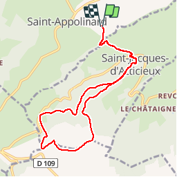
Trail Walking of 9.5 km to be discovered at Auvergne-Rhône-Alpes, Loire, Saint-Appolinard. This trail is proposed by novop.
Description
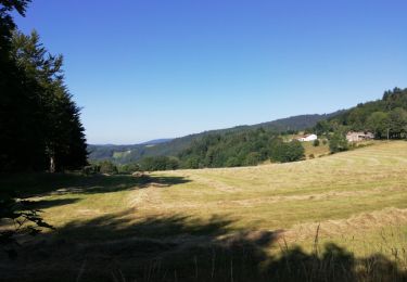
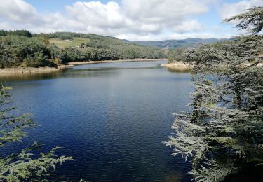
ST APPOLINARD montée sur ST JACQUES puis sentier en forêt variée. Beau point de vue sur le plateau vers la croix des fournets. Les 3 dents etc... pas de difficultés.
Positioning
Country:
France
Region :
Auvergne-Rhône-Alpes
Department/Province :
Loire
Municipality :
Saint-Appolinard
Location:
Unknown
Start:(Dec)
Start:(UTM)
629925 ; 5022105 (31T) N.
Comments
Trails nearby
![Trail On foot Maclas - Maclas - 11,1 km - 227 m de dénivelé - 3h30 - Photo](https://media.geolcdn.com/t/375/260/ext.jpg?maxdim=2&url=https%3A%2F%2Fstatic1.geolcdn.com%2Fsiteimages%2Fupload%2Ffiles%2F1545311037marcheuse_200dpi.jpg)
![On foot On foot](https://static1.geolcdn.com/sitytour/trail-icons/100.png)
Maclas - 11,1 km - 227 m de dénivelé - 3h30
On foot
Medium
(1)
Maclas,
Auvergne-Rhône-Alpes,
Loire,
France
![](/images/other/stat-length.png)
11.1 km | 14.1 km-effort
3h 30min
![](https://static1.geolcdn.com/siteimages/upload/files/16400158638029165_repeat_loop_refresh_sync_direction_icon.png)
Yes
![Trail sport Brossainc - Brossainc lac du Ternay - Photo](https://media.geolcdn.com/t/375/260/b64da57c-4088-40be-b1ff-c36963d68b0b.jpg&format=jpg&maxdim=2)
Brossainc lac du Ternay
sport
Very easy
Brossainc,
Auvergne-Rhône-Alpes,
Ardèche,
France
![](/images/other/stat-length.png)
18 km | 25 km-effort
Unknown
![](https://static1.geolcdn.com/siteimages/upload/files/16400158638029165_repeat_loop_refresh_sync_direction_icon.png)
Yes
![Trail Walking Colombier - 42-st-sabin-pilat-18km-610m-juil21 - Photo](https://media.geolcdn.com/t/375/260/6645f7a0-e301-4c2c-adfe-0d10cb403641.jpg&format=jpg&maxdim=2)
![Walking Walking](https://static1.geolcdn.com/sitytour/trail-icons/101.png)
42-st-sabin-pilat-18km-610m-juil21
Walking
Medium
Colombier,
Auvergne-Rhône-Alpes,
Loire,
France
![](/images/other/stat-length.png)
18.9 km | 27 km-effort
5h 19min
![](https://static1.geolcdn.com/siteimages/upload/files/16400158638029165_repeat_loop_refresh_sync_direction_icon.png)
Yes
![Trail Walking Colombier - 42-st-sabin-cret-de-perdrix-16km-620m - Photo](https://media.geolcdn.com/t/375/260/a762516b-441d-4621-b446-f73b335578ba.jpg&format=jpg&maxdim=2)
![Walking Walking](https://static1.geolcdn.com/sitytour/trail-icons/101.png)
42-st-sabin-cret-de-perdrix-16km-620m
Walking
Medium
Colombier,
Auvergne-Rhône-Alpes,
Loire,
France
![](/images/other/stat-length.png)
16 km | 24 km-effort
3h 57min
![](https://static1.geolcdn.com/siteimages/upload/files/16400158638029165_repeat_loop_refresh_sync_direction_icon.png)
Yes
![Trail Walking Savas - 07 Lac du ternay / croix des Blaches 8km 230M - Photo](https://media.geolcdn.com/t/375/260/bb40ad17-bd04-46d1-9ad9-555e9dab889c.jpg&format=jpg&maxdim=2)
![Walking Walking](https://static1.geolcdn.com/sitytour/trail-icons/101.png)
07 Lac du ternay / croix des Blaches 8km 230M
Walking
Very easy
(1)
Savas,
Auvergne-Rhône-Alpes,
Ardèche,
France
![](/images/other/stat-length.png)
8 km | 11 km-effort
2h 20min
![](https://static1.geolcdn.com/siteimages/upload/files/16400158638029165_repeat_loop_refresh_sync_direction_icon.png)
Yes
![Trail Walking Véranne - pilat-TDF-saint sabin - Photo](https://media.geolcdn.com/t/375/260/ext.jpg?maxdim=2&url=https%3A%2F%2Fstatic1.geolcdn.com%2Fsiteimages%2Fupload%2Ffiles%2F1553511878bg_sport_marche.png)
![Walking Walking](https://static1.geolcdn.com/sitytour/trail-icons/101.png)
pilat-TDF-saint sabin
Walking
Medium
(1)
Véranne,
Auvergne-Rhône-Alpes,
Loire,
France
![](/images/other/stat-length.png)
17.9 km | 26 km-effort
5h 20min
![](https://static1.geolcdn.com/siteimages/upload/files/16400158638029165_repeat_loop_refresh_sync_direction_icon.png)
Yes
![Trail Walking Véranne - Col de l oeuillon - St sabin - Col de l oeuillon - Photo](https://media.geolcdn.com/t/375/260/ext.jpg?maxdim=2&url=https%3A%2F%2Fservices.sitytrail.com%2FGeolivesWS%2FDownloadMedia.ashx%3FTrailID%3D493080%26Media%3Dfix__20151112145334.jpg)
![Walking Walking](https://static1.geolcdn.com/sitytour/trail-icons/101.png)
Col de l oeuillon - St sabin - Col de l oeuillon
Walking
Easy
Véranne,
Auvergne-Rhône-Alpes,
Loire,
France
![](/images/other/stat-length.png)
6.3 km | 9.3 km-effort
1h 42min
![](https://static1.geolcdn.com/siteimages/upload/files/16400158638029165_repeat_loop_refresh_sync_direction_icon.png)
Yes
![Trail Mountain bike Bessey - Autour de Pélussin - Photo](https://media.geolcdn.com/t/375/260/ext.jpg?maxdim=2&url=https%3A%2F%2Fservices.sitytrail.com%2FGeolivesWS%2FDownloadMedia.ashx%3FTrailID%3D101885%26Media%3D2170_3.jpg)
![Mountain bike Mountain bike](https://static1.geolcdn.com/sitytour/trail-icons/202.png)
Autour de Pélussin
Mountain bike
Difficult
Bessey,
Auvergne-Rhône-Alpes,
Loire,
France
![](/images/other/stat-length.png)
29 km | 38 km-effort
3h 0min
![](https://static1.geolcdn.com/siteimages/upload/files/16400158638029165_repeat_loop_refresh_sync_direction_icon.png)
Yes
![Trail Walking Saint-Julien-Molin-Molette - 09 mai 2024 Saint julien Molin molette - Photo](https://media.geolcdn.com/t/375/260/aac5c3c7-b172-4a0d-a1d7-984a8842df38.jpg&format=jpg&maxdim=2)
![Walking Walking](https://static1.geolcdn.com/sitytour/trail-icons/101.png)
09 mai 2024 Saint julien Molin molette
Walking
Very difficult
Saint-Julien-Molin-Molette,
Auvergne-Rhône-Alpes,
Loire,
France
![](/images/other/stat-length.png)
22 km | 34 km-effort
7h 1min
![](https://static1.geolcdn.com/siteimages/upload/files/16400158638029165_repeat_loop_refresh_sync_direction_icon.png)
Yes