![](/images/other/stat-length.png)
![Trail Walking Beaufort - La Pierra Menta et le Lac d'Amour - Photo](https://media.geolcdn.com/t/1900/400/ext.pjpeg?maxdim=2&url=https%3A%2F%2Fstatic1.geolcdn.com%2Fsiteimages%2Fupload%2Ffiles%2F1553511878bg_sport_marche.png)
La Pierra Menta et le Lac d'Amour
namoureux
User
![Length](/images/other/stat-length.png)
Length
10.3 km
![Max alt](https://static1.geolcdn.com/siteimages/upload/files/1508320355ic_sort_altitude_max_24dp.png)
Max alt
2559 m
![Uphill gradient](https://static1.geolcdn.com/siteimages/upload/files/1508320355ic_sort_den_pos_24dp.png)
Uphill gradient
883 m
![Km-Effort](/images/other/stat-length.png)
Km-Effort
22 km
![Min alt](https://static1.geolcdn.com/siteimages/upload/files/1508320355ic_sort_altitude_min_24dp.png)
Min alt
1700 m
![Downhill gradient](https://static1.geolcdn.com/siteimages/upload/files/1508320355ic_sort_den_neg_24dp.png)
Downhill gradient
881 m
![Boucle](https://static1.geolcdn.com/siteimages/upload/files/16400158638029165_repeat_loop_refresh_sync_direction_icon.png)
Boucle
Yes
Creation date :
2019-05-24 10:14:15.469
Updated on :
2019-05-24 10:16:56.964
![Walking](https://static1.geolcdn.com/sitytour/trail-icons/101.png)
4h21
Difficulty : Very difficult
![Scan this QR Code to open this trail in the SityTrail application](https://capi.geolives.com/qq0zvz2zws4bq2lad0pu/sitytour/trails/2092754/qr.png?size=200)
FREE GPS app for hiking
About
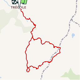
Trail Walking of 10.3 km to be discovered at Auvergne-Rhône-Alpes, Savoy, Beaufort. This trail is proposed by namoureux.
Description
Pt de départ : N 45.659658° / E 6.635803°
Randonnée dans un décor splendide : le barrage de Roselend, la Pierra Menta, le Beaufortain, un bout de Mont Blanc.
Positioning
Country:
France
Region :
Auvergne-Rhône-Alpes
Department/Province :
Savoy
Municipality :
Beaufort
Location:
Unknown
Start:(Dec)
Start:(UTM)
315754 ; 5059007 (32T) N.
Comments
Trails nearby
![Trail Walking Beaufort - Du refuge du Plan de la laie au refuge de la Croix du Bonhomme - Photo](https://media.geolcdn.com/t/375/260/ext.jpg?maxdim=2&url=https%3A%2F%2Fservices.sitytrail.com%2FGeolivesWS%2FDownloadMedia.ashx%3FTrailID%3D605207%26Media%3D510e5eef-7385-455b-8e69-ea984ac16f39.jpg)
![Walking Walking](https://static1.geolcdn.com/sitytour/trail-icons/101.png)
Du refuge du Plan de la laie au refuge de la Croix du Bonhomme
Walking
Medium
(1)
Beaufort,
Auvergne-Rhône-Alpes,
Savoy,
France
![](/images/other/stat-length.png)
8 km | 16 km-effort
4h 27min
![](https://static1.geolcdn.com/siteimages/upload/files/16400158638029165_repeat_loop_refresh_sync_direction_icon.png)
No
![Trail Walking Aime-la-Plagne - 2024-09-08 Marche Tour Beaufortain Refuge Coire vers Refuge Presset - Photo](https://media.geolcdn.com/t/375/260/b0c8e42e-e06a-4d0e-aaaf-41f5a8616494.jpg&format=jpg&maxdim=2)
![Walking Walking](https://static1.geolcdn.com/sitytour/trail-icons/101.png)
2024-09-08 Marche Tour Beaufortain Refuge Coire vers Refuge Presset
Walking
Very difficult
Aime-la-Plagne,
Auvergne-Rhône-Alpes,
Savoy,
France
![](/images/other/stat-length.png)
13.6 km | 26 km-effort
5h 48min
![](https://static1.geolcdn.com/siteimages/upload/files/16400158638029165_repeat_loop_refresh_sync_direction_icon.png)
No
![Trail Walking La Plagne-Tarentaise - suuntoapp-Hiking-2024-09-09T06-09-09Z - Photo](https://media.geolcdn.com/t/375/260/b6087b8c-1dc3-46a1-846c-8446c87c1444.jpg&format=jpg&maxdim=2)
![Walking Walking](https://static1.geolcdn.com/sitytour/trail-icons/101.png)
suuntoapp-Hiking-2024-09-09T06-09-09Z
Walking
Very difficult
La Plagne-Tarentaise,
Auvergne-Rhône-Alpes,
Savoy,
France
![](/images/other/stat-length.png)
13.6 km | 25 km-effort
5h 44min
![](https://static1.geolcdn.com/siteimages/upload/files/16400158638029165_repeat_loop_refresh_sync_direction_icon.png)
No
![Trail Touring skiing Beaufort - Passage d'Arpire, col Bresson, brèche de Parozan - Photo](https://media.geolcdn.com/t/375/260/cef576dc-81b5-4e18-a375-2d133cd76090.jpg&format=jpg&maxdim=2)
![Touring skiing Touring skiing](https://static1.geolcdn.com/sitytour/trail-icons/503.png)
Passage d'Arpire, col Bresson, brèche de Parozan
Touring skiing
Difficult
Beaufort,
Auvergne-Rhône-Alpes,
Savoy,
France
![](/images/other/stat-length.png)
17.6 km | 39 km-effort
9h 4min
![](https://static1.geolcdn.com/siteimages/upload/files/16400158638029165_repeat_loop_refresh_sync_direction_icon.png)
Yes
![Trail Walking Beaufort - lac de Presset et passeur de la Mintaz (belvédère de la Pierra Menta) - Photo](https://media.geolcdn.com/t/375/260/0e1a7432-483a-440c-958e-0a3e3d697f7b.jpg&format=jpg&maxdim=2)
![Walking Walking](https://static1.geolcdn.com/sitytour/trail-icons/101.png)
lac de Presset et passeur de la Mintaz (belvédère de la Pierra Menta)
Walking
Difficult
Beaufort,
Auvergne-Rhône-Alpes,
Savoy,
France
![](/images/other/stat-length.png)
11.6 km | 24 km-effort
2h 57min
![](https://static1.geolcdn.com/siteimages/upload/files/16400158638029165_repeat_loop_refresh_sync_direction_icon.png)
Yes
![Trail Walking La Plagne-Tarentaise - Du refuge de Presset au refuge de la Coire - Photo](https://media.geolcdn.com/t/375/260/ext.jpg?maxdim=2&url=https%3A%2F%2Fservices.sitytrail.com%2FGeolivesWS%2FDownloadMedia.ashx%3FTrailID%3D612521%26Media%3D65c78503-17c1-4137-a504-eeeac73dd9ba.jpg)
![Walking Walking](https://static1.geolcdn.com/sitytour/trail-icons/101.png)
Du refuge de Presset au refuge de la Coire
Walking
Medium
La Plagne-Tarentaise,
Auvergne-Rhône-Alpes,
Savoy,
France
![](/images/other/stat-length.png)
9 km | 15.6 km-effort
5h 0min
![](https://static1.geolcdn.com/siteimages/upload/files/16400158638029165_repeat_loop_refresh_sync_direction_icon.png)
No
![Trail Walking Beaufort - Ref de la Laie vers refuge du Presset - Photo](https://media.geolcdn.com/t/375/260/ext.jpg?maxdim=2&url=https%3A%2F%2Fstatic1.geolcdn.com%2Fsiteimages%2Fupload%2Ffiles%2F1553511878bg_sport_marche.png)
![Walking Walking](https://static1.geolcdn.com/sitytour/trail-icons/101.png)
Ref de la Laie vers refuge du Presset
Walking
Medium
(1)
Beaufort,
Auvergne-Rhône-Alpes,
Savoy,
France
![](/images/other/stat-length.png)
10.6 km | 19.8 km-effort
5h 17min
![](https://static1.geolcdn.com/siteimages/upload/files/16400158638029165_repeat_loop_refresh_sync_direction_icon.png)
No
![Trail Walking Beaufort - Rocher du Vent 7,8 km -570 m + - Photo](https://media.geolcdn.com/t/375/260/9d77b27d-0052-43ba-aa7f-4b36e35a1567.jpg&format=jpg&maxdim=2)
![Walking Walking](https://static1.geolcdn.com/sitytour/trail-icons/101.png)
Rocher du Vent 7,8 km -570 m +
Walking
Difficult
Beaufort,
Auvergne-Rhône-Alpes,
Savoy,
France
![](/images/other/stat-length.png)
7.8 km | 15.3 km-effort
5h 40min
![](https://static1.geolcdn.com/siteimages/upload/files/16400158638029165_repeat_loop_refresh_sync_direction_icon.png)
Yes
![Trail Walking Beaufort - Lac d’Amour - col du Coin 10 km -680 m dénivelé + - Photo](https://media.geolcdn.com/t/375/260/3b47f1f6-ac20-42ea-91ad-660067538617.jpg&format=jpg&maxdim=2)
![Walking Walking](https://static1.geolcdn.com/sitytour/trail-icons/101.png)
Lac d’Amour - col du Coin 10 km -680 m dénivelé +
Walking
Medium
Beaufort,
Auvergne-Rhône-Alpes,
Savoy,
France
![](/images/other/stat-length.png)
10.4 km | 19.6 km-effort
7h 5min
![](https://static1.geolcdn.com/siteimages/upload/files/16400158638029165_repeat_loop_refresh_sync_direction_icon.png)
Yes