![](/images/other/stat-length.png)
![Trail Road bike Saint-Jean-de-Thouars - Thouars Airvault - Photo](https://media.geolcdn.com/t/1900/400/54fe13f9-4794-4ff6-9bc7-e0e7ea39c465.jpg&format=pjpeg&maxdim=2)
Thouars Airvault
olaze
User
![Length](/images/other/stat-length.png)
Length
30 km
![Max alt](https://static1.geolcdn.com/siteimages/upload/files/1508320355ic_sort_altitude_max_24dp.png)
Max alt
119 m
![Uphill gradient](https://static1.geolcdn.com/siteimages/upload/files/1508320355ic_sort_den_pos_24dp.png)
Uphill gradient
354 m
![Km-Effort](/images/other/stat-length.png)
Km-Effort
34 km
![Min alt](https://static1.geolcdn.com/siteimages/upload/files/1508320355ic_sort_altitude_min_24dp.png)
Min alt
53 m
![Downhill gradient](https://static1.geolcdn.com/siteimages/upload/files/1508320355ic_sort_den_neg_24dp.png)
Downhill gradient
291 m
![Boucle](https://static1.geolcdn.com/siteimages/upload/files/16400158638029165_repeat_loop_refresh_sync_direction_icon.png)
Boucle
No
Creation date :
2019-05-23 11:42:04.455
Updated on :
2019-05-24 05:39:10.183
![Road bike](https://static1.geolcdn.com/sitytour/trail-icons/201.png)
2h06
Difficulty : Medium
![Mountain bike](https://static1.geolcdn.com/sitytour/trail-icons/202.png)
2h17
Difficulty : Medium
![Scan this QR Code to open this trail in the SityTrail application](https://capi.geolives.com/qq0zvz2zws4bq2lad0pu/sitytour/trails/2092186/qr.png?size=200)
FREE GPS app for hiking
About
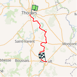
Trail Road bike of 30 km to be discovered at New Aquitaine, Deux-Sèvres, Saint-Jean-de-Thouars. This trail is proposed by olaze.
Description
Circuit de la "Vélo Francette" de Thouars à Availles , 30 Km .
Sur chemins et petites routes .Petits villages sympas .
Il y a de bonnes montées ...!!!
Positioning
Country:
France
Region :
New Aquitaine
Department/Province :
Deux-Sèvres
Municipality :
Saint-Jean-de-Thouars
Location:
Unknown
Start:(Dec)
Start:(UTM)
712462 ; 5205934 (30T) N.
Comments
Trails nearby
![Trail Walking Thouars - DEUX-SEVRES / THOUARS: CASCADE DE POMMIERS (Ruisseau du Presssoir) - Photo](https://media.geolcdn.com/t/375/260/1fef342e-da0b-4d13-af3b-9b142096ee93.jpg&format=jpg&maxdim=2)
![Walking Walking](https://static1.geolcdn.com/sitytour/trail-icons/101.png)
DEUX-SEVRES / THOUARS: CASCADE DE POMMIERS (Ruisseau du Presssoir)
Walking
Easy
Thouars,
New Aquitaine,
Deux-Sèvres,
France
![](/images/other/stat-length.png)
5.6 km | 6.8 km-effort
1h 32min
![](https://static1.geolcdn.com/siteimages/upload/files/16400158638029165_repeat_loop_refresh_sync_direction_icon.png)
Yes
![Trail Walking Thouars - randonnée cascade de pommier PR10 - Photo](https://media.geolcdn.com/t/375/260/029185ff-d87c-4bc9-a318-095a898b87d1.jpg&format=jpg&maxdim=2)
![Walking Walking](https://static1.geolcdn.com/sitytour/trail-icons/101.png)
randonnée cascade de pommier PR10
Walking
Medium
Thouars,
New Aquitaine,
Deux-Sèvres,
France
![](/images/other/stat-length.png)
2.9 km | 3.8 km-effort
1h 35min
![](https://static1.geolcdn.com/siteimages/upload/files/16400158638029165_repeat_loop_refresh_sync_direction_icon.png)
Yes
![Trail Road bike Saint-Jean-de-Thouars - thouars-saumur-rigny usse-Thouars - Photo](https://media.geolcdn.com/t/375/260/ext.jpg?maxdim=2&url=https%3A%2F%2Fstatic1.geolcdn.com%2Fsiteimages%2Fupload%2Ffiles%2F1524743154velo.jpg)
![Road bike Road bike](https://static1.geolcdn.com/sitytour/trail-icons/201.png)
thouars-saumur-rigny usse-Thouars
Road bike
Very easy
Saint-Jean-de-Thouars,
New Aquitaine,
Deux-Sèvres,
France
![](/images/other/stat-length.png)
168 km | 187 km-effort
16h 54min
![](https://static1.geolcdn.com/siteimages/upload/files/16400158638029165_repeat_loop_refresh_sync_direction_icon.png)
Yes
![Trail Mountain bike Thouars - F.ThouarsParthenay.J7/14 - Photo](https://media.geolcdn.com/t/375/260/ext.jpg?maxdim=2&url=https%3A%2F%2Fstatic1.geolcdn.com%2Fsiteimages%2Fupload%2Ffiles%2F1524743154velo.jpg)
![Mountain bike Mountain bike](https://static1.geolcdn.com/sitytour/trail-icons/202.png)
F.ThouarsParthenay.J7/14
Mountain bike
Very easy
Thouars,
New Aquitaine,
Deux-Sèvres,
France
![](/images/other/stat-length.png)
68 km | 79 km-effort
5min
![](https://static1.geolcdn.com/siteimages/upload/files/16400158638029165_repeat_loop_refresh_sync_direction_icon.png)
No
![Trail Cycle Thouars - Thouars Airvault V2 - Photo](https://media.geolcdn.com/t/375/260/ext.jpg?maxdim=2&url=https%3A%2F%2Fstatic1.geolcdn.com%2Fsiteimages%2Fupload%2Ffiles%2F1524743154velo.jpg)
![Cycle Cycle](https://static1.geolcdn.com/sitytour/trail-icons/200.png)
Thouars Airvault V2
Cycle
Medium
Thouars,
New Aquitaine,
Deux-Sèvres,
France
![](/images/other/stat-length.png)
21 km | 24 km-effort
2h 2min
![](https://static1.geolcdn.com/siteimages/upload/files/16400158638029165_repeat_loop_refresh_sync_direction_icon.png)
No
![Trail Cycle Thouars - Thouars Airvault - Photo](https://media.geolcdn.com/t/375/260/ext.jpg?maxdim=2&url=https%3A%2F%2Fstatic1.geolcdn.com%2Fsiteimages%2Fupload%2Ffiles%2F1524743154velo.jpg)
![Cycle Cycle](https://static1.geolcdn.com/sitytour/trail-icons/200.png)
Thouars Airvault
Cycle
Medium
Thouars,
New Aquitaine,
Deux-Sèvres,
France
![](/images/other/stat-length.png)
30 km | 35 km-effort
2h 2min
![](https://static1.geolcdn.com/siteimages/upload/files/16400158638029165_repeat_loop_refresh_sync_direction_icon.png)
No
![Trail Walking Thouars - velofrancette étape 15 - Photo](https://media.geolcdn.com/t/375/260/ext.jpg?maxdim=2&url=https%3A%2F%2Fstatic1.geolcdn.com%2Fsiteimages%2Fupload%2Ffiles%2F1553511878bg_sport_marche.png)
![Walking Walking](https://static1.geolcdn.com/sitytour/trail-icons/101.png)
velofrancette étape 15
Walking
Easy
Thouars,
New Aquitaine,
Deux-Sèvres,
France
![](/images/other/stat-length.png)
30 km | 34 km-effort
Unknown
![](https://static1.geolcdn.com/siteimages/upload/files/16400158638029165_repeat_loop_refresh_sync_direction_icon.png)
No
![Trail Cycle Thouars - etape 15 - Photo](https://media.geolcdn.com/t/375/260/ext.jpg?maxdim=2&url=https%3A%2F%2Fstatic1.geolcdn.com%2Fsiteimages%2Fupload%2Ffiles%2F1524743154velo.jpg)
![Cycle Cycle](https://static1.geolcdn.com/sitytour/trail-icons/200.png)
etape 15
Cycle
Very easy
Thouars,
New Aquitaine,
Deux-Sèvres,
France
![](/images/other/stat-length.png)
30 km | 34 km-effort
Unknown
![](https://static1.geolcdn.com/siteimages/upload/files/16400158638029165_repeat_loop_refresh_sync_direction_icon.png)
No
![Trail Walking Thouars - SOULBROIS - Photo](https://media.geolcdn.com/t/375/260/ext.jpg?maxdim=2&url=https%3A%2F%2Fstatic1.geolcdn.com%2Fsiteimages%2Fupload%2Ffiles%2F1553511878bg_sport_marche.png)
![Walking Walking](https://static1.geolcdn.com/sitytour/trail-icons/101.png)
SOULBROIS
Walking
Very easy
Thouars,
New Aquitaine,
Deux-Sèvres,
France
![](/images/other/stat-length.png)
8.1 km | 8.8 km-effort
1h 57min
![](https://static1.geolcdn.com/siteimages/upload/files/16400158638029165_repeat_loop_refresh_sync_direction_icon.png)
Yes