![](/images/other/stat-length.png)
![Trail Walking Saint-Cézaire-sur-Siagne - Var - Gorges de la Siagne - St Cézaire - pont des Tuves - Chapelle St Saturnin - Photo](https://media.geolcdn.com/t/1900/400/c3d4333b-03d9-4b97-947d-a3e555ebbdb9.jpg&format=pjpeg&maxdim=2)
Var - Gorges de la Siagne - St Cézaire - pont des Tuves - Chapelle St Saturnin
Bart2015
User
![Length](/images/other/stat-length.png)
Length
16.2 km
![Max alt](https://static1.geolcdn.com/siteimages/upload/files/1508320355ic_sort_altitude_max_24dp.png)
Max alt
490 m
![Uphill gradient](https://static1.geolcdn.com/siteimages/upload/files/1508320355ic_sort_den_pos_24dp.png)
Uphill gradient
744 m
![Km-Effort](/images/other/stat-length.png)
Km-Effort
26 km
![Min alt](https://static1.geolcdn.com/siteimages/upload/files/1508320355ic_sort_altitude_min_24dp.png)
Min alt
169 m
![Downhill gradient](https://static1.geolcdn.com/siteimages/upload/files/1508320355ic_sort_den_neg_24dp.png)
Downhill gradient
752 m
![Boucle](https://static1.geolcdn.com/siteimages/upload/files/16400158638029165_repeat_loop_refresh_sync_direction_icon.png)
Boucle
Yes
Creation date :
2019-05-18 09:05:38.531
Updated on :
2019-05-18 15:01:25.459
![Walking](https://static1.geolcdn.com/sitytour/trail-icons/101.png)
4h30
Difficulty : Difficult
![Scan this QR Code to open this trail in the SityTrail application](https://capi.geolives.com/qq0zvz2zws4bq2lad0pu/sitytour/trails/2087141/qr.png?size=200)
FREE GPS app for hiking
About
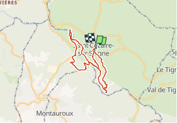
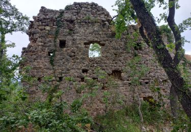
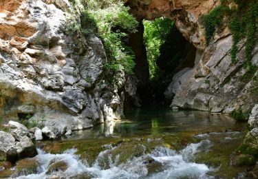
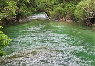
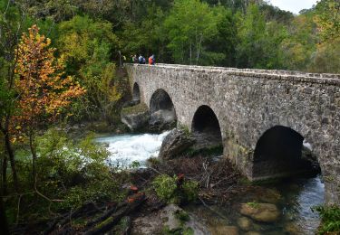
Trail Walking of 16.2 km to be discovered at Provence-Alpes-Côte d'Azur, Maritime Alps, Saint-Cézaire-sur-Siagne. This trail is proposed by Bart2015.
Description
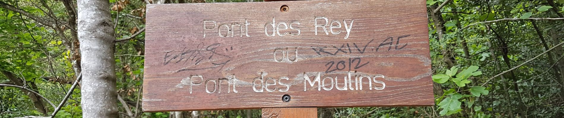
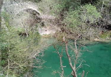
Belle balade sur chemins ombragés anciens. Circuit à revoir : descendre au pont de Rey depuis St Cézaire au départ
Positioning
Country:
France
Region :
Provence-Alpes-Côte d'Azur
Department/Province :
Maritime Alps
Municipality :
Saint-Cézaire-sur-Siagne
Location:
Unknown
Start:(Dec)
Start:(UTM)
322036 ; 4835286 (32T) N.
Comments
Trails nearby
![Trail On foot Tanneron - La chapelle de St Cassien des bois, le pont détruit et au fil de l'eau - Photo](https://media.geolcdn.com/t/375/260/a22ee1a2-3869-418b-b8c3-03abedec3efc.jpg&format=jpg&maxdim=2)
![On foot On foot](https://static1.geolcdn.com/sitytour/trail-icons/100.png)
La chapelle de St Cassien des bois, le pont détruit et au fil de l'eau
On foot
Easy
(5)
Tanneron,
Provence-Alpes-Côte d'Azur,
Var,
France
![](/images/other/stat-length.png)
7.3 km | 10.3 km-effort
2h 19min
![](https://static1.geolcdn.com/siteimages/upload/files/16400158638029165_repeat_loop_refresh_sync_direction_icon.png)
Yes
![Trail Walking Montauroux - Monteroux Gorges de la Siagne 04.04.2015 - Photo](https://media.geolcdn.com/t/375/260/ext.jpg?maxdim=2&url=https%3A%2F%2Fservices.sitytrail.com%2FGeolivesWS%2FDownloadMedia.ashx%3FTrailID%3D404141%26Media%3Dfix__20150404125312.jpg)
![Walking Walking](https://static1.geolcdn.com/sitytour/trail-icons/101.png)
Monteroux Gorges de la Siagne 04.04.2015
Walking
Easy
(1)
Montauroux,
Provence-Alpes-Côte d'Azur,
Var,
France
![](/images/other/stat-length.png)
11.8 km | 16.4 km-effort
3h 26min
![](https://static1.geolcdn.com/siteimages/upload/files/16400158638029165_repeat_loop_refresh_sync_direction_icon.png)
Yes
![Trail On foot Le Tignet - Val de Siagne - Photo](https://media.geolcdn.com/t/375/260/876dd6c7-0972-4635-aa2a-412c508ab044.jpeg&format=jpg&maxdim=2)
![On foot On foot](https://static1.geolcdn.com/sitytour/trail-icons/100.png)
Val de Siagne
On foot
Easy
Le Tignet,
Provence-Alpes-Côte d'Azur,
Maritime Alps,
France
![](/images/other/stat-length.png)
6.5 km | 9.5 km-effort
2h 9min
![](https://static1.geolcdn.com/siteimages/upload/files/16400158638029165_repeat_loop_refresh_sync_direction_icon.png)
Yes
![Trail Walking Saint-Cézaire-sur-Siagne - Col de Cabris - Photo](https://media.geolcdn.com/t/375/260/ext.jpg?maxdim=2&url=https%3A%2F%2Fstatic1.geolcdn.com%2Fsiteimages%2Fupload%2Ffiles%2F1553511878bg_sport_marche.png)
![Walking Walking](https://static1.geolcdn.com/sitytour/trail-icons/101.png)
Col de Cabris
Walking
Easy
(1)
Saint-Cézaire-sur-Siagne,
Provence-Alpes-Côte d'Azur,
Maritime Alps,
France
![](/images/other/stat-length.png)
7.3 km | 9.7 km-effort
3h 0min
![](https://static1.geolcdn.com/siteimages/upload/files/16400158638029165_repeat_loop_refresh_sync_direction_icon.png)
Yes
![Trail Walking Saint-Cézaire-sur-Siagne - st cezaire siagne - Photo](https://media.geolcdn.com/t/375/260/ext.jpg?maxdim=2&url=https%3A%2F%2Fstatic1.geolcdn.com%2Fsiteimages%2Fupload%2Ffiles%2F1553511878bg_sport_marche.png)
![Walking Walking](https://static1.geolcdn.com/sitytour/trail-icons/101.png)
st cezaire siagne
Walking
Very easy
(1)
Saint-Cézaire-sur-Siagne,
Provence-Alpes-Côte d'Azur,
Maritime Alps,
France
![](/images/other/stat-length.png)
6.9 km | 11.4 km-effort
2h 42min
![](https://static1.geolcdn.com/siteimages/upload/files/16400158638029165_repeat_loop_refresh_sync_direction_icon.png)
No
![Trail Walking Callian - Callian, ruines de Velnasque - Photo](https://media.geolcdn.com/t/375/260/f3797b20-4f1a-42d8-b8ed-35468ec43e4e.jpg&format=jpg&maxdim=2)
![Walking Walking](https://static1.geolcdn.com/sitytour/trail-icons/101.png)
Callian, ruines de Velnasque
Walking
Medium
Callian,
Provence-Alpes-Côte d'Azur,
Var,
France
![](/images/other/stat-length.png)
13.7 km | 18.3 km-effort
6h 1min
![](https://static1.geolcdn.com/siteimages/upload/files/16400158638029165_repeat_loop_refresh_sync_direction_icon.png)
No
![Walking Walking](https://static1.geolcdn.com/sitytour/trail-icons/101.png)
St Vallier de Thiey - Col de la Lèque - Chapelle St Jean - Arche Ponadieu
Walking
Medium
Saint-Vallier-de-Thiey,
Provence-Alpes-Côte d'Azur,
Maritime Alps,
France
![](/images/other/stat-length.png)
14.1 km | 21 km-effort
4h 44min
![](https://static1.geolcdn.com/siteimages/upload/files/16400158638029165_repeat_loop_refresh_sync_direction_icon.png)
Yes
![Trail Walking Saint-Cézaire-sur-Siagne - Le canal et la rivière de la Siagne - Photo](https://media.geolcdn.com/t/375/260/8dec3c8f-da07-4204-a170-c1946b688755.jpg&format=jpg&maxdim=2)
![Walking Walking](https://static1.geolcdn.com/sitytour/trail-icons/101.png)
Le canal et la rivière de la Siagne
Walking
Medium
Saint-Cézaire-sur-Siagne,
Provence-Alpes-Côte d'Azur,
Maritime Alps,
France
![](/images/other/stat-length.png)
8.4 km | 13.9 km-effort
3h 8min
![](https://static1.geolcdn.com/siteimages/upload/files/16400158638029165_repeat_loop_refresh_sync_direction_icon.png)
Yes
![Walking Walking](https://static1.geolcdn.com/sitytour/trail-icons/101.png)
Saint Cézaire sur Siagne - Pont des Tuves - Chapelle St Saturnin
Walking
Medium
Saint-Cézaire-sur-Siagne,
Provence-Alpes-Côte d'Azur,
Maritime Alps,
France
![](/images/other/stat-length.png)
13.6 km | 19.9 km-effort
4h 30min
![](https://static1.geolcdn.com/siteimages/upload/files/16400158638029165_repeat_loop_refresh_sync_direction_icon.png)
Yes