![](/images/other/stat-length.png)
![Trail Walking Grasse - 20190517. Grasse, le centre historique à pied. - Photo](https://media.geolcdn.com/t/1900/400/34decc08-7b67-471b-923a-bfd31c4521ab.jpg&format=pjpeg&maxdim=2)
20190517. Grasse, le centre historique à pied.
hal2012
User
![Length](/images/other/stat-length.png)
Length
3.7 km
![Max alt](https://static1.geolcdn.com/siteimages/upload/files/1508320355ic_sort_altitude_max_24dp.png)
Max alt
348 m
![Uphill gradient](https://static1.geolcdn.com/siteimages/upload/files/1508320355ic_sort_den_pos_24dp.png)
Uphill gradient
51 m
![Km-Effort](/images/other/stat-length.png)
Km-Effort
4.3 km
![Min alt](https://static1.geolcdn.com/siteimages/upload/files/1508320355ic_sort_altitude_min_24dp.png)
Min alt
312 m
![Downhill gradient](https://static1.geolcdn.com/siteimages/upload/files/1508320355ic_sort_den_neg_24dp.png)
Downhill gradient
49 m
![Boucle](https://static1.geolcdn.com/siteimages/upload/files/16400158638029165_repeat_loop_refresh_sync_direction_icon.png)
Boucle
Yes
Creation date :
2019-05-17 10:25:21.906
Updated on :
2019-05-17 15:38:12.045
![Walking](https://static1.geolcdn.com/sitytour/trail-icons/101.png)
3h24
Difficulty : Very easy
![Scan this QR Code to open this trail in the SityTrail application](https://capi.geolives.com/qq0zvz2zws4bq2lad0pu/sitytour/trails/2086308/qr.png?size=200)
FREE GPS app for hiking
About
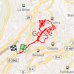
Trail Walking of 3.7 km to be discovered at Provence-Alpes-Côte d'Azur, Maritime Alps, Grasse. This trail is proposed by hal2012.
Description
Grasse parking juste avant le 1er park souterrain 12h20...
5.10€...
Début marche 12h25
...
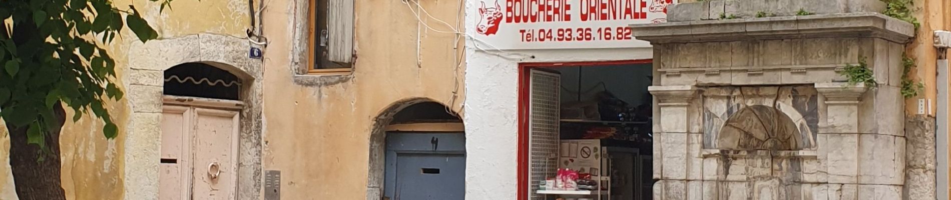
Petit Resto tunisien place Jean Jaures
15h40...16h12
2 kebabs
10€
Depart vers voiture 16h12
Voiture 16h20.
Positioning
Country:
France
Region :
Provence-Alpes-Côte d'Azur
Department/Province :
Maritime Alps
Municipality :
Grasse
Location:
Unknown
Start:(Dec)
Start:(UTM)
332321 ; 4835844 (32T) N.
Comments
Trails nearby
![Trail Walking Grasse - petit rando au dessus de Grasse - Photo](https://media.geolcdn.com/t/375/260/ext.jpg?maxdim=2&url=https%3A%2F%2Fservices.sitytrail.com%2FGeolivesWS%2FDownloadMedia.ashx%3FTrailID%3D219692%26Media%3Dfix__20130907100916.jpg)
![Walking Walking](https://static1.geolcdn.com/sitytour/trail-icons/101.png)
petit rando au dessus de Grasse
Walking
Medium
(1)
Grasse,
Provence-Alpes-Côte d'Azur,
Maritime Alps,
France
![](/images/other/stat-length.png)
6 km | 10.6 km-effort
1h 55min
![](https://static1.geolcdn.com/siteimages/upload/files/16400158638029165_repeat_loop_refresh_sync_direction_icon.png)
Yes
![Trail Walking Le Bar-sur-Loup - rando - Photo](https://media.geolcdn.com/t/375/260/fa0ef731-2bd1-40ee-a714-99f05472c6fe.jpg&format=jpg&maxdim=2)
![Walking Walking](https://static1.geolcdn.com/sitytour/trail-icons/101.png)
rando
Walking
Very difficult
Le Bar-sur-Loup,
Provence-Alpes-Côte d'Azur,
Maritime Alps,
France
![](/images/other/stat-length.png)
12.1 km | 21 km-effort
6h 9min
![](https://static1.geolcdn.com/siteimages/upload/files/16400158638029165_repeat_loop_refresh_sync_direction_icon.png)
No
![Trail On foot Le Bar-sur-Loup - Circuit de la Malle - Photo](https://media.geolcdn.com/t/375/260/9cf230aa-9298-45ef-9b30-612a3965bbab.jpeg&format=jpg&maxdim=2)
![On foot On foot](https://static1.geolcdn.com/sitytour/trail-icons/100.png)
Circuit de la Malle
On foot
Difficult
Le Bar-sur-Loup,
Provence-Alpes-Côte d'Azur,
Maritime Alps,
France
![](/images/other/stat-length.png)
22 km | 34 km-effort
7h 43min
![](https://static1.geolcdn.com/siteimages/upload/files/16400158638029165_repeat_loop_refresh_sync_direction_icon.png)
Yes
![Trail On foot Grasse - Tour de la Marbrière - Photo](https://media.geolcdn.com/t/375/260/75605552-a463-425d-8862-67e7b2a12a52.jpeg&format=jpg&maxdim=2)
![On foot On foot](https://static1.geolcdn.com/sitytour/trail-icons/100.png)
Tour de la Marbrière
On foot
Easy
Grasse,
Provence-Alpes-Côte d'Azur,
Maritime Alps,
France
![](/images/other/stat-length.png)
5.5 km | 10 km-effort
2h 16min
![](https://static1.geolcdn.com/siteimages/upload/files/16400158638029165_repeat_loop_refresh_sync_direction_icon.png)
Yes
![Trail Mountain bike Grasse - vttour_2051 - Photo](https://media.geolcdn.com/t/375/260/ext.jpg?maxdim=2&url=https%3A%2F%2Fstatic1.geolcdn.com%2Fsiteimages%2Fupload%2Ffiles%2F1524743154velo.jpg)
![Mountain bike Mountain bike](https://static1.geolcdn.com/sitytour/trail-icons/202.png)
vttour_2051
Mountain bike
Medium
(1)
Grasse,
Provence-Alpes-Côte d'Azur,
Maritime Alps,
France
![](/images/other/stat-length.png)
18.5 km | 27 km-effort
1h 42min
![](https://static1.geolcdn.com/siteimages/upload/files/16400158638029165_repeat_loop_refresh_sync_direction_icon.png)
Yes
![Trail Walking Cabris - Dolmen, Pierre Druidique, Croix de Cabris - Photo](https://media.geolcdn.com/t/375/260/4b767dba-740e-4559-afb3-0d66746a5ec7.jpg&format=jpg&maxdim=2)
![Walking Walking](https://static1.geolcdn.com/sitytour/trail-icons/101.png)
Dolmen, Pierre Druidique, Croix de Cabris
Walking
Medium
Cabris,
Provence-Alpes-Côte d'Azur,
Maritime Alps,
France
![](/images/other/stat-length.png)
13.6 km | 17.3 km-effort
3h 56min
![](https://static1.geolcdn.com/siteimages/upload/files/16400158638029165_repeat_loop_refresh_sync_direction_icon.png)
Yes
![Trail sport Mougins - Le long du canal de la Siagne (une partie) - Photo](https://media.geolcdn.com/t/375/260/4d0c3f2a-5e8d-470f-a038-a129b60e8cd6.jpg&format=jpg&maxdim=2)
Le long du canal de la Siagne (une partie)
sport
Very easy
Mougins,
Provence-Alpes-Côte d'Azur,
Maritime Alps,
France
![](/images/other/stat-length.png)
6.6 km | 7.9 km-effort
Unknown
![](https://static1.geolcdn.com/siteimages/upload/files/16400158638029165_repeat_loop_refresh_sync_direction_icon.png)
Yes
![Trail Walking Grasse - La croix de Cbris - Photo](https://media.geolcdn.com/t/375/260/859a1953-c561-4841-95a2-a09128886754.jpg&format=jpg&maxdim=2)
![Walking Walking](https://static1.geolcdn.com/sitytour/trail-icons/101.png)
La croix de Cbris
Walking
Easy
Grasse,
Provence-Alpes-Côte d'Azur,
Maritime Alps,
France
![](/images/other/stat-length.png)
14.1 km | 19 km-effort
5h 40min
![](https://static1.geolcdn.com/siteimages/upload/files/16400158638029165_repeat_loop_refresh_sync_direction_icon.png)
Yes
![Trail Walking Saint-Vallier-de-Thiey - Col du Pilon : Colle maçon et haut Montet - Photo](https://media.geolcdn.com/t/375/260/1f50f7c4-1c1b-4b0f-8895-c647368ee7d1.jpg&format=jpg&maxdim=2)
![Walking Walking](https://static1.geolcdn.com/sitytour/trail-icons/101.png)
Col du Pilon : Colle maçon et haut Montet
Walking
Very difficult
Saint-Vallier-de-Thiey,
Provence-Alpes-Côte d'Azur,
Maritime Alps,
France
![](/images/other/stat-length.png)
23 km | 38 km-effort
8h 37min
![](https://static1.geolcdn.com/siteimages/upload/files/16400158638029165_repeat_loop_refresh_sync_direction_icon.png)
Yes