Trail Walking Esparron - 20190507_Espréaux_Tête des Quarante - Photo

20190507_Espréaux_Tête des Quarante

© OpenStreetMap contributors
Length
Length
15 km
Max alt
Max alt
1560 m
Uphill gradient
Uphill gradient
984 m
Km-Effort
Km-Effort  
28 km
Min alt
Min alt
991 m
Downhill gradient
Downhill gradient
985 m
Boucle
Boucle
Yes
Creation date :
2019-05-16 06:48:30.663
Updated on :
2019-05-28 19:49:32.264

(0 Reviews)

Walking
Walking
5h39
Difficulty : Medium

Scan this QR Code to open this trail in the SityTrail application

FREE GPS app for hiking

Logo SityTrail SityTrail

IGN / Geographical institutes

Download SityTrail from the App Store Download SityTrail from Google Play

Logo SityTrail SityTrail World

The world is yours!

Download SityTrail from the App Store Download SityTrail from Google Play Download SityTrail on Huawei AppGallery

About

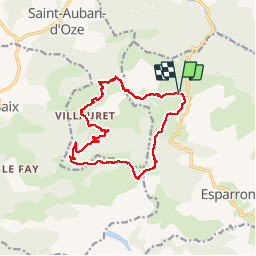
Trail Walking of 15 km to be discovered at Provence-Alpes-Côte d'Azur, Hautes-Alpes, Esparron. This trail is proposed by PapouBertrand.

Description

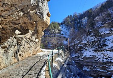
Attention, jolie rando mais très mal balisée sur la montée à la tête des quarante. La végétation a envahi le sentier qui est parfois introuvable et inutilisable en particulier au niveau du clôt Corbeau.

Elevation profile

Photos

Positioning

Country:
France
Region :
Provence-Alpes-Côte d'Azur
Department/Province :
Hautes-Alpes
Municipality :
Esparron
Location:
Unknown
Start:(UTM)
729513 ; 4929028 (31T) N.

Trails nearby

Trail Walking Le Saix - R08 La boucle des cascades jaunes - Photo
Walking
GUIDE+

Walking

Very easy
(1)
Le Saix, Provence-Alpes-Côte d'Azur, Hautes-Alpes, France
5.5 km | 10.3 km-effort
2h 10min
Yes
Trail Walking Manteyer - R14   Pic de Ceuze - Photo
Walking
GUIDE+

Walking

Medium
(5)
Manteyer, Provence-Alpes-Côte d'Azur, Hautes-Alpes, France
9.6 km | 15.6 km-effort
4h 30min
Yes
Trail Walking Le Saix - R07   le fai - Photo
Walking
GUIDE+

Walking

Easy
(4)
Le Saix, Provence-Alpes-Côte d'Azur, Hautes-Alpes, France
5.1 km | 8 km-effort
1h 42min
Yes
Trail Mountain bike Manteyer - VTT32   aspremont - Photo
Mountain bike
GUIDE+

Mountain bike

Medium
(2)
Manteyer, Provence-Alpes-Côte d'Azur, Hautes-Alpes, France
21 km | 28 km-effort
2h 8min
No
Trail Mountain bike Châteauneuf-d'Oze - ceuse9 avril 2012 - Photo
Mountain bike
GUIDE
harydh

Mountain bike

Medium
(2)
Châteauneuf-d'Oze, Provence-Alpes-Côte d'Azur, Hautes-Alpes, France
18.1 km | 26 km-effort
Unknown
Yes
Trail Trail Châteauneuf-d'Oze - Tour et sommet petite Céüse - Photo
Trail
GUIDE
nadd73

Trail

Medium
Châteauneuf-d'Oze, Provence-Alpes-Côte d'Azur, Hautes-Alpes, France
11.8 km | 22 km-effort
2h 10min
Yes
Trail Walking Sigoyer - corniche de Ceüze tour - Photo
Walking
GUIDE
nadd73

Walking

Medium
Sigoyer, Provence-Alpes-Côte d'Azur, Hautes-Alpes, France
15.7 km | 28 km-effort
4h 13min
Yes
Trail Walking Le Saix - Lac de Peyssier - Photo
Walking
GUIDE
Marco05

Walking

Medium
Le Saix, Provence-Alpes-Côte d'Azur, Hautes-Alpes, France
12.8 km | 19.6 km-effort
4h 27min
Yes
Trail Walking Manteyer - Tour de Ceüze - Photo
Walking
GUIDE
Marco05

Walking

Difficult
Manteyer, Provence-Alpes-Côte d'Azur, Hautes-Alpes, France
11.2 km | 20 km-effort
4h 34min
Yes


Close
My subscriptions