![](/images/other/stat-length.png)
![Trail Walking Saint-Georges - La rando de St GEORGES 16700 - Photo](https://media.geolcdn.com/t/1900/400/1d597a4f-095d-4caa-8712-86d5fd005113.jpg&format=pjpeg&maxdim=2)
La rando de St GEORGES 16700
alainjoseph6
User
![Length](/images/other/stat-length.png)
Length
7.9 km
![Max alt](https://static1.geolcdn.com/siteimages/upload/files/1508320355ic_sort_altitude_max_24dp.png)
Max alt
125 m
![Uphill gradient](https://static1.geolcdn.com/siteimages/upload/files/1508320355ic_sort_den_pos_24dp.png)
Uphill gradient
78 m
![Km-Effort](/images/other/stat-length.png)
Km-Effort
8.9 km
![Min alt](https://static1.geolcdn.com/siteimages/upload/files/1508320355ic_sort_altitude_min_24dp.png)
Min alt
85 m
![Downhill gradient](https://static1.geolcdn.com/siteimages/upload/files/1508320355ic_sort_den_neg_24dp.png)
Downhill gradient
75 m
![Boucle](https://static1.geolcdn.com/siteimages/upload/files/16400158638029165_repeat_loop_refresh_sync_direction_icon.png)
Boucle
Yes
Creation date :
2019-05-16 12:16:27.91
Updated on :
2019-05-16 14:46:15.17
![Walking](https://static1.geolcdn.com/sitytour/trail-icons/101.png)
2h28
Difficulty : Easy
![Scan this QR Code to open this trail in the SityTrail application](https://capi.geolives.com/qq0zvz2zws4bq2lad0pu/sitytour/trails/2085221/qr.png?size=200)
FREE GPS app for hiking
About
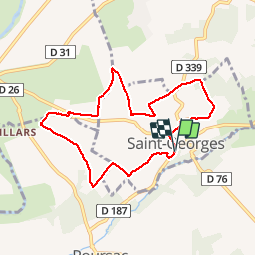
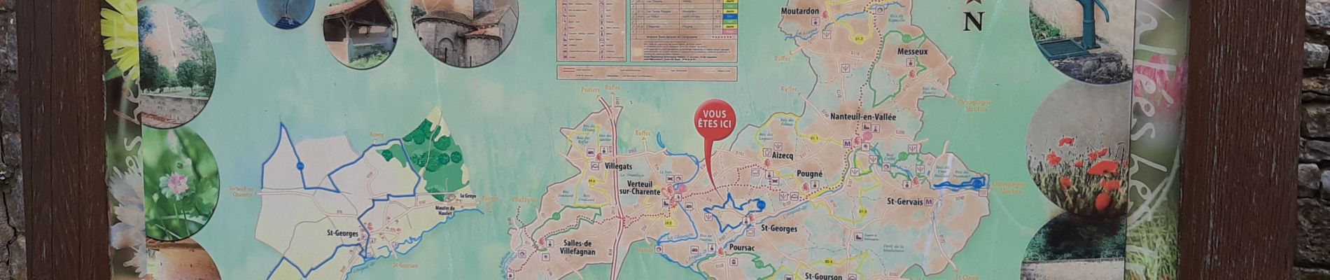
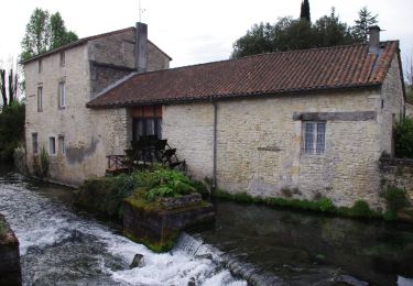
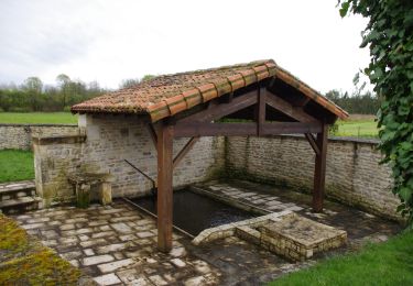
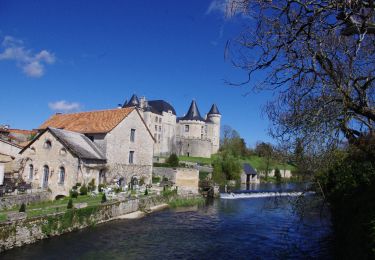
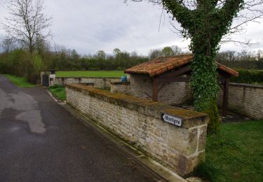
Trail Walking of 7.9 km to be discovered at New Aquitaine, Charente, Saint-Georges. This trail is proposed by alainjoseph6.
Description
Une magnifique randonnée très venteuse avec des paysages à perte de vue. Nous avons cheminé au milieu des champs des céréales entourés d'une trentaine d'éoliennes.
Positioning
Country:
France
Region :
New Aquitaine
Department/Province :
Charente
Municipality :
Saint-Georges
Location:
Unknown
Start:(Dec)
Start:(UTM)
288558 ; 5094564 (31T) N.
Comments
Trails nearby
![Trail Hybrid bike Condac - rejellant chassane - Photo](https://media.geolcdn.com/t/375/260/f941dbf9-6f50-4e7d-8c40-12817a339d98.jpg&format=jpg&maxdim=2)
![Hybrid bike Hybrid bike](https://static1.geolcdn.com/sitytour/trail-icons/203.png)
rejellant chassane
Hybrid bike
Easy
Condac,
New Aquitaine,
Charente,
France
![](/images/other/stat-length.png)
17.5 km | 19.6 km-effort
5h 11min
![](https://static1.geolcdn.com/siteimages/upload/files/16400158638029165_repeat_loop_refresh_sync_direction_icon.png)
No
![Trail Mountain bike Nanteuil-en-Vallée - Nanteuil en Vallée Rejalland - Photo](https://media.geolcdn.com/t/375/260/12bae749-b8f9-4a15-853b-414ebee69930.jpg&format=jpg&maxdim=2)
![Mountain bike Mountain bike](https://static1.geolcdn.com/sitytour/trail-icons/202.png)
Nanteuil en Vallée Rejalland
Mountain bike
Medium
Nanteuil-en-Vallée,
New Aquitaine,
Charente,
France
![](/images/other/stat-length.png)
22 km | 25 km-effort
2h 2min
![](https://static1.geolcdn.com/siteimages/upload/files/16400158638029165_repeat_loop_refresh_sync_direction_icon.png)
No
![Trail Walking Condac - Condac - Photo](https://media.geolcdn.com/t/375/260/ext.jpg?maxdim=2&url=https%3A%2F%2Fservices.sitytrail.com%2FGeolivesWS%2FDownloadMedia.ashx%3FTrailID%3D556317%26Media%3Ddcadb249-373c-4f07-b689-15b2cfca5ca5.JPG)
![Walking Walking](https://static1.geolcdn.com/sitytour/trail-icons/101.png)
![Trail Walking Condac - Condac_Bioussac_Barro - Photo](https://media.geolcdn.com/t/375/260/ext.jpg?maxdim=2&url=https%3A%2F%2Fservices.sitytrail.com%2FGeolivesWS%2FDownloadMedia.ashx%3FTrailID%3D554281%26Media%3Dad2440e1-83f4-4ca4-9ca5-3c359047fce4.JPG)
![Walking Walking](https://static1.geolcdn.com/sitytour/trail-icons/101.png)
Condac_Bioussac_Barro
Walking
Medium
Condac,
New Aquitaine,
Charente,
France
![](/images/other/stat-length.png)
26 km | 31 km-effort
6h 40min
![](https://static1.geolcdn.com/siteimages/upload/files/16400158638029165_repeat_loop_refresh_sync_direction_icon.png)
Yes
![Trail Walking Verteuil-sur-Charente - Verteuil sur Charente - Photo](https://media.geolcdn.com/t/375/260/ext.jpg?maxdim=2&url=https%3A%2F%2Fservices.sitytrail.com%2FGeolivesWS%2FDownloadMedia.ashx%3FTrailID%3D541908%26Media%3Dda727876-5325-4d5b-8f4e-2db3bae94bb3.JPG)
![Walking Walking](https://static1.geolcdn.com/sitytour/trail-icons/101.png)
Verteuil sur Charente
Walking
Easy
Verteuil-sur-Charente,
New Aquitaine,
Charente,
France
![](/images/other/stat-length.png)
6.6 km | 7.4 km-effort
1h 40min
![](https://static1.geolcdn.com/siteimages/upload/files/16400158638029165_repeat_loop_refresh_sync_direction_icon.png)
Yes
![Trail Walking Nanteuil-en-Vallée - Nanteuil_Condac - Photo](https://media.geolcdn.com/t/375/260/ext.jpg?maxdim=2&url=https%3A%2F%2Fservices.sitytrail.com%2FGeolivesWS%2FDownloadMedia.ashx%3FTrailID%3D541902%26Media%3Df24d0504-a5d7-450c-82bb-91e8baa267fc.JPG)
![Walking Walking](https://static1.geolcdn.com/sitytour/trail-icons/101.png)
Nanteuil_Condac
Walking
Medium
Nanteuil-en-Vallée,
New Aquitaine,
Charente,
France
![](/images/other/stat-length.png)
26 km | 31 km-effort
7h 0min
![](https://static1.geolcdn.com/siteimages/upload/files/16400158638029165_repeat_loop_refresh_sync_direction_icon.png)
Yes
![Trail Walking Nanteuil-en-Vallée - Monts et vallées de ll'Argentor - Photo](https://media.geolcdn.com/t/375/260/ext.jpg?maxdim=2&url=https%3A%2F%2Fstatic1.geolcdn.com%2Fsiteimages%2Fupload%2Ffiles%2F1553511878bg_sport_marche.png)
![Walking Walking](https://static1.geolcdn.com/sitytour/trail-icons/101.png)
Monts et vallées de ll'Argentor
Walking
Easy
Nanteuil-en-Vallée,
New Aquitaine,
Charente,
France
![](/images/other/stat-length.png)
11.6 km | 14.5 km-effort
3h 0min
![](https://static1.geolcdn.com/siteimages/upload/files/16400158638029165_repeat_loop_refresh_sync_direction_icon.png)
Yes
![Trail Walking Barro - Barro - Photo](https://media.geolcdn.com/t/375/260/ext.jpg?maxdim=2&url=https%3A%2F%2Fstatic1.geolcdn.com%2Fsiteimages%2Fupload%2Ffiles%2F1553511878bg_sport_marche.png)
![Walking Walking](https://static1.geolcdn.com/sitytour/trail-icons/101.png)
![Trail Walking Poursac - Poursac - Photo](https://media.geolcdn.com/t/375/260/ext.jpg?maxdim=2&url=https%3A%2F%2Fstatic1.geolcdn.com%2Fsiteimages%2Fupload%2Ffiles%2F1553511878bg_sport_marche.png)
![Walking Walking](https://static1.geolcdn.com/sitytour/trail-icons/101.png)