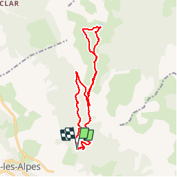
![](/images/other/stat-length.png)
![Trail Walking Seyne - Lacs noir et du milieu - Photo](https://media.geolcdn.com/t/1900/400/ext.pjpeg?maxdim=2&url=https%3A%2F%2Fservices.sitytrail.com%2FGeolivesWS%2FDownloadMedia.ashx%3FTrailID%3D208385%26Media%3D20130728114816.jpg)
Lacs noir et du milieu
vmarie12
User
![Length](/images/other/stat-length.png)
![Max alt](https://static1.geolcdn.com/siteimages/upload/files/1508320355ic_sort_altitude_max_24dp.png)
![Uphill gradient](https://static1.geolcdn.com/siteimages/upload/files/1508320355ic_sort_den_pos_24dp.png)
![Km-Effort](/images/other/stat-length.png)
![Min alt](https://static1.geolcdn.com/siteimages/upload/files/1508320355ic_sort_altitude_min_24dp.png)
![Downhill gradient](https://static1.geolcdn.com/siteimages/upload/files/1508320355ic_sort_den_neg_24dp.png)
![Boucle](https://static1.geolcdn.com/siteimages/upload/files/16400158638029165_repeat_loop_refresh_sync_direction_icon.png)
![Walking](https://static1.geolcdn.com/sitytour/trail-icons/101.png)
5h36
Difficulty : Easy
![Scan this QR Code to open this trail in the SityTrail application](https://capi.geolives.com/qq0zvz2zws4bq2lad0pu/sitytour/trails/208385/qr.png?size=200)
FREE GPS app for hiking
About
Trail Walking of 16.9 km to be discovered at Provence-Alpes-Côte d'Azur, Alpes-de-Haute-Provence, Seyne. This trail is proposed by vmarie12.
Description
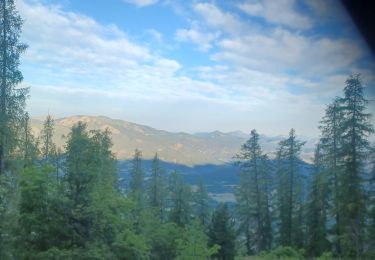
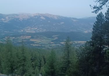
Départ dans la forêt. Le début suit le GR6 et grimpe bien dans la forêt.
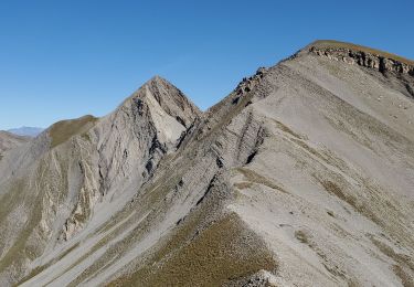
Après avoir quitté le GR6 le chemin est balisé en jaune et grimpe a flanc de montagne alternativement sous les arbres ou en traversant des pierriers. Les vues sur la vallée sont jolies.
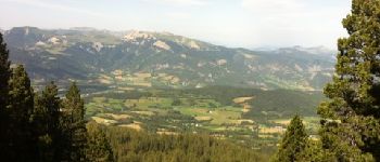
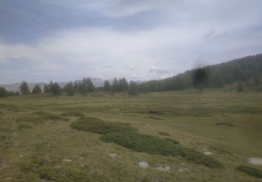
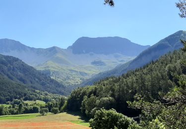
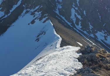
A partir du col bas, les paysages sont magnifiques: verdoyants avec des lacs et de jolies fleurs, le tout avec de grandes chaînes de montagne en arrière plan.
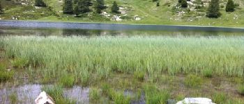
Après le lac noir, on continuera jusqu'au lac du milieu ombragé pour le picnic et la pêche.
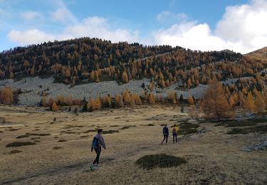
Pour le retour, après le passage du col, vous pouvez revenir par le même chemin ou suivre comme proposé la route forestière. (cette option est plus longue mais moins pentue...suivant l'état des jambes des participants)
Positioning
Comments
Trails nearby
![Trail Walking Seyne - Dormillouse, lac noir et tourbières - Photo](https://media.geolcdn.com/t/375/260/ext.jpg?maxdim=2&url=https%3A%2F%2Fservices.sitytrail.com%2FGeolivesWS%2FDownloadMedia.ashx%3FTrailID%3D327459%26Media%3Df2c4c15e-e615-4934-adf1-ad96c650c8e6.JPG)
![Walking Walking](https://static1.geolcdn.com/sitytour/trail-icons/101.png)
Walking
![](/images/other/stat-length.png)
![](https://static1.geolcdn.com/siteimages/upload/files/16400158638029165_repeat_loop_refresh_sync_direction_icon.png)
![Trail Walking Seyne - SEYNES LES ALPES . COL DE BERNARDES . PIC DE BERNARDES . PIC DE SAVERNES . COL BAS O N - Photo](https://media.geolcdn.com/t/375/260/b9753bd0-7cce-4d45-8b8c-6d083f8daf49.jpg&format=jpg&maxdim=2)
![Walking Walking](https://static1.geolcdn.com/sitytour/trail-icons/101.png)
Walking
![](/images/other/stat-length.png)
![](https://static1.geolcdn.com/siteimages/upload/files/16400158638029165_repeat_loop_refresh_sync_direction_icon.png)
![Trail Walking Seyne - Dormillouse lac noir lac du milieu lac de la cabane - Photo](https://media.geolcdn.com/t/375/260/74e953cb-f434-450d-b6b9-3b41df759f06.jpg&format=jpg&maxdim=2)
![Walking Walking](https://static1.geolcdn.com/sitytour/trail-icons/101.png)
Walking
![](/images/other/stat-length.png)
![](https://static1.geolcdn.com/siteimages/upload/files/16400158638029165_repeat_loop_refresh_sync_direction_icon.png)
![Trail Walking Seyne - SEYNES LES ALPES . Grand puy , montagne de la Blache , cabane du Mulet o l s - Photo](https://media.geolcdn.com/t/375/260/0a85776d-4fbe-44a9-8b16-bf4257f31cc2.jpg&format=jpg&maxdim=2)
![Walking Walking](https://static1.geolcdn.com/sitytour/trail-icons/101.png)
Walking
![](/images/other/stat-length.png)
![](https://static1.geolcdn.com/siteimages/upload/files/16400158638029165_repeat_loop_refresh_sync_direction_icon.png)
![Trail Walking Seyne - Dormillouse en boucle par le lac du Milieu - Photo](https://media.geolcdn.com/t/375/260/00b187e0-1b72-43f3-8118-43ef927b2ae4.jpg&format=jpg&maxdim=2)
![Walking Walking](https://static1.geolcdn.com/sitytour/trail-icons/101.png)
Walking
![](/images/other/stat-length.png)
![](https://static1.geolcdn.com/siteimages/upload/files/16400158638029165_repeat_loop_refresh_sync_direction_icon.png)
![Trail Walking Seyne - tour de tourtourel - Photo](https://media.geolcdn.com/t/375/260/ext.jpg?maxdim=2&url=https%3A%2F%2Fstatic1.geolcdn.com%2Fsiteimages%2Fupload%2Ffiles%2F1553511878bg_sport_marche.png)
![Walking Walking](https://static1.geolcdn.com/sitytour/trail-icons/101.png)
Walking
![](/images/other/stat-length.png)
![](https://static1.geolcdn.com/siteimages/upload/files/16400158638029165_repeat_loop_refresh_sync_direction_icon.png)
![Trail Walking Seyne - dos de chameau 1165m 12kms - Photo](https://media.geolcdn.com/t/375/260/20594f73-6d6a-4dc1-92d9-8c17fbfc97a8.jpg&format=jpg&maxdim=2)
![Walking Walking](https://static1.geolcdn.com/sitytour/trail-icons/101.png)
Walking
![](/images/other/stat-length.png)
![](https://static1.geolcdn.com/siteimages/upload/files/16400158638029165_repeat_loop_refresh_sync_direction_icon.png)
![Trail Walking Seyne - Seyne première bosse dos de chameau 9km 950m - Photo](https://media.geolcdn.com/t/375/260/5e0390cb-740a-4758-8977-417cce7cc0a2.jpg&format=jpg&maxdim=2)
![Walking Walking](https://static1.geolcdn.com/sitytour/trail-icons/101.png)
Walking
![](/images/other/stat-length.png)
![](https://static1.geolcdn.com/siteimages/upload/files/16400158638029165_repeat_loop_refresh_sync_direction_icon.png)
![Trail Walking Seyne - SEYNES. COL BAS . LES 3 LACS . O L S - Photo](https://media.geolcdn.com/t/375/260/e5d2149b-e657-4daa-9fdc-ea2fd440ca92.jpg&format=jpg&maxdim=2)
![Walking Walking](https://static1.geolcdn.com/sitytour/trail-icons/101.png)
Walking
![](/images/other/stat-length.png)
![](https://static1.geolcdn.com/siteimages/upload/files/16400158638029165_repeat_loop_refresh_sync_direction_icon.png)