Trail Walking Lagraulière - Lagrauliere - Photo
 houbart
houbart

User

© OpenStreetMap contributors
Length
Length
9.8 km
Max alt
Max alt
446 m
Uphill gradient
Uphill gradient
180 m
Km-Effort
Km-Effort  
12.2 km
Min alt
Min alt
351 m
Downhill gradient
Downhill gradient
180 m
Boucle
Boucle
Yes
Creation date :
2019-05-10 15:07:19.614
Updated on :
2019-05-10 15:12:12.007

(0 Reviews)

Walking
Walking
2h37
Difficulty : Medium

Scan this QR Code to open this trail in the SityTrail application

FREE GPS app for hiking

Logo SityTrail SityTrail

IGN / Geographical institutes

Download SityTrail from the App Store Download SityTrail from Google Play

Logo SityTrail SityTrail World

The world is yours!

Download SityTrail from the App Store Download SityTrail from Google Play Download SityTrail on Huawei AppGallery

About

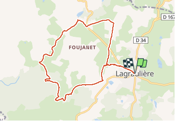
Trail Walking of 9.8 km to be discovered at New Aquitaine, Corrèze, Lagraulière. This trail is proposed by houbart.

Description

Eglise romane du XIIe, forêt de Blanchefort classée ZNIEFF. Pont de amoureux...

Elevation profile

Positioning

Country:
France
Region :
New Aquitaine
Department/Province :
Corrèze
Municipality :
Lagraulière
Location:
Unknown
Start:(UTM)
393366 ; 5023044 (31T) N.

Trails nearby

Trail Walking Lagraulière - Lagraulière - Le Picoulet - Photo
Walking
houbart

Walking

Easy
(1)
Lagraulière, New Aquitaine, Corrèze, France
4.8 km | 5.8 km-effort
1h 10min
Yes
Trail Walking Lagraulière - Lagauliere - Photo
Walking
dlaudain

Walking

Very easy
Lagraulière, New Aquitaine, Corrèze, France
4.8 km | 5.8 km-effort
1h 10min
Yes
Trail Walking Lagraulière - Lagraulière- Forêt de Blanchefort - Photo
Walking
houbart

Walking

Very easy
(1)
Lagraulière, New Aquitaine, Corrèze, France
8.9 km | 11.6 km-effort
2h 28min
Yes
Trail Walking Saint-Clément - Sur les Rails de Bussières - Saint Clément - Pays de Tulle - Photo
Walking
tracegps

Walking

Medium
Saint-Clément, New Aquitaine, Corrèze, France
9.9 km | 12.4 km-effort
2h 15min
Yes
Trail Walking Lagraulière - Le Moulin de Mazel - Lagraulière - Pays de Tulle - Photo
Walking
tracegps

Walking

Medium
(2)
Lagraulière, New Aquitaine, Corrèze, France
9.1 km | 11.6 km-effort
2h 30min
Yes
Trail Quad Lagraulière - sortie perpezac le noir - Photo
Quad
Joël Chalaud

Quad

Very easy
Lagraulière, New Aquitaine, Corrèze, France
44 km | 56 km-effort
4h 9min
Yes
Trail Walking Lagraulière - lagrauliere - Photo
Walking
personono

Walking

Very easy
Lagraulière, New Aquitaine, Corrèze, France
13.8 km | 17.1 km-effort
3h 21min
No
Trail Walking Chanteix - Chanteix- Du puy Maurians aux Zignalets - Photo
Walking
houbart

Walking

Easy
Chanteix, New Aquitaine, Corrèze, France
7.6 km | 9.8 km-effort
2h 14min
Yes
Trail Quad Lagraulière - Treignac - Photo
Quad
Joël Chalaud

Quad

Very easy
Lagraulière, New Aquitaine, Corrèze, France
108 km | 140 km-effort
10h 10min
Yes


Close
My subscriptions