![](/images/other/stat-length.png)
![Trail Equestrian Saint-Germain-de-Varreville - Randonnée Au Plain - Photo](https://media.geolcdn.com/t/1900/400/ext.pjpeg?maxdim=2&url=https%3A%2F%2Fstatic1.geolcdn.com%2Fsiteimages%2Fupload%2Ffiles%2F1524743154cheval.jpg)
Randonnée Au Plain
Bajac
User
![Length](/images/other/stat-length.png)
Length
26 km
![Max alt](https://static1.geolcdn.com/siteimages/upload/files/1508320355ic_sort_altitude_max_24dp.png)
Max alt
41 m
![Uphill gradient](https://static1.geolcdn.com/siteimages/upload/files/1508320355ic_sort_den_pos_24dp.png)
Uphill gradient
166 m
![Km-Effort](/images/other/stat-length.png)
Km-Effort
28 km
![Min alt](https://static1.geolcdn.com/siteimages/upload/files/1508320355ic_sort_altitude_min_24dp.png)
Min alt
2 m
![Downhill gradient](https://static1.geolcdn.com/siteimages/upload/files/1508320355ic_sort_den_neg_24dp.png)
Downhill gradient
167 m
![Boucle](https://static1.geolcdn.com/siteimages/upload/files/16400158638029165_repeat_loop_refresh_sync_direction_icon.png)
Boucle
Yes
Creation date :
2019-05-08 08:24:18.848
Updated on :
2019-05-08 09:00:23.28
![Equestrian](https://static1.geolcdn.com/sitytour/trail-icons/300.png)
--
Difficulty : Very easy
![Scan this QR Code to open this trail in the SityTrail application](https://capi.geolives.com/qq0zvz2zws4bq2lad0pu/sitytour/trails/2075141/qr.png?size=200)
FREE GPS app for hiking
About
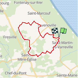
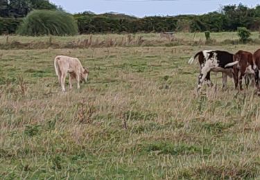
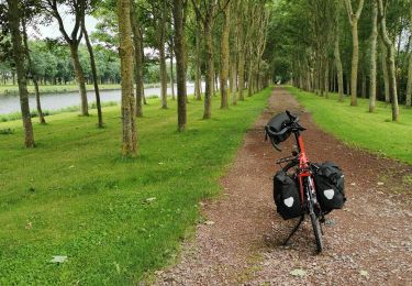
Trail Equestrian of 26 km to be discovered at Normandy, Manche, Saint-Germain-de-Varreville. This trail is proposed by Bajac.
Description
Boucle:
Départ de Saint Germain de Varreville, pique nique à la batterie d'Azerville, décroché par sainte Mère Eglise au choix...et retour à SGV
Positioning
Country:
France
Region :
Normandy
Department/Province :
Manche
Municipality :
Saint-Germain-de-Varreville
Location:
Unknown
Start:(Dec)
Start:(UTM)
627261 ; 5477559 (30U) N.
Comments
Trails nearby
![Trail Walking Saint-Martin-de-Varreville - Autour d'Utah-Beach - Saint Germain de Varreville - Photo](https://media.geolcdn.com/t/375/260/ext.jpg?maxdim=2&url=https%3A%2F%2Fservices.sitytrail.com%2FGeolivesWS%2FDownloadMedia.ashx%3FTrailID%3D111174%26Media%3D6616_2.jpg)
![Walking Walking](https://static1.geolcdn.com/sitytour/trail-icons/101.png)
Autour d'Utah-Beach - Saint Germain de Varreville
Walking
Medium
(1)
Saint-Martin-de-Varreville,
Normandy,
Manche,
France
![](/images/other/stat-length.png)
12.7 km | 13.4 km-effort
3h 0min
![](https://static1.geolcdn.com/siteimages/upload/files/16400158638029165_repeat_loop_refresh_sync_direction_icon.png)
Yes
![Trail Electric bike Sainte-Marie-du-Mont - Utah beach - Photo](https://media.geolcdn.com/t/375/260/ext.jpg?maxdim=2&url=https%3A%2F%2Fmedia.geolcdn.com%2Ff%2F923a514d-2b62-44c4-a21e-e787a976b928.jpg)
![Electric bike Electric bike](https://static1.geolcdn.com/sitytour/trail-icons/205.png)
Utah beach
Electric bike
Sainte-Marie-du-Mont,
Normandy,
Manche,
France
![](/images/other/stat-length.png)
6.1 km | 6.3 km-effort
38min
![](https://static1.geolcdn.com/siteimages/upload/files/16400158638029165_repeat_loop_refresh_sync_direction_icon.png)
Yes
![Trail Electric bike Sainte-Marie-du-Mont - Utah - Photo](https://media.geolcdn.com/t/375/260/ext.jpg?maxdim=2&url=https%3A%2F%2Fmedia.geolcdn.com%2Ff%2Fcb006d62-c160-4132-bedf-03ab63c9f6d8.jpg)
![Electric bike Electric bike](https://static1.geolcdn.com/sitytour/trail-icons/205.png)
Utah
Electric bike
Very easy
Sainte-Marie-du-Mont,
Normandy,
Manche,
France
![](/images/other/stat-length.png)
24 km | 26 km-effort
1h 39min
![](https://static1.geolcdn.com/siteimages/upload/files/16400158638029165_repeat_loop_refresh_sync_direction_icon.png)
Yes
![Trail Equestrian Saint-Germain-de-Varreville - st Germain - Azerville - Photo](https://media.geolcdn.com/t/375/260/ext.jpg?maxdim=2&url=https%3A%2F%2Fstatic1.geolcdn.com%2Fsiteimages%2Fupload%2Ffiles%2F1524743154cheval.jpg)
![Equestrian Equestrian](https://static1.geolcdn.com/sitytour/trail-icons/300.png)
st Germain - Azerville
Equestrian
Very easy
Saint-Germain-de-Varreville,
Normandy,
Manche,
France
![](/images/other/stat-length.png)
27 km | 29 km-effort
4h 0min
![](https://static1.geolcdn.com/siteimages/upload/files/16400158638029165_repeat_loop_refresh_sync_direction_icon.png)
Yes
![Trail Bicycle tourism Sainte-Marie-du-Mont - Vélomaritime_Cherbourg_Caen_#J3_20210707_Utah_Beach_-_Saint-Lô - Photo](https://media.geolcdn.com/t/375/260/ext.jpg?maxdim=2&url=https%3A%2F%2Fmedia.geolcdn.com%2Ff%2F2c67c0c6-e300-4f4d-871a-389c79fbf248.jpg)
![Bicycle tourism Bicycle tourism](https://static1.geolcdn.com/sitytour/trail-icons/204.png)
Vélomaritime_Cherbourg_Caen_#J3_20210707_Utah_Beach_-_Saint-Lô
Bicycle tourism
Very easy
Sainte-Marie-du-Mont,
Normandy,
Manche,
France
![](/images/other/stat-length.png)
62 km | 68 km-effort
Unknown
![](https://static1.geolcdn.com/siteimages/upload/files/16400158638029165_repeat_loop_refresh_sync_direction_icon.png)
No
![Trail Walking Saint-Martin-de-Varreville - Les Alentours d'Utah Beach - Photo](https://media.geolcdn.com/t/375/260/ext.jpg?maxdim=2&url=https%3A%2F%2Fstatic1.geolcdn.com%2Fsiteimages%2Fupload%2Ffiles%2F1553511878bg_sport_marche.png)
![Walking Walking](https://static1.geolcdn.com/sitytour/trail-icons/101.png)
Les Alentours d'Utah Beach
Walking
Easy
Saint-Martin-de-Varreville,
Normandy,
Manche,
France
![](/images/other/stat-length.png)
12.8 km | 13.6 km-effort
3h 30min
![](https://static1.geolcdn.com/siteimages/upload/files/16400158638029165_repeat_loop_refresh_sync_direction_icon.png)
Yes
![Trail Walking Saint-Martin-de-Varreville - Boucle Mémorial par St Martin Varreville - Photo](https://media.geolcdn.com/t/375/260/ext.jpg?maxdim=2&url=https%3A%2F%2Fstatic1.geolcdn.com%2Fsiteimages%2Fupload%2Ffiles%2F1553511878bg_sport_marche.png)
![Walking Walking](https://static1.geolcdn.com/sitytour/trail-icons/101.png)
Boucle Mémorial par St Martin Varreville
Walking
Very easy
Saint-Martin-de-Varreville,
Normandy,
Manche,
France
![](/images/other/stat-length.png)
9.1 km | 9.5 km-effort
2h 30min
![](https://static1.geolcdn.com/siteimages/upload/files/16400158638029165_repeat_loop_refresh_sync_direction_icon.png)
Yes
![Trail Walking Sainte-Marie-du-Mont - Tour du cotentin 2 - Photo](https://media.geolcdn.com/t/375/260/ext.jpg?maxdim=2&url=https%3A%2F%2Fstatic1.geolcdn.com%2Fsiteimages%2Fupload%2Ffiles%2F1553511878bg_sport_marche.png)
![Walking Walking](https://static1.geolcdn.com/sitytour/trail-icons/101.png)
Tour du cotentin 2
Walking
Sainte-Marie-du-Mont,
Normandy,
Manche,
France
![](/images/other/stat-length.png)
14.2 km | 14.8 km-effort
5h 27min
![](https://static1.geolcdn.com/siteimages/upload/files/16400158638029165_repeat_loop_refresh_sync_direction_icon.png)
No
![Trail On foot Turqueville - TURQUEVILLE - Photo](https://media.geolcdn.com/t/375/260/ext.jpg?maxdim=2&url=https%3A%2F%2Fstatic1.geolcdn.com%2Fsiteimages%2Fupload%2Ffiles%2F1545311037marcheuse_200dpi.jpg)
![On foot On foot](https://static1.geolcdn.com/sitytour/trail-icons/100.png)
TURQUEVILLE
On foot
Very easy
Turqueville,
Normandy,
Manche,
France
![](/images/other/stat-length.png)
9.9 km | 10.8 km-effort
Unknown
![](https://static1.geolcdn.com/siteimages/upload/files/16400158638029165_repeat_loop_refresh_sync_direction_icon.png)
Yes