![](/images/other/stat-length.png)
![Trail Walking Dornas - La ronde des hameaux - Photo](https://media.geolcdn.com/t/1900/400/8dece0da-4043-4530-9201-142dcd3029a9.jpg&format=pjpeg&maxdim=2)
La ronde des hameaux
bernadette revoux
User
![Length](/images/other/stat-length.png)
Length
18 km
![Max alt](https://static1.geolcdn.com/siteimages/upload/files/1508320355ic_sort_altitude_max_24dp.png)
Max alt
1131 m
![Uphill gradient](https://static1.geolcdn.com/siteimages/upload/files/1508320355ic_sort_den_pos_24dp.png)
Uphill gradient
853 m
![Km-Effort](/images/other/stat-length.png)
Km-Effort
29 km
![Min alt](https://static1.geolcdn.com/siteimages/upload/files/1508320355ic_sort_altitude_min_24dp.png)
Min alt
622 m
![Downhill gradient](https://static1.geolcdn.com/siteimages/upload/files/1508320355ic_sort_den_neg_24dp.png)
Downhill gradient
856 m
![Boucle](https://static1.geolcdn.com/siteimages/upload/files/16400158638029165_repeat_loop_refresh_sync_direction_icon.png)
Boucle
Yes
Creation date :
2019-05-04 05:58:12.505
Updated on :
2019-05-11 03:32:09.011
![Walking](https://static1.geolcdn.com/sitytour/trail-icons/101.png)
5h04
Difficulty : Difficult
![Scan this QR Code to open this trail in the SityTrail application](https://capi.geolives.com/qq0zvz2zws4bq2lad0pu/sitytour/trails/2071813/qr.png?size=200)
FREE GPS app for hiking
About
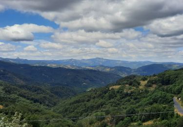
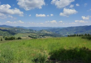
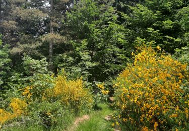
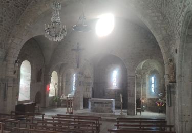
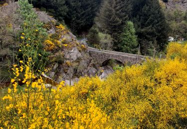
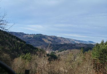
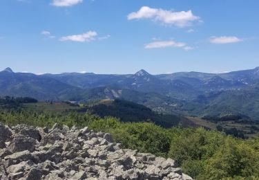
Trail Walking of 18 km to be discovered at Auvergne-Rhône-Alpes, Ardèche, Dornas. This trail is proposed by bernadette revoux.
Description
Val'Eyrieux Printemps de la rando
Départ de Dornas en fond de la vallée de la Dorne jusqu'aux Serres qui offrent de belles vues sur les communes de Dornas, saint-Andéol-de-Fourchades, et le Chambon.
Positioning
Country:
France
Region :
Auvergne-Rhône-Alpes
Department/Province :
Ardèche
Municipality :
Dornas
Location:
Unknown
Start:(Dec)
Start:(UTM)
606842 ; 4967553 (31T) N.
Comments
Trails nearby
![Trail Walking Marcols-les-Eaux - Marcols les Eaux 18km - Photo](https://media.geolcdn.com/t/375/260/d0a8230b-cb3c-4508-b2c3-0cef161569ba.jpg&format=jpg&maxdim=2)
![Walking Walking](https://static1.geolcdn.com/sitytour/trail-icons/101.png)
Marcols les Eaux 18km
Walking
Very difficult
Marcols-les-Eaux,
Auvergne-Rhône-Alpes,
Ardèche,
France
![](/images/other/stat-length.png)
18.2 km | 29 km-effort
6h 29min
![](https://static1.geolcdn.com/siteimages/upload/files/16400158638029165_repeat_loop_refresh_sync_direction_icon.png)
Yes
![Trail Walking Mariac - Vallée des Tuiliers 14km - Photo](https://media.geolcdn.com/t/375/260/7baf5c42-0be7-4650-9019-a65fd62ddc79.jpg&format=jpg&maxdim=2)
![Walking Walking](https://static1.geolcdn.com/sitytour/trail-icons/101.png)
Vallée des Tuiliers 14km
Walking
Medium
Mariac,
Auvergne-Rhône-Alpes,
Ardèche,
France
![](/images/other/stat-length.png)
15.6 km | 24 km-effort
6h 16min
![](https://static1.geolcdn.com/siteimages/upload/files/16400158638029165_repeat_loop_refresh_sync_direction_icon.png)
Yes
![Trail Walking Mariac - Mariac Sentier des Tuiliers 14km - Photo](https://media.geolcdn.com/t/375/260/df355878-8825-4676-b8f8-62d9caa79c91.jpg&format=jpg&maxdim=2)
![Walking Walking](https://static1.geolcdn.com/sitytour/trail-icons/101.png)
Mariac Sentier des Tuiliers 14km
Walking
Difficult
Mariac,
Auvergne-Rhône-Alpes,
Ardèche,
France
![](/images/other/stat-length.png)
14.8 km | 23 km-effort
5h 48min
![](https://static1.geolcdn.com/siteimages/upload/files/16400158638029165_repeat_loop_refresh_sync_direction_icon.png)
Yes
![Trail Walking Mariac - Mariac-Chadenac - Photo](https://media.geolcdn.com/t/375/260/55f1b943-0565-41d9-b8b1-5e22b8cb78de.jpg&format=jpg&maxdim=2)
![Walking Walking](https://static1.geolcdn.com/sitytour/trail-icons/101.png)
Mariac-Chadenac
Walking
Difficult
Mariac,
Auvergne-Rhône-Alpes,
Ardèche,
France
![](/images/other/stat-length.png)
11.9 km | 18 km-effort
2h 22min
![](https://static1.geolcdn.com/siteimages/upload/files/16400158638029165_repeat_loop_refresh_sync_direction_icon.png)
Yes
![Trail Walking Dornas - la Ronde des hameaux - Photo](https://media.geolcdn.com/t/375/260/7c22101a-d7e9-4c9f-82c5-8e210f023578.jpg&format=jpg&maxdim=2)
![Walking Walking](https://static1.geolcdn.com/sitytour/trail-icons/101.png)
la Ronde des hameaux
Walking
Difficult
Dornas,
Auvergne-Rhône-Alpes,
Ardèche,
France
![](/images/other/stat-length.png)
23 km | 35 km-effort
5h 35min
![](https://static1.geolcdn.com/siteimages/upload/files/16400158638029165_repeat_loop_refresh_sync_direction_icon.png)
Yes
![Trail Electric bike Accons - boucle Dolce via - Photo](https://media.geolcdn.com/t/375/260/8050fcc3-c78f-4267-bc15-cf72eee30110.jpg&format=jpg&maxdim=2)
![Electric bike Electric bike](https://static1.geolcdn.com/sitytour/trail-icons/205.png)
boucle Dolce via
Electric bike
Medium
Accons,
Auvergne-Rhône-Alpes,
Ardèche,
France
![](/images/other/stat-length.png)
73 km | 95 km-effort
4h 29min
![](https://static1.geolcdn.com/siteimages/upload/files/16400158638029165_repeat_loop_refresh_sync_direction_icon.png)
Yes
![Trail Walking Mézilhac - Sardiges Lachamps 14km - Photo](https://media.geolcdn.com/t/375/260/ext.jpg?maxdim=2&url=https%3A%2F%2Fstatic1.geolcdn.com%2Fsiteimages%2Fupload%2Ffiles%2F1553511878bg_sport_marche.png)
![Walking Walking](https://static1.geolcdn.com/sitytour/trail-icons/101.png)
Sardiges Lachamps 14km
Walking
Medium
Mézilhac,
Auvergne-Rhône-Alpes,
Ardèche,
France
![](/images/other/stat-length.png)
14.5 km | 23 km-effort
5h 0min
![](https://static1.geolcdn.com/siteimages/upload/files/16400158638029165_repeat_loop_refresh_sync_direction_icon.png)
Yes
![Trail Walking Marcols-les-Eaux - Marc il - Photo](https://media.geolcdn.com/t/375/260/ext.jpg?maxdim=2&url=https%3A%2F%2Fstatic1.geolcdn.com%2Fsiteimages%2Fupload%2Ffiles%2F1553511878bg_sport_marche.png)
![Walking Walking](https://static1.geolcdn.com/sitytour/trail-icons/101.png)
Marc il
Walking
Marcols-les-Eaux,
Auvergne-Rhône-Alpes,
Ardèche,
France
![](/images/other/stat-length.png)
15.5 km | 23 km-effort
5h 38min
![](https://static1.geolcdn.com/siteimages/upload/files/16400158638029165_repeat_loop_refresh_sync_direction_icon.png)
Yes
![Trail Walking Mariac - suc de Jaffre - Photo](https://media.geolcdn.com/t/375/260/52399ba1-0dfb-45e6-a8d4-31f20f9f1d21.jpg&format=jpg&maxdim=2)
![Walking Walking](https://static1.geolcdn.com/sitytour/trail-icons/101.png)
suc de Jaffre
Walking
Medium
Mariac,
Auvergne-Rhône-Alpes,
Ardèche,
France
![](/images/other/stat-length.png)
13.6 km | 21 km-effort
5h 28min
![](https://static1.geolcdn.com/siteimages/upload/files/16400158638029165_repeat_loop_refresh_sync_direction_icon.png)
Yes