Trail Walking Orbey - Beubois (02/05/2029/ - Photo

Beubois (02/05/2029/

© OpenStreetMap contributors
Length
Length
6.1 km
Max alt
Max alt
1062 m
Uphill gradient
Uphill gradient
295 m
Km-Effort
Km-Effort  
10 km
Min alt
Min alt
796 m
Downhill gradient
Downhill gradient
281 m
Boucle
Boucle
Yes
Creation date :
2019-05-02 07:33:14.808
Updated on :
2019-05-20 12:52:07.97

(0 Reviews)

Walking
Walking
2h27
Difficulty : Easy

Scan this QR Code to open this trail in the SityTrail application

FREE GPS app for hiking

Logo SityTrail SityTrail

IGN / Geographical institutes

Download SityTrail from the App Store Download SityTrail from Google Play

Logo SityTrail SityTrail World

The world is yours!

Download SityTrail from the App Store Download SityTrail from Google Play Download SityTrail on Huawei AppGallery

About

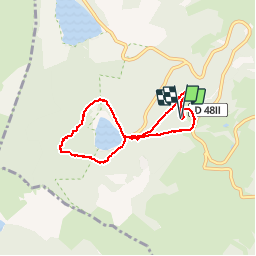
Trail Walking of 6.1 km to be discovered at Grand Est, Haut-Rhin, Orbey. This trail is proposed by Richard68500.

Description


Le Domaine du Beubois est situé sur les hauteurs d’Orbey à 800 mètres d’altitude, sous le lac Noir, dans la vallée de Kaysersberg en Alsace. Ce cadre bucolique est parfait pour accueillir les familles, les randonneurs, les sportifs, les touristes et même les entreprises…

Elevation profile

Photos

Positioning

Country:
France
Region :
Grand Est
Department/Province :
Haut-Rhin
Municipality :
Orbey
Location:
Unknown
Start:(UTM)
359301 ; 5330806 (32U) N.

Trails nearby

Trail Horseback riding Orbey - 2020-06-28 WE Orbey Petit Hohnack Glasborn - Photo
Horseback riding
GUIDE
holtzv

Horseback riding

Difficult
(1)
Orbey, Grand Est, Haut-Rhin, France
22 km | 31 km-effort
4h 5min
Yes
Trail Horseback riding Orbey - 2020-06-27 WE Orbey Noir Gazon Vert Forlet - Photo
Horseback riding
GUIDE
holtzv

Horseback riding

Medium
(1)
Orbey, Grand Est, Haut-Rhin, France
21 km | 30 km-effort
3h 59min
Yes
Trail Other activity Soultzeren - Totom 4 lacs - Photo
Other activity
dinozore

Other activity

Medium
(1)
Soultzeren, Grand Est, Haut-Rhin, France
15.6 km | 26 km-effort
4h 37min
Yes
Trail Walking Orbey - Le Tour du Lac Blanc par le Rocher Hans et le sentier de crête - Photo
Walking
tracegps

Walking

Difficult
(3)
Orbey, Grand Est, Haut-Rhin, France
4.4 km | 7.7 km-effort
2h 30min
Yes
Trail Walking Le Bonhomme - Tête des faux . - Photo
Walking
heurtinpatrick

Walking

Medium
(1)
Le Bonhomme, Grand Est, Haut-Rhin, France
11.9 km | 16.6 km-effort
3h 46min
Yes
Trail Walking Soultzeren - Tanet-Gazon du faing par lac vert et retour sommet du Tanet - Photo
Walking
ride-in-Elsass

Walking

Medium
(1)
Soultzeren, Grand Est, Haut-Rhin, France
10 km | 15.6 km-effort
4h 24min
Yes
Trail Walking Lapoutroie - 2012-06-16 Marche aux Alisiers Orbey - Photo
Walking
GUIDE
holtzv

Walking

Easy
(2)
Lapoutroie, Grand Est, Haut-Rhin, France
11.1 km | 16.6 km-effort
2h 49min
Yes
Trail Mountain bike Orbey - Lac Blanc  - Têtes des Faux - Photo
Mountain bike
tracegps

Mountain bike

Medium
(1)
Orbey, Grand Est, Haut-Rhin, France
15.3 km | 21 km-effort
1h 0min
Yes
Trail Horseback riding Gunsbach - Le petit Hohnack - verkort (23) - Photo
Horseback riding
eddyvermeulen1

Horseback riding

Easy
(1)
Gunsbach, Grand Est, Haut-Rhin, France
13.1 km | 18.4 km-effort
2h 25min
Yes


Close
My subscriptions