![](/images/other/stat-length.png)
![Trail Walking Montignac-Charente - La rando de Puyssanganou entre Montignac et saint Amand de Boixe - Photo](https://media.geolcdn.com/t/1900/400/0f0e26a1-a6e1-462a-84d4-61dad692ae20.jpg&format=pjpeg&maxdim=2)
La rando de Puyssanganou entre Montignac et saint Amand de Boixe
alainjoseph6
User
![Length](/images/other/stat-length.png)
Length
10.6 km
![Max alt](https://static1.geolcdn.com/siteimages/upload/files/1508320355ic_sort_altitude_max_24dp.png)
Max alt
114 m
![Uphill gradient](https://static1.geolcdn.com/siteimages/upload/files/1508320355ic_sort_den_pos_24dp.png)
Uphill gradient
153 m
![Km-Effort](/images/other/stat-length.png)
Km-Effort
12.7 km
![Min alt](https://static1.geolcdn.com/siteimages/upload/files/1508320355ic_sort_altitude_min_24dp.png)
Min alt
49 m
![Downhill gradient](https://static1.geolcdn.com/siteimages/upload/files/1508320355ic_sort_den_neg_24dp.png)
Downhill gradient
157 m
![Boucle](https://static1.geolcdn.com/siteimages/upload/files/16400158638029165_repeat_loop_refresh_sync_direction_icon.png)
Boucle
Yes
Creation date :
2019-05-02 12:15:28.817
Updated on :
2019-05-02 15:34:44.354
![Walking](https://static1.geolcdn.com/sitytour/trail-icons/101.png)
3h18
Difficulty : Medium
![Scan this QR Code to open this trail in the SityTrail application](https://capi.geolives.com/qq0zvz2zws4bq2lad0pu/sitytour/trails/2070882/qr.png?size=200)
FREE GPS app for hiking
About
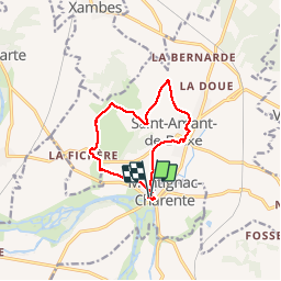
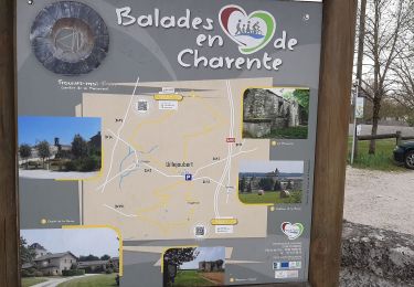
Trail Walking of 10.6 km to be discovered at New Aquitaine, Charente, Montignac-Charente. This trail is proposed by alainjoseph6.
Description
C'est une agréable rando entre la vallée de la Charente et Saint Amand de Boixe en parcourant de magnifiques chemins avec de nombreux points de vue.
Positioning
Country:
France
Region :
New Aquitaine
Department/Province :
Charente
Municipality :
Montignac-Charente
Location:
Unknown
Start:(Dec)
Start:(UTM)
276366 ; 5074147 (31T) N.
Comments
Trails nearby
![Trail Walking Villejoubert - Villejoubert et le château de la Barre - Photo](https://media.geolcdn.com/t/375/260/907ad314-aab5-49d2-9367-f56fc4587c7a.jpg&format=jpg&maxdim=2)
![Walking Walking](https://static1.geolcdn.com/sitytour/trail-icons/101.png)
Villejoubert et le château de la Barre
Walking
Medium
Villejoubert,
New Aquitaine,
Charente,
France
![](/images/other/stat-length.png)
7.4 km | 8.6 km-effort
2h 17min
![](https://static1.geolcdn.com/siteimages/upload/files/16400158638029165_repeat_loop_refresh_sync_direction_icon.png)
Yes
![Trail Walking Vouharte - Les hauts de VOUHARTE Charente - Photo](https://media.geolcdn.com/t/375/260/3c61a0db-af5d-42e2-9149-a0b6d1b08d1f.jpg&format=jpg&maxdim=2)
![Walking Walking](https://static1.geolcdn.com/sitytour/trail-icons/101.png)
Les hauts de VOUHARTE Charente
Walking
Medium
Vouharte,
New Aquitaine,
Charente,
France
![](/images/other/stat-length.png)
7.6 km | 9.1 km-effort
2h 56min
![](https://static1.geolcdn.com/siteimages/upload/files/16400158638029165_repeat_loop_refresh_sync_direction_icon.png)
Yes
![Trail Walking Villejoubert - De Villejoubert à la Macarine - Photo](https://media.geolcdn.com/t/375/260/492a0f69-240e-440b-ad62-3e34775d9d25.jpg&format=jpg&maxdim=2)
![Walking Walking](https://static1.geolcdn.com/sitytour/trail-icons/101.png)
De Villejoubert à la Macarine
Walking
Easy
Villejoubert,
New Aquitaine,
Charente,
France
![](/images/other/stat-length.png)
4.9 km | 5.7 km-effort
1h 51min
![](https://static1.geolcdn.com/siteimages/upload/files/16400158638029165_repeat_loop_refresh_sync_direction_icon.png)
Yes
![Trail Walking Villejoubert - La randonnée de La Macarine - Photo](https://media.geolcdn.com/t/375/260/db059127-d362-4189-afda-718da456fa14.jpg&format=jpg&maxdim=2)
![Walking Walking](https://static1.geolcdn.com/sitytour/trail-icons/101.png)
La randonnée de La Macarine
Walking
Easy
(1)
Villejoubert,
New Aquitaine,
Charente,
France
![](/images/other/stat-length.png)
10.8 km | 12.2 km-effort
3h 12min
![](https://static1.geolcdn.com/siteimages/upload/files/16400158638029165_repeat_loop_refresh_sync_direction_icon.png)
Yes
![Trail Running Marsac - 2023-10-15 Marsac (Charente) - Photo](https://media.geolcdn.com/t/375/260/ext.jpg?maxdim=2&url=https%3A%2F%2Fstatic1.geolcdn.com%2Fsiteimages%2Fupload%2Ffiles%2F1524743154running.jpg)
![Running Running](https://static1.geolcdn.com/sitytour/trail-icons/103.png)
2023-10-15 Marsac (Charente)
Running
Easy
Marsac,
New Aquitaine,
Charente,
France
![](/images/other/stat-length.png)
10 km | 12.4 km-effort
1h 4min
![](https://static1.geolcdn.com/siteimages/upload/files/16400158638029165_repeat_loop_refresh_sync_direction_icon.png)
Yes
![Trail Walking Marsac - marsac - Photo](https://media.geolcdn.com/t/375/260/ext.jpg?maxdim=2&url=https%3A%2F%2Fstatic1.geolcdn.com%2Fsiteimages%2Fupload%2Ffiles%2F1553511878bg_sport_marche.png)
![Walking Walking](https://static1.geolcdn.com/sitytour/trail-icons/101.png)
marsac
Walking
Very easy
Marsac,
New Aquitaine,
Charente,
France
![](/images/other/stat-length.png)
9.4 km | 11.5 km-effort
2h 28min
![](https://static1.geolcdn.com/siteimages/upload/files/16400158638029165_repeat_loop_refresh_sync_direction_icon.png)
No
![Trail Walking Marsac - Marsac180220 - Photo](https://media.geolcdn.com/t/375/260/ext.jpg?maxdim=2&url=https%3A%2F%2Fstatic1.geolcdn.com%2Fsiteimages%2Fupload%2Ffiles%2F1553511878bg_sport_marche.png)
![Walking Walking](https://static1.geolcdn.com/sitytour/trail-icons/101.png)
Marsac180220
Walking
Very easy
Marsac,
New Aquitaine,
Charente,
France
![](/images/other/stat-length.png)
11.8 km | 15.5 km-effort
3h 7min
![](https://static1.geolcdn.com/siteimages/upload/files/16400158638029165_repeat_loop_refresh_sync_direction_icon.png)
Yes
![Trail Walking Vars - vars190120 - Photo](https://media.geolcdn.com/t/375/260/ext.jpg?maxdim=2&url=https%3A%2F%2Fstatic1.geolcdn.com%2Fsiteimages%2Fupload%2Ffiles%2F1553511878bg_sport_marche.png)
![Walking Walking](https://static1.geolcdn.com/sitytour/trail-icons/101.png)
vars190120
Walking
Very easy
Vars,
New Aquitaine,
Charente,
France
![](/images/other/stat-length.png)
10.8 km | 13 km-effort
2h 44min
![](https://static1.geolcdn.com/siteimages/upload/files/16400158638029165_repeat_loop_refresh_sync_direction_icon.png)
Yes
![Trail Walking Vouharte - vouharte1012 - Photo](https://media.geolcdn.com/t/375/260/ext.jpg?maxdim=2&url=https%3A%2F%2Fstatic1.geolcdn.com%2Fsiteimages%2Fupload%2Ffiles%2F1553511878bg_sport_marche.png)
![Walking Walking](https://static1.geolcdn.com/sitytour/trail-icons/101.png)
vouharte1012
Walking
Very easy
Vouharte,
New Aquitaine,
Charente,
France
![](/images/other/stat-length.png)
11.3 km | 13.5 km-effort
2h 44min
![](https://static1.geolcdn.com/siteimages/upload/files/16400158638029165_repeat_loop_refresh_sync_direction_icon.png)
Yes