Trail Walking Verdaches - 20190430_Sommet du Blayeul Via Verdaches - Photo

20190430_Sommet du Blayeul Via Verdaches

© OpenStreetMap contributors
Length
Length
13.4 km
Max alt
Max alt
2182 m
Uphill gradient
Uphill gradient
1136 m
Km-Effort
Km-Effort  
28 km
Min alt
Min alt
1118 m
Downhill gradient
Downhill gradient
1136 m
Boucle
Boucle
Yes
Creation date :
2019-04-30 07:21:02.373
Updated on :
2019-06-06 17:02:35.506

(0 Reviews)

Walking
Walking
6h11
Difficulty : Difficult

Scan this QR Code to open this trail in the SityTrail application

FREE GPS app for hiking

Logo SityTrail SityTrail

IGN / Geographical institutes

Download SityTrail from the App Store Download SityTrail from Google Play

Logo SityTrail SityTrail World

The world is yours!

Download SityTrail from the App Store Download SityTrail from Google Play Download SityTrail on Huawei AppGallery

About

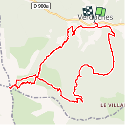
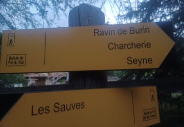
Trail Walking of 13.4 km to be discovered at Provence-Alpes-Côte d'Azur, Alpes-de-Haute-Provence, Verdaches. This trail is proposed by PapouBertrand.

Description

Rando CSA Gap, au départ de Verdaches, de 6 heures, 13 KM et 1100 mètres de dénivelé avec de beaux panoramas.

Elevation profile

Photos

Positioning

Country:
France
Region :
Provence-Alpes-Côte d'Azur
Department/Province :
Alpes-de-Haute-Provence
Municipality :
Verdaches
Location:
Unknown
Start:(UTM)
287776 ; 4904547 (32T) N.

Trails nearby

Trail Walking Le Vernet - grisonniere montagne ubac belliers960m 15kms  - Photo
Walking
GUIDE
Danielba

Walking

Difficult
Le Vernet, Provence-Alpes-Côte d'Azur, Alpes-de-Haute-Provence, France
14.2 km | 26 km-effort
7h 19min
Yes
Trail Walking Beaujeu - LA JAVIE.  COL DE BOUILLARD . CRETES DU BLAYEUL  LED AJUSTATS . COL DE BOUILLARD N   - Photo
Walking
RobinMicheline

Walking

Difficult
Beaujeu, Provence-Alpes-Côte d'Azur, Alpes-de-Haute-Provence, France
12.7 km | 24 km-effort
4h 49min
Yes
Trail Walking Le Vernet - LE VERNET . COL DU MAL D HIVER . COL DU LABOURET . O L M  - Photo
Walking
RobinMicheline

Walking

Medium
(1)
Le Vernet, Provence-Alpes-Côte d'Azur, Alpes-de-Haute-Provence, France
13 km | 17.4 km-effort
3h 17min
Yes
Trail On foot Le Vernet - Boucle route des Béliers-Le col de Mariaud-Barre des Béliers-Col de la Grisonnière-Cabane du berger - Photo
On foot
Monique14

On foot

Easy
Le Vernet, Provence-Alpes-Côte d'Azur, Alpes-de-Haute-Provence, France
8.4 km | 16.3 km-effort
3h 42min
Yes
Trail On foot Le Vernet - Boucle Le Vernet-Le Haut Vernet-Le Vernet-Villevielle-Le Vernet - Photo
On foot
Monique14

On foot

Easy
Le Vernet, Provence-Alpes-Côte d'Azur, Alpes-de-Haute-Provence, France
5.8 km | 8.4 km-effort
1h 54min
Yes
Trail Walking Barles - BARLES .TOUR DES CLUES DE VERDACHES O L  - Photo
Walking
RobinMicheline

Walking

Medium
Barles, Provence-Alpes-Côte d'Azur, Alpes-de-Haute-Provence, France
9 km | 14.3 km-effort
2h 59min
Yes
Trail Walking Le Vernet - Sommet de Grisonnière via le Vernet - Photo
Walking
PapouBertrand

Walking

Very difficult
Le Vernet, Provence-Alpes-Côte d'Azur, Alpes-de-Haute-Provence, France
10.1 km | 20 km-effort
5h 8min
Yes
Trail On foot Verdaches - VERDACHES  . BALADE DU PRE DES BOIS O L M S - Photo
On foot
RobinMicheline

On foot

Easy
Verdaches, Provence-Alpes-Côte d'Azur, Alpes-de-Haute-Provence, France
13.4 km | 19.2 km-effort
4h 21min
Yes
Trail Walking Barles - BARLES  . LE LAUSS . L ARDOISIERE . O - Photo
Walking
RobinMicheline

Walking

Easy
Barles, Provence-Alpes-Côte d'Azur, Alpes-de-Haute-Provence, France
6.3 km | 10.4 km-effort
1h 41min
Yes


Close
My subscriptions