![](/images/other/stat-length.png)
![Trail Walking Soajo - Wikiloc - Soajo - Cunhas - Cabeço da Trapela - Adrão (PNPG/ Parque Nac... - Photo](https://media.geolcdn.com/t/1900/400/f05feac8-d686-4eda-b62e-067b2b53db42.jpg&format=pjpeg&maxdim=2)
Wikiloc - Soajo - Cunhas - Cabeço da Trapela - Adrão (PNPG/ Parque Nac...
michelek
User
![Length](/images/other/stat-length.png)
![Max alt](https://static1.geolcdn.com/siteimages/upload/files/1508320355ic_sort_altitude_max_24dp.png)
![Uphill gradient](https://static1.geolcdn.com/siteimages/upload/files/1508320355ic_sort_den_pos_24dp.png)
![Km-Effort](/images/other/stat-length.png)
![Min alt](https://static1.geolcdn.com/siteimages/upload/files/1508320355ic_sort_altitude_min_24dp.png)
![Downhill gradient](https://static1.geolcdn.com/siteimages/upload/files/1508320355ic_sort_den_neg_24dp.png)
![Boucle](https://static1.geolcdn.com/siteimages/upload/files/16400158638029165_repeat_loop_refresh_sync_direction_icon.png)
![Walking](https://static1.geolcdn.com/sitytour/trail-icons/101.png)
5h50
Difficulty : Very difficult
![Scan this QR Code to open this trail in the SityTrail application](https://capi.geolives.com/qq0zvz2zws4bq2lad0pu/sitytour/trails/2068527/qr.png?size=200)
FREE GPS app for hiking
About
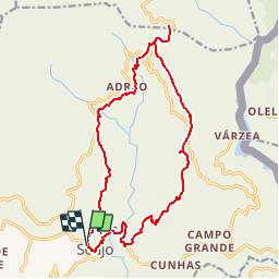
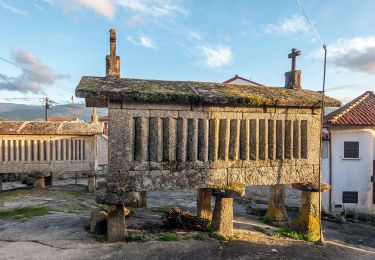
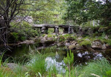
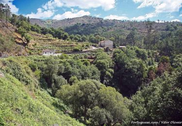
Trail Walking of 18.6 km to be discovered at North, Viana do Castelo, Soajo. This trail is proposed by michelek.
Description
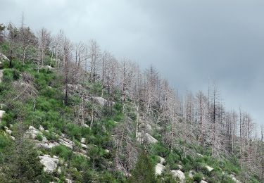
Au départ de Soajo, montée vers Adrão puis poursuivre la montée. Via la route vers Gaveira atteindre un point de vue sur toute la vallée et vers Peneda.
Retour par l'autre versant de la vallée du Rio Adrāo et retour à Soajo.
La montée jusqu'à la route vers Gaveira est bien balisée en jaune-rouge.
Plus de balisage ensuite.
Positioning
Comments
Trails nearby
![Trail On foot São Jorge e Ermelo - Ecovia do Ermelo - Photo](https://media.geolcdn.com/t/375/260/b03fc189-bb7f-4693-923a-e99f2c946cbf.jpeg&format=jpg&maxdim=2)
![On foot On foot](https://static1.geolcdn.com/sitytour/trail-icons/100.png)
On foot
![](/images/other/stat-length.png)
![](https://static1.geolcdn.com/siteimages/upload/files/16400158638029165_repeat_loop_refresh_sync_direction_icon.png)
![Trail On foot Soajo - Romeiros da Peneda – Rota de Soajo (Ligação ao Mezio) - Photo](https://media.geolcdn.com/t/375/260/dd92e101-f588-4d83-818c-c174924529a5.jpeg&format=jpg&maxdim=2)
![On foot On foot](https://static1.geolcdn.com/sitytour/trail-icons/100.png)
On foot
![](/images/other/stat-length.png)
![](https://static1.geolcdn.com/siteimages/upload/files/16400158638029165_repeat_loop_refresh_sync_direction_icon.png)
![Trail On foot Soajo - Caminhos do Pão e Caminhos da Fé (Percurso Longo) - Photo](https://media.geolcdn.com/t/375/260/cf81bae1-2829-458c-bd3c-13bf2cad7f93.jpeg&format=jpg&maxdim=2)
![On foot On foot](https://static1.geolcdn.com/sitytour/trail-icons/100.png)
On foot
![](/images/other/stat-length.png)
![](https://static1.geolcdn.com/siteimages/upload/files/16400158638029165_repeat_loop_refresh_sync_direction_icon.png)
![Trail On foot - Trilho dos Moinhos de Parada - Photo](https://media.geolcdn.com/t/375/260/6eaa782e-40f4-4a22-a3ec-96e43151c6f3.jpeg&format=jpg&maxdim=2)
![On foot On foot](https://static1.geolcdn.com/sitytour/trail-icons/100.png)
On foot
![](/images/other/stat-length.png)
![](https://static1.geolcdn.com/siteimages/upload/files/16400158638029165_repeat_loop_refresh_sync_direction_icon.png)
![Trail On foot Britelo - Trilho do Megalitismo de Britelo - Photo](https://media.geolcdn.com/t/375/260/e2206b2e-b34e-4da8-812b-f716f235ec18.jpeg&format=jpg&maxdim=2)
![On foot On foot](https://static1.geolcdn.com/sitytour/trail-icons/100.png)
On foot
![](/images/other/stat-length.png)
![](https://static1.geolcdn.com/siteimages/upload/files/16400158638029165_repeat_loop_refresh_sync_direction_icon.png)
![Trail On foot Soajo - Romeiros da Peneda – Rota de Soajo - Photo](https://media.geolcdn.com/t/375/260/270c7521-c16a-423e-8a0f-e1c8e6366d43.jpeg&format=jpg&maxdim=2)
![On foot On foot](https://static1.geolcdn.com/sitytour/trail-icons/100.png)
On foot
![](/images/other/stat-length.png)
![](https://static1.geolcdn.com/siteimages/upload/files/16400158638029165_repeat_loop_refresh_sync_direction_icon.png)
![Trail On foot Soajo - Trilho da Ribeira de Vilela - Photo](https://media.geolcdn.com/t/375/260/00592fd8-2e16-415d-af9e-21182cfbc764.jpeg&format=jpg&maxdim=2)
![On foot On foot](https://static1.geolcdn.com/sitytour/trail-icons/100.png)
On foot
![](/images/other/stat-length.png)
![](https://static1.geolcdn.com/siteimages/upload/files/16400158638029165_repeat_loop_refresh_sync_direction_icon.png)
![Trail On foot Soajo - Trilho do Ramil - Photo](https://media.geolcdn.com/t/375/260/a0d1e248-7bed-4254-9c93-5ea466c2e602.jpeg&format=jpg&maxdim=2)
![On foot On foot](https://static1.geolcdn.com/sitytour/trail-icons/100.png)
On foot
![](/images/other/stat-length.png)
![](https://static1.geolcdn.com/siteimages/upload/files/16400158638029165_repeat_loop_refresh_sync_direction_icon.png)
![Trail Walking Soajo - Wikiloc - Soajo - Paradela - Porco - Adrão (PNPG/ Parque Nacional da P... - Photo](https://media.geolcdn.com/t/375/260/ext.jpg?maxdim=2&url=https%3A%2F%2Fstatic1.geolcdn.com%2Fsiteimages%2Fupload%2Ffiles%2F1553511878bg_sport_marche.png)
![Walking Walking](https://static1.geolcdn.com/sitytour/trail-icons/101.png)
Walking
![](/images/other/stat-length.png)
![](https://static1.geolcdn.com/siteimages/upload/files/16400158638029165_repeat_loop_refresh_sync_direction_icon.png)