![](/images/other/stat-length.png)
![Trail Walking Valdeblore - Mont Viroulet et petit Cayres.Départ Bolline b139 - Photo](https://media.geolcdn.com/t/1900/400/ext.pjpeg?maxdim=2&url=https%3A%2F%2Fmedia.geolcdn.com%2Ff%2F9c3c5574-e533-4881-96ee-06235bc21d6e.jpg)
Mont Viroulet et petit Cayres.Départ Bolline b139
GrouGary
User
![Length](/images/other/stat-length.png)
Length
14.8 km
![Max alt](https://static1.geolcdn.com/siteimages/upload/files/1508320355ic_sort_altitude_max_24dp.png)
Max alt
1908 m
![Uphill gradient](https://static1.geolcdn.com/siteimages/upload/files/1508320355ic_sort_den_pos_24dp.png)
Uphill gradient
1000 m
![Km-Effort](/images/other/stat-length.png)
Km-Effort
28 km
![Min alt](https://static1.geolcdn.com/siteimages/upload/files/1508320355ic_sort_altitude_min_24dp.png)
Min alt
1017 m
![Downhill gradient](https://static1.geolcdn.com/siteimages/upload/files/1508320355ic_sort_den_neg_24dp.png)
Downhill gradient
999 m
![Boucle](https://static1.geolcdn.com/siteimages/upload/files/16400158638029165_repeat_loop_refresh_sync_direction_icon.png)
Boucle
Yes
Creation date :
2019-04-20 05:53:46.361
Updated on :
2019-06-15 16:26:07.833
![Walking](https://static1.geolcdn.com/sitytour/trail-icons/101.png)
6h30
Difficulty : Medium
![Scan this QR Code to open this trail in the SityTrail application](https://capi.geolives.com/qq0zvz2zws4bq2lad0pu/sitytour/trails/2064477/qr.png?size=200)
FREE GPS app for hiking
About
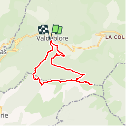
Trail Walking of 14.8 km to be discovered at Provence-Alpes-Côte d'Azur, Maritime Alps, Valdeblore. This trail is proposed by GrouGary.
Description
circuit départ église St Jacques de la Bolline,montée bois noir de Serena puis au dessus de Marie dans la foret de Lauzetta, plan d'Arous puis les pentes de Viroulet. Retour par col de la Madeleine et descente au collet du Puy. 1100
Positioning
Country:
France
Region :
Provence-Alpes-Côte d'Azur
Department/Province :
Maritime Alps
Municipality :
Valdeblore
Location:
Unknown
Start:(Dec)
Start:(UTM)
353502 ; 4881214 (32T) N.
Comments
Trails nearby
![Trail Walking Valdeblore - pepoiri - Photo](https://media.geolcdn.com/t/375/260/ext.jpg?maxdim=2&url=https%3A%2F%2Fmedia.geolcdn.com%2Ff%2F8ca18259-e53b-4625-8dc3-3afb9e53eb6b.jpg)
![Walking Walking](https://static1.geolcdn.com/sitytour/trail-icons/101.png)
pepoiri
Walking
Very easy
(1)
Valdeblore,
Provence-Alpes-Côte d'Azur,
Maritime Alps,
France
![](/images/other/stat-length.png)
7.8 km | 16.3 km-effort
5h 31min
![](https://static1.geolcdn.com/siteimages/upload/files/16400158638029165_repeat_loop_refresh_sync_direction_icon.png)
Yes
![Trail On foot Rimplas - Circuit de la Couletta - Photo](https://media.geolcdn.com/t/375/260/ext.jpg?maxdim=2&url=https%3A%2F%2Fmedia.geolcdn.com%2Ff%2F59146d83-b1b2-4140-8e5a-20a1c88ff012.jpeg)
![On foot On foot](https://static1.geolcdn.com/sitytour/trail-icons/100.png)
Circuit de la Couletta
On foot
Easy
Rimplas,
Provence-Alpes-Côte d'Azur,
Maritime Alps,
France
![](/images/other/stat-length.png)
6.5 km | 11.9 km-effort
2h 42min
![](https://static1.geolcdn.com/siteimages/upload/files/16400158638029165_repeat_loop_refresh_sync_direction_icon.png)
Yes
![Trail On foot Valdeblore - Le Caïre Gros - Photo](https://media.geolcdn.com/t/375/260/ext.jpg?maxdim=2&url=https%3A%2F%2Fmedia.geolcdn.com%2Ff%2F3c6df4dd-1089-48da-8830-4c0973863251.jpeg)
![On foot On foot](https://static1.geolcdn.com/sitytour/trail-icons/100.png)
Le Caïre Gros
On foot
Medium
Valdeblore,
Provence-Alpes-Côte d'Azur,
Maritime Alps,
France
![](/images/other/stat-length.png)
9.8 km | 20 km-effort
4h 38min
![](https://static1.geolcdn.com/siteimages/upload/files/16400158638029165_repeat_loop_refresh_sync_direction_icon.png)
Yes
![Trail On foot Marie - Pointe de Clamia - Photo](https://media.geolcdn.com/t/375/260/ext.jpg?maxdim=2&url=https%3A%2F%2Fmedia.geolcdn.com%2Ff%2F8be4fda7-9b9b-4d6e-bae4-d4e0d50acc2b.jpeg)
![On foot On foot](https://static1.geolcdn.com/sitytour/trail-icons/100.png)
Pointe de Clamia
On foot
Easy
Marie,
Provence-Alpes-Côte d'Azur,
Maritime Alps,
France
![](/images/other/stat-length.png)
6.6 km | 12.5 km-effort
2h 50min
![](https://static1.geolcdn.com/siteimages/upload/files/16400158638029165_repeat_loop_refresh_sync_direction_icon.png)
Yes
![Trail Walking Valdeblore - Lacs des Millefonts de col du Barn au col Ferriere - Photo](https://media.geolcdn.com/t/375/260/ext.jpg?maxdim=2&url=https%3A%2F%2Fmedia.geolcdn.com%2Ff%2F4ad007cf-3e40-4974-8205-c21eb233d6c0.jpg)
![Walking Walking](https://static1.geolcdn.com/sitytour/trail-icons/101.png)
Lacs des Millefonts de col du Barn au col Ferriere
Walking
Easy
Valdeblore,
Provence-Alpes-Côte d'Azur,
Maritime Alps,
France
![](/images/other/stat-length.png)
9.3 km | 17.2 km-effort
3h 54min
![](https://static1.geolcdn.com/siteimages/upload/files/16400158638029165_repeat_loop_refresh_sync_direction_icon.png)
Yes
![Trail Walking Valdeblore - St Dalmas Valdeblore - Photo](https://media.geolcdn.com/t/375/260/ext.jpg?maxdim=2&url=https%3A%2F%2Fmedia.geolcdn.com%2Ff%2F5bcdd041-a594-4e07-bff0-06cf19ea11a7.jpg)
![Walking Walking](https://static1.geolcdn.com/sitytour/trail-icons/101.png)
St Dalmas Valdeblore
Walking
Easy
Valdeblore,
Provence-Alpes-Côte d'Azur,
Maritime Alps,
France
![](/images/other/stat-length.png)
8.7 km | 12.3 km-effort
2h 26min
![](https://static1.geolcdn.com/siteimages/upload/files/16400158638029165_repeat_loop_refresh_sync_direction_icon.png)
Yes
![Trail Walking Marie - Marie - Photo](https://media.geolcdn.com/t/375/260/ext.jpg?maxdim=2&url=https%3A%2F%2Fmedia.geolcdn.com%2Ff%2F57f19907-93d0-46bd-ac93-e2ea41b86bb5.jpg)
![Walking Walking](https://static1.geolcdn.com/sitytour/trail-icons/101.png)
Marie
Walking
Difficult
Marie,
Provence-Alpes-Côte d'Azur,
Maritime Alps,
France
![](/images/other/stat-length.png)
7.2 km | 13.3 km-effort
4h 45min
![](https://static1.geolcdn.com/siteimages/upload/files/16400158638029165_repeat_loop_refresh_sync_direction_icon.png)
Yes
![Trail Walking Saint-Sauveur-sur-Tinée - St Sauveur Tinee par Abeliera - Photo](https://media.geolcdn.com/t/375/260/ext.jpg?maxdim=2&url=https%3A%2F%2Fmedia.geolcdn.com%2Ff%2F0dbb513e-8344-42c7-9a22-c8ad6c93b8e9.jpg)
![Walking Walking](https://static1.geolcdn.com/sitytour/trail-icons/101.png)
St Sauveur Tinee par Abeliera
Walking
Difficult
Saint-Sauveur-sur-Tinée,
Provence-Alpes-Côte d'Azur,
Maritime Alps,
France
![](/images/other/stat-length.png)
14.6 km | 27 km-effort
5h 9min
![](https://static1.geolcdn.com/siteimages/upload/files/16400158638029165_repeat_loop_refresh_sync_direction_icon.png)
Yes
![Trail Walking Valdeblore - La Colmiane : Mont Peipori - Photo](https://media.geolcdn.com/t/375/260/ext.jpg?maxdim=2&url=https%3A%2F%2Fmedia.geolcdn.com%2Ff%2F4de0c19b-439e-408c-b2b3-9919050d71d5.jpg)
![Walking Walking](https://static1.geolcdn.com/sitytour/trail-icons/101.png)
La Colmiane : Mont Peipori
Walking
Difficult
Valdeblore,
Provence-Alpes-Côte d'Azur,
Maritime Alps,
France
![](/images/other/stat-length.png)
16 km | 32 km-effort
5h 0min
![](https://static1.geolcdn.com/siteimages/upload/files/16400158638029165_repeat_loop_refresh_sync_direction_icon.png)
Yes