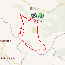
![](/images/other/stat-length.png)
![Trail Walking Blieux - Mourre de Chanier et Pt Mourre par Thon - Photo](https://media.geolcdn.com/t/1900/400/ext.pjpeg?maxdim=2&url=https%3A%2F%2Fstatic1.geolcdn.com%2Fsiteimages%2Fupload%2Ffiles%2F1553511878bg_sport_marche.png)
Mourre de Chanier et Pt Mourre par Thon
GrouGary
User
![Length](/images/other/stat-length.png)
![Max alt](https://static1.geolcdn.com/siteimages/upload/files/1508320355ic_sort_altitude_max_24dp.png)
![Uphill gradient](https://static1.geolcdn.com/siteimages/upload/files/1508320355ic_sort_den_pos_24dp.png)
![Km-Effort](/images/other/stat-length.png)
![Min alt](https://static1.geolcdn.com/siteimages/upload/files/1508320355ic_sort_altitude_min_24dp.png)
![Downhill gradient](https://static1.geolcdn.com/siteimages/upload/files/1508320355ic_sort_den_neg_24dp.png)
![Boucle](https://static1.geolcdn.com/siteimages/upload/files/16400158638029165_repeat_loop_refresh_sync_direction_icon.png)
![Walking](https://static1.geolcdn.com/sitytour/trail-icons/101.png)
6h00
Difficulty : Medium
![Scan this QR Code to open this trail in the SityTrail application](https://capi.geolives.com/qq0zvz2zws4bq2lad0pu/sitytour/trails/2063266/qr.png?size=200)
FREE GPS app for hiking
About
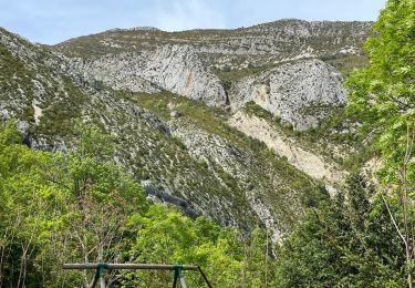
Trail Walking of 15 km to be discovered at Provence-Alpes-Côte d'Azur, Alpes-de-Haute-Provence, Blieux. This trail is proposed by GrouGary.
Description
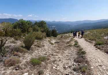
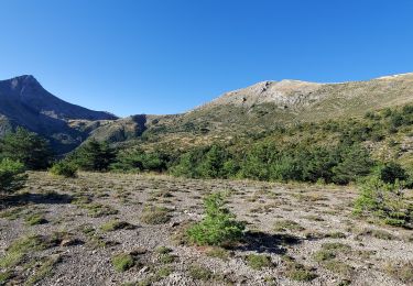
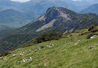
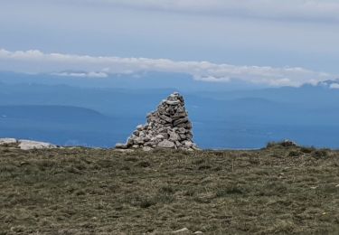
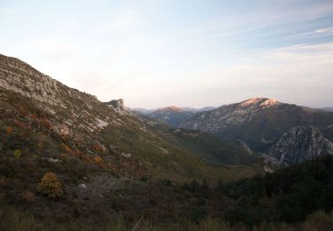
Boucle à partir de Thon. Montée soutenue jusqu'au niveau de la crête des traversière sur puis bifurquer en direction du Mourre de Chanier. De la côte 1884 à 1867, rejoindre le Petit Mourre puis suivre la sente côte 1572, 1523... Plus bas, couper à travers la garrigue, cachant anciennes bergerie et borie.
Pas de difficulté technique mais montée soutenue et longue.
Positioning
Comments
Trails nearby
![Trail Walking Blieux - blieux les trois moures 1087m 18kms - Photo](https://media.geolcdn.com/t/375/260/d127b13b-6828-4952-9438-6bce22421610.jpg&format=jpg&maxdim=2)
![Walking Walking](https://static1.geolcdn.com/sitytour/trail-icons/101.png)
Walking
![](/images/other/stat-length.png)
![](https://static1.geolcdn.com/siteimages/upload/files/16400158638029165_repeat_loop_refresh_sync_direction_icon.png)
![Trail Walking Castellane - Clot d'Aremus - Chasteuil - Chapelle St Jean - Castellane - Photo](https://media.geolcdn.com/t/375/260/cfc0307f-9bdf-497d-99ea-e5d90b985e6c.jpg&format=jpg&maxdim=2)
![Walking Walking](https://static1.geolcdn.com/sitytour/trail-icons/101.png)
Walking
![](/images/other/stat-length.png)
![](https://static1.geolcdn.com/siteimages/upload/files/16400158638029165_repeat_loop_refresh_sync_direction_icon.png)
![Trail Walking Castellane - Chasteuil (04) ; Cadières de Brandis - Photo](https://media.geolcdn.com/t/375/260/e82aa44b-764b-4eaf-855b-7c3c77d91df0.jpg&format=jpg&maxdim=2)
![Walking Walking](https://static1.geolcdn.com/sitytour/trail-icons/101.png)
Walking
![](/images/other/stat-length.png)
![](https://static1.geolcdn.com/siteimages/upload/files/16400158638029165_repeat_loop_refresh_sync_direction_icon.png)
![Trail Walking Castellane - Chasteuil - Cadières de Brandis - Photo](https://media.geolcdn.com/t/375/260/c7d6843e-cfe3-4317-abf1-ad87c071a876.jpg&format=jpg&maxdim=2)
![Walking Walking](https://static1.geolcdn.com/sitytour/trail-icons/101.png)
Walking
![](/images/other/stat-length.png)
![](https://static1.geolcdn.com/siteimages/upload/files/16400158638029165_repeat_loop_refresh_sync_direction_icon.png)
![Trail Walking Castellane - Chasteuil Rougon - Photo](https://media.geolcdn.com/t/375/260/19237a2d-da22-413e-a6b8-ffd688606d3d.jpg&format=jpg&maxdim=2)
![Walking Walking](https://static1.geolcdn.com/sitytour/trail-icons/101.png)
Walking
![](/images/other/stat-length.png)
![](https://static1.geolcdn.com/siteimages/upload/files/16400158638029165_repeat_loop_refresh_sync_direction_icon.png)
![Trail Walking Blieux - blieux chiran 947m 13kms - Photo](https://media.geolcdn.com/t/375/260/f939a6a4-7564-4eb7-9585-8f41e32451d5.jpg&format=jpg&maxdim=2)
![Walking Walking](https://static1.geolcdn.com/sitytour/trail-icons/101.png)
Walking
![](/images/other/stat-length.png)
![](https://static1.geolcdn.com/siteimages/upload/files/16400158638029165_repeat_loop_refresh_sync_direction_icon.png)
![Trail Walking Blieux - pre chauvin - Photo](https://media.geolcdn.com/t/375/260/395b84a4-5146-46dd-97a3-9fe70f48fdfa.jpg&format=jpg&maxdim=2)
![Walking Walking](https://static1.geolcdn.com/sitytour/trail-icons/101.png)
Walking
![](/images/other/stat-length.png)
![](https://static1.geolcdn.com/siteimages/upload/files/16400158638029165_repeat_loop_refresh_sync_direction_icon.png)
![Trail Walking La Palud-sur-Verdon - GR4 Jour 6 Les Chauvets - Mont Chiran 22-05-2021 - Photo](https://media.geolcdn.com/t/375/260/4ba1d0d8-6c50-4ae0-951a-d04da68ac203.jpg&format=jpg&maxdim=2)
![Walking Walking](https://static1.geolcdn.com/sitytour/trail-icons/101.png)
Walking
![](/images/other/stat-length.png)
![](https://static1.geolcdn.com/siteimages/upload/files/16400158638029165_repeat_loop_refresh_sync_direction_icon.png)
![Trail On foot Castellane - 3L1fUyVLtdE - Photo](https://media.geolcdn.com/t/375/260/aa47c5ac-7185-4436-b040-b04700c6577a.jpg&format=jpg&maxdim=2)
![On foot On foot](https://static1.geolcdn.com/sitytour/trail-icons/100.png)
On foot
![](/images/other/stat-length.png)
![](https://static1.geolcdn.com/siteimages/upload/files/16400158638029165_repeat_loop_refresh_sync_direction_icon.png)