![](/images/other/stat-length.png)
![Trail Walking Havelange - Maffe Adeps 2019 - Photo](https://media.geolcdn.com/t/1900/400/ext.pjpeg?maxdim=2&url=https%3A%2F%2Fstatic1.geolcdn.com%2Fsiteimages%2Fupload%2Ffiles%2F1553511878bg_sport_marche.png)
Maffe Adeps 2019
r.genette
User
![Length](/images/other/stat-length.png)
Length
10.9 km
![Max alt](https://static1.geolcdn.com/siteimages/upload/files/1508320355ic_sort_altitude_max_24dp.png)
Max alt
335 m
![Uphill gradient](https://static1.geolcdn.com/siteimages/upload/files/1508320355ic_sort_den_pos_24dp.png)
Uphill gradient
248 m
![Km-Effort](/images/other/stat-length.png)
Km-Effort
14.2 km
![Min alt](https://static1.geolcdn.com/siteimages/upload/files/1508320355ic_sort_altitude_min_24dp.png)
Min alt
233 m
![Downhill gradient](https://static1.geolcdn.com/siteimages/upload/files/1508320355ic_sort_den_neg_24dp.png)
Downhill gradient
252 m
![Boucle](https://static1.geolcdn.com/siteimages/upload/files/16400158638029165_repeat_loop_refresh_sync_direction_icon.png)
Boucle
Yes
Creation date :
2019-04-03 16:03:14.114
Updated on :
2019-04-03 16:08:29.437
![Walking](https://static1.geolcdn.com/sitytour/trail-icons/101.png)
3h00
Difficulty : Easy
![Scan this QR Code to open this trail in the SityTrail application](https://capi.geolives.com/qq0zvz2zws4bq2lad0pu/sitytour/trails/2056505/qr.png?size=200)
FREE GPS app for hiking
About
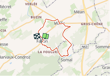
Trail Walking of 10.9 km to be discovered at Wallonia, Namur, Havelange. This trail is proposed by r.genette.
Description
Au départ de l'église de Failon, nous irons direction Buzin, à mi chemin vers Maffe, Somal et retour
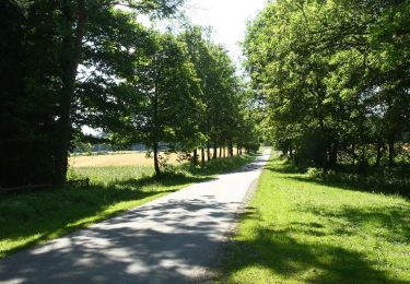
Routes, chemins et sentiers au travers de forêts, champs et villages..
Positioning
Country:
Belgium
Region :
Wallonia
Department/Province :
Namur
Municipality :
Havelange
Location:
Barvaux-Condroz
Start:(Dec)
Start:(UTM)
663048 ; 5578870 (31U) N.
Comments
Trails nearby
![Trail Walking Somme-Leuze - Sentiers d'Art : Boucle16 - Somal - Photo](https://media.geolcdn.com/t/375/260/ext.jpg?maxdim=2&url=https%3A%2F%2Fmedia.geolcdn.com%2Ff%2Feae3e58a-34ce-48df-b7e8-8306bccbd31f.JPG)
![Walking Walking](https://static1.geolcdn.com/sitytour/trail-icons/101.png)
Sentiers d'Art : Boucle16 - Somal
Walking
Medium
(5)
Somme-Leuze,
Wallonia,
Namur,
Belgium
![](/images/other/stat-length.png)
7.4 km | 9.9 km-effort
2h 7min
![](https://static1.geolcdn.com/siteimages/upload/files/16400158638029165_repeat_loop_refresh_sync_direction_icon.png)
Yes
![Trail Walking Havelange - HAVELANGE- Failon- Promenade du Chêne au Gibet - Photo](https://media.geolcdn.com/t/375/260/ext.jpg?maxdim=2&url=https%3A%2F%2Fservices.sitytrail.com%2FGeolivesWS%2FDownloadMedia.ashx%3FTrailID%3D250680%26Media%3D5b284e0f-4186-471a-9bbe-220cdacf1b74.jpg)
![Walking Walking](https://static1.geolcdn.com/sitytour/trail-icons/101.png)
HAVELANGE- Failon- Promenade du Chêne au Gibet
Walking
Very easy
(5)
Havelange,
Wallonia,
Namur,
Belgium
![](/images/other/stat-length.png)
15.8 km | 20 km-effort
4h 17min
![](https://static1.geolcdn.com/siteimages/upload/files/16400158638029165_repeat_loop_refresh_sync_direction_icon.png)
Yes
![Trail Walking Havelange - FAILON (Château-Ferme de Somal) - Photo](https://media.geolcdn.com/t/375/260/ext.jpg?maxdim=2&url=https%3A%2F%2Fservices.sitytrail.com%2FGeolivesWS%2FDownloadMedia.ashx%3FTrailID%3D1004822%26Media%3Dfix__20180712160140.jpg)
![Walking Walking](https://static1.geolcdn.com/sitytour/trail-icons/101.png)
FAILON (Château-Ferme de Somal)
Walking
Easy
(3)
Havelange,
Wallonia,
Namur,
Belgium
![](/images/other/stat-length.png)
10.7 km | 14.2 km-effort
3h 1min
![](https://static1.geolcdn.com/siteimages/upload/files/16400158638029165_repeat_loop_refresh_sync_direction_icon.png)
Yes
![Trail Walking Havelange - Bois, Rivière et champs - Photo](https://media.geolcdn.com/t/375/260/ext.jpg?maxdim=2&url=https%3A%2F%2Fmedia.geolcdn.com%2Ff%2F71798de8-0a71-47ba-81bf-636f8514053b.jpg)
![Walking Walking](https://static1.geolcdn.com/sitytour/trail-icons/101.png)
Bois, Rivière et champs
Walking
Medium
(3)
Havelange,
Wallonia,
Namur,
Belgium
![](/images/other/stat-length.png)
9.3 km | 12.2 km-effort
3h 8min
![](https://static1.geolcdn.com/siteimages/upload/files/16400158638029165_repeat_loop_refresh_sync_direction_icon.png)
Yes
![Trail Walking Havelange - HAVELANGE- Porcheresse- Promenade du Champ du Bois - Photo](https://media.geolcdn.com/t/375/260/ext.jpg?maxdim=2&url=https%3A%2F%2Fservices.sitytrail.com%2FGeolivesWS%2FDownloadMedia.ashx%3FTrailID%3D250669%26Media%3D99c045bc-d8a2-408c-89d7-93e4a625dfbf.jpg)
![Walking Walking](https://static1.geolcdn.com/sitytour/trail-icons/101.png)
HAVELANGE- Porcheresse- Promenade du Champ du Bois
Walking
Easy
(3)
Havelange,
Wallonia,
Namur,
Belgium
![](/images/other/stat-length.png)
14.8 km | 18.5 km-effort
3h 57min
![](https://static1.geolcdn.com/siteimages/upload/files/16400158638029165_repeat_loop_refresh_sync_direction_icon.png)
Yes
![Trail On foot Havelange - Promenade des Tiges - Photo](https://media.geolcdn.com/t/375/260/ext.jpg?maxdim=2&url=https%3A%2F%2Fpivotmedia.tourismewallonie.be%2FOTH-A0-0035-0ZLJ%2FOTH-A0-0035-0ZLJ.jpg)
![On foot On foot](https://static1.geolcdn.com/sitytour/trail-icons/100.png)
Promenade des Tiges
On foot
Easy
Havelange,
Wallonia,
Namur,
Belgium
![](/images/other/stat-length.png)
6.5 km | 7.6 km-effort
1h 42min
![](https://static1.geolcdn.com/siteimages/upload/files/16400158638029165_repeat_loop_refresh_sync_direction_icon.png)
Yes
![Trail On foot Havelange - Promenade du Bois de Porcheresse - Photo](https://media.geolcdn.com/t/375/260/ext.jpg?maxdim=2&url=https%3A%2F%2Fpivotmedia.tourismewallonie.be%2FOTH-A0-0035-12HV%2FOTH-A0-0035-12HV.jpg)
![On foot On foot](https://static1.geolcdn.com/sitytour/trail-icons/100.png)
Promenade du Bois de Porcheresse
On foot
Easy
(2)
Havelange,
Wallonia,
Namur,
Belgium
![](/images/other/stat-length.png)
7.2 km | 8.8 km-effort
2h 0min
![](https://static1.geolcdn.com/siteimages/upload/files/16400158638029165_repeat_loop_refresh_sync_direction_icon.png)
Yes
![Trail On foot Havelange - Promenade de la Fagne - Photo](https://media.geolcdn.com/t/375/260/ext.jpg?maxdim=2&url=https%3A%2F%2Fpivotmedia.tourismewallonie.be%2FOTH-A0-0035-11LO%2FOTH-A0-0035-11LO.jpg)
![On foot On foot](https://static1.geolcdn.com/sitytour/trail-icons/100.png)
Promenade de la Fagne
On foot
Easy
Havelange,
Wallonia,
Namur,
Belgium
![](/images/other/stat-length.png)
6.2 km | 7 km-effort
1h 35min
![](https://static1.geolcdn.com/siteimages/upload/files/16400158638029165_repeat_loop_refresh_sync_direction_icon.png)
Yes
![Trail On foot Havelange - Porcheresse : Promenade du Fond de Havinne - Photo](https://media.geolcdn.com/t/375/260/ext.jpg?maxdim=2&url=https%3A%2F%2Fpivotmedia.tourismewallonie.be%2FOTH-A0-0035-28CB%2FOTH-A0-0035-28CB.jpg)
![On foot On foot](https://static1.geolcdn.com/sitytour/trail-icons/100.png)
Porcheresse : Promenade du Fond de Havinne
On foot
Easy
Havelange,
Wallonia,
Namur,
Belgium
![](/images/other/stat-length.png)
4 km | 4.7 km-effort
1h 4min
![](https://static1.geolcdn.com/siteimages/upload/files/16400158638029165_repeat_loop_refresh_sync_direction_icon.png)
Yes