![](/images/other/stat-length.png)
![Trail Walking Régnié-Durette - Régnié-Durette (17 km - D. 441 m) - Photo](https://media.geolcdn.com/t/1900/400/ext.pjpeg?maxdim=2&url=https%3A%2F%2Fstatic1.geolcdn.com%2Fsiteimages%2Fupload%2Ffiles%2F1553511878bg_sport_marche.png)
Régnié-Durette (17 km - D. 441 m)
Thomasdanielle
User
![Length](/images/other/stat-length.png)
Length
17.5 km
![Max alt](https://static1.geolcdn.com/siteimages/upload/files/1508320355ic_sort_altitude_max_24dp.png)
Max alt
559 m
![Uphill gradient](https://static1.geolcdn.com/siteimages/upload/files/1508320355ic_sort_den_pos_24dp.png)
Uphill gradient
441 m
![Km-Effort](/images/other/stat-length.png)
Km-Effort
23 km
![Min alt](https://static1.geolcdn.com/siteimages/upload/files/1508320355ic_sort_altitude_min_24dp.png)
Min alt
233 m
![Downhill gradient](https://static1.geolcdn.com/siteimages/upload/files/1508320355ic_sort_den_neg_24dp.png)
Downhill gradient
442 m
![Boucle](https://static1.geolcdn.com/siteimages/upload/files/16400158638029165_repeat_loop_refresh_sync_direction_icon.png)
Boucle
Yes
Creation date :
2019-03-25 08:25:36.0
Updated on :
2019-03-26 09:45:49.618
![Walking](https://static1.geolcdn.com/sitytour/trail-icons/101.png)
5h48
Difficulty : Difficult
![Scan this QR Code to open this trail in the SityTrail application](https://capi.geolives.com/qq0zvz2zws4bq2lad0pu/sitytour/trails/2052351/qr.png?size=200)
FREE GPS app for hiking
About
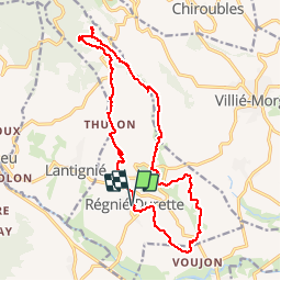
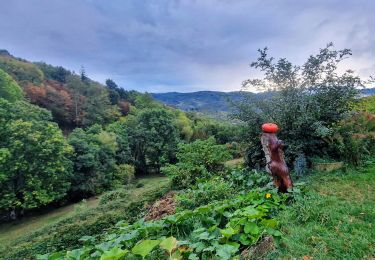
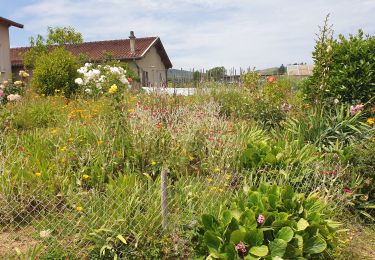
Trail Walking of 17.5 km to be discovered at Auvergne-Rhône-Alpes, Rhône, Régnié-Durette. This trail is proposed by Thomasdanielle.
Description
D/A parking Église
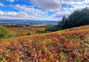
A mon goût beaucoup trop de marche dans les vignes
Pique nique au bord de l'étang
Positioning
Country:
France
Region :
Auvergne-Rhône-Alpes
Department/Province :
Rhône
Municipality :
Régnié-Durette
Location:
Unknown
Start:(Dec)
Start:(UTM)
626776 ; 5110738 (31T) N.
Comments
Trails nearby
![Trail Mountain bike Lantignié - 19e Rando des Primeurs - Photo](https://media.geolcdn.com/t/375/260/ext.jpg?maxdim=2&url=https%3A%2F%2Fservices.sitytrail.com%2FGeolivesWS%2FDownloadMedia.ashx%3FTrailID%3D101810%26Media%3D2084_2.jpg)
![Mountain bike Mountain bike](https://static1.geolcdn.com/sitytour/trail-icons/202.png)
19e Rando des Primeurs
Mountain bike
Difficult
(1)
Lantignié,
Auvergne-Rhône-Alpes,
Rhône,
France
![](/images/other/stat-length.png)
30 km | 45 km-effort
3h 0min
![](https://static1.geolcdn.com/siteimages/upload/files/16400158638029165_repeat_loop_refresh_sync_direction_icon.png)
Yes
![Trail On foot Odenas - SityTrail - 3844657 - etape-3 (1) - Photo](https://media.geolcdn.com/t/375/260/5616cbb8-73f9-47fc-916f-db065bdc249b.jpg&format=jpg&maxdim=2)
![On foot On foot](https://static1.geolcdn.com/sitytour/trail-icons/100.png)
SityTrail - 3844657 - etape-3 (1)
On foot
Difficult
Odenas,
Auvergne-Rhône-Alpes,
Rhône,
France
![](/images/other/stat-length.png)
23 km | 36 km-effort
8h 13min
![](https://static1.geolcdn.com/siteimages/upload/files/16400158638029165_repeat_loop_refresh_sync_direction_icon.png)
No
![Trail Walking Chiroubles - Itinérant Beaujolais rouge étape 5 Chiroubles- Foretal - Photo](https://media.geolcdn.com/t/375/260/bf6c4c39-6cf0-41e3-8fc7-ac4d114e4ee5.jpg&format=jpg&maxdim=2)
![Walking Walking](https://static1.geolcdn.com/sitytour/trail-icons/101.png)
Itinérant Beaujolais rouge étape 5 Chiroubles- Foretal
Walking
Medium
Chiroubles,
Auvergne-Rhône-Alpes,
Rhône,
France
![](/images/other/stat-length.png)
23 km | 32 km-effort
5h 44min
![](https://static1.geolcdn.com/siteimages/upload/files/16400158638029165_repeat_loop_refresh_sync_direction_icon.png)
No
![Trail Walking Beaujeu - Itinérant Beaujolais rouge étape 4 . Malval - Chiroubles - Photo](https://media.geolcdn.com/t/375/260/7e353f10-ae9e-4e5c-a303-dba8e616c8c7.jpg&format=jpg&maxdim=2)
![Walking Walking](https://static1.geolcdn.com/sitytour/trail-icons/101.png)
Itinérant Beaujolais rouge étape 4 . Malval - Chiroubles
Walking
Medium
Beaujeu,
Auvergne-Rhône-Alpes,
Rhône,
France
![](/images/other/stat-length.png)
26 km | 34 km-effort
5h 40min
![](https://static1.geolcdn.com/siteimages/upload/files/16400158638029165_repeat_loop_refresh_sync_direction_icon.png)
No
![Trail Horseback riding Quincié-en-Beaujolais - Quincié CxRozier Court - Photo](https://media.geolcdn.com/t/375/260/ext.jpg?maxdim=2&url=https%3A%2F%2Fstatic1.geolcdn.com%2Fsiteimages%2Fupload%2Ffiles%2F1524743154cheval.jpg)
![Horseback riding Horseback riding](https://static1.geolcdn.com/sitytour/trail-icons/301.png)
Quincié CxRozier Court
Horseback riding
Very difficult
(1)
Quincié-en-Beaujolais,
Auvergne-Rhône-Alpes,
Rhône,
France
![](/images/other/stat-length.png)
28 km | 42 km-effort
5h 33min
![](https://static1.geolcdn.com/siteimages/upload/files/16400158638029165_repeat_loop_refresh_sync_direction_icon.png)
Yes
![Trail Horseback riding Quincié-en-Beaujolais - Quincié Croix ROZEIR - Photo](https://media.geolcdn.com/t/375/260/ext.jpg?maxdim=2&url=https%3A%2F%2Fstatic1.geolcdn.com%2Fsiteimages%2Fupload%2Ffiles%2F1524743154cheval.jpg)
![Horseback riding Horseback riding](https://static1.geolcdn.com/sitytour/trail-icons/301.png)
Quincié Croix ROZEIR
Horseback riding
Very difficult
(1)
Quincié-en-Beaujolais,
Auvergne-Rhône-Alpes,
Rhône,
France
![](/images/other/stat-length.png)
31 km | 46 km-effort
6h 3min
![](https://static1.geolcdn.com/siteimages/upload/files/16400158638029165_repeat_loop_refresh_sync_direction_icon.png)
Yes
![Trail Walking Villié-Morgon - sentier Victor Villié morgon - Photo](https://media.geolcdn.com/t/375/260/b8bcac3e-3fe0-47b1-9d02-47fe9d1beb00.jpg&format=jpg&maxdim=2)
![Walking Walking](https://static1.geolcdn.com/sitytour/trail-icons/101.png)
sentier Victor Villié morgon
Walking
Difficult
Villié-Morgon,
Auvergne-Rhône-Alpes,
Rhône,
France
![](/images/other/stat-length.png)
15.9 km | 21 km-effort
3h 35min
![](https://static1.geolcdn.com/siteimages/upload/files/16400158638029165_repeat_loop_refresh_sync_direction_icon.png)
Yes
![Trail Walking Chiroubles - 2023-05-26_00h30m21_28127-15675317-2 (2) - Photo](https://media.geolcdn.com/t/375/260/ext.jpg?maxdim=2&url=https%3A%2F%2Fstatic1.geolcdn.com%2Fsiteimages%2Fupload%2Ffiles%2F1553511878bg_sport_marche.png)
![Walking Walking](https://static1.geolcdn.com/sitytour/trail-icons/101.png)
2023-05-26_00h30m21_28127-15675317-2 (2)
Walking
Very difficult
(1)
Chiroubles,
Auvergne-Rhône-Alpes,
Rhône,
France
![](/images/other/stat-length.png)
16.9 km | 26 km-effort
5h 49min
![](https://static1.geolcdn.com/siteimages/upload/files/16400158638029165_repeat_loop_refresh_sync_direction_icon.png)
Yes
![Trail Horseback riding Quincié-en-Beaujolais - Quincié Croix - Photo](https://media.geolcdn.com/t/375/260/ext.jpg?maxdim=2&url=https%3A%2F%2Fstatic1.geolcdn.com%2Fsiteimages%2Fupload%2Ffiles%2F1524743154cheval.jpg)
![Horseback riding Horseback riding](https://static1.geolcdn.com/sitytour/trail-icons/301.png)
Quincié Croix
Horseback riding
Difficult
(1)
Quincié-en-Beaujolais,
Auvergne-Rhône-Alpes,
Rhône,
France
![](/images/other/stat-length.png)
26 km | 40 km-effort
5h 14min
![](https://static1.geolcdn.com/siteimages/upload/files/16400158638029165_repeat_loop_refresh_sync_direction_icon.png)
Yes