


Can tho Vietnam

Manon Dalet
User
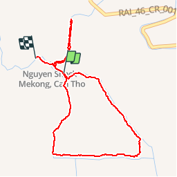

Length
3.2 km

Max alt
11 m

Uphill gradient
28 m
Km-Effort
3.6 km

Min alt
-6 m

Downhill gradient
27 m
Boucle
No
Creation date :
2019-03-25 06:25:53.322
Updated on :
2019-03-25 10:52:36.084
1h03
Difficulty : Very easy

FREE GPS app for hiking
 SityTrail
IGN / Geographical institutes
SityTrail World
The world is yours!
About
Trail Walking of 3.2 km to be discovered at Can Tho City. This trail is proposed by Manon Dalet.
Description
promenade
Positioning
Country:
Viet Nam
Region :
Can Tho City
Department/Province :
Cái Răng
Municipality :
Thành phố Cần Thơ
Location:
Unknown
Start:(Dec)
Start:(UTM)
583763 ; 1102824 (48P) N.
Comments
Trails nearby