![](/images/other/stat-length.png)
![Trail Walking Montbazon - Montbazon - Photo](https://media.geolcdn.com/t/1900/400/b83678d3-61a6-48dc-8977-d020b0d68652.jpg&format=pjpeg&maxdim=2)
Montbazon
fustier
User
![Length](/images/other/stat-length.png)
Length
25 km
![Max alt](https://static1.geolcdn.com/siteimages/upload/files/1508320355ic_sort_altitude_max_24dp.png)
Max alt
100 m
![Uphill gradient](https://static1.geolcdn.com/siteimages/upload/files/1508320355ic_sort_den_pos_24dp.png)
Uphill gradient
169 m
![Km-Effort](/images/other/stat-length.png)
Km-Effort
28 km
![Min alt](https://static1.geolcdn.com/siteimages/upload/files/1508320355ic_sort_altitude_min_24dp.png)
Min alt
51 m
![Downhill gradient](https://static1.geolcdn.com/siteimages/upload/files/1508320355ic_sort_den_neg_24dp.png)
Downhill gradient
195 m
![Boucle](https://static1.geolcdn.com/siteimages/upload/files/16400158638029165_repeat_loop_refresh_sync_direction_icon.png)
Boucle
No
Creation date :
2019-03-20 09:00:04.172
Updated on :
2019-03-26 07:28:34.267
![Walking](https://static1.geolcdn.com/sitytour/trail-icons/101.png)
6h04
Difficulty : Medium
![Scan this QR Code to open this trail in the SityTrail application](https://capi.geolives.com/qq0zvz2zws4bq2lad0pu/sitytour/trails/2049710/qr.png?size=200)
FREE GPS app for hiking
About
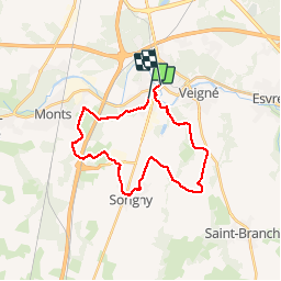
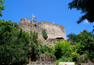
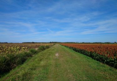
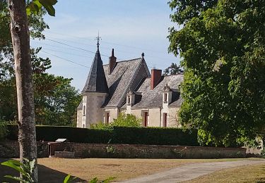
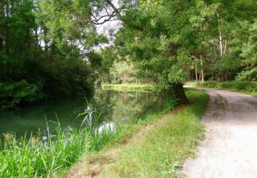
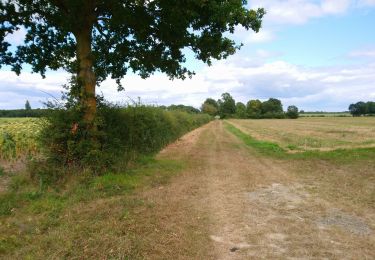
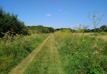
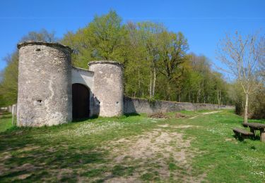
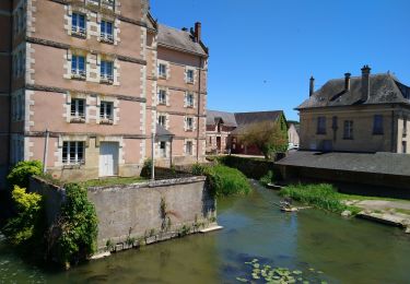
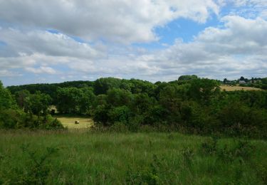
Trail Walking of 25 km to be discovered at Centre-Loire Valley, Indre-et-Loire, Montbazon. This trail is proposed by fustier.
Description
Départ au parking du camping. En fin de parcours nous avons visité le château Du Faucon Noir. Malgré un château fermé à cette époque nous avons été très bien reçu. A découvrir un trompe l'oeil pres du restaurant "L'évidence"
Positioning
Country:
France
Region :
Centre-Loire Valley
Department/Province :
Indre-et-Loire
Municipality :
Montbazon
Location:
Unknown
Start:(Dec)
Start:(UTM)
326772 ; 5239305 (31T) N.
Comments
Trails nearby
![Trail Walking Montbazon - Montbazon - 6.5km 90m 1h40 - 2017 07 23 - Photo](https://media.geolcdn.com/t/375/260/bb42c6a2-228c-4bb0-af88-fcf6e75cd959.jpg&format=jpg&maxdim=2)
![Walking Walking](https://static1.geolcdn.com/sitytour/trail-icons/101.png)
Montbazon - 6.5km 90m 1h40 - 2017 07 23
Walking
Easy
(1)
Montbazon,
Centre-Loire Valley,
Indre-et-Loire,
France
![](/images/other/stat-length.png)
6.5 km | 7.4 km-effort
1h 40min
![](https://static1.geolcdn.com/siteimages/upload/files/16400158638029165_repeat_loop_refresh_sync_direction_icon.png)
Yes
![Trail Walking Sorigny - Sorigny - GR655 la Couarde - 18.4km 60m 4h05 - 2023 09 24 - Photo](https://media.geolcdn.com/t/375/260/41b3e343-63ec-48f3-9efd-62a577d162fd.jpg&format=jpg&maxdim=2)
![Walking Walking](https://static1.geolcdn.com/sitytour/trail-icons/101.png)
Sorigny - GR655 la Couarde - 18.4km 60m 4h05 - 2023 09 24
Walking
Easy
Sorigny,
Centre-Loire Valley,
Indre-et-Loire,
France
![](/images/other/stat-length.png)
18.4 km | 19.2 km-effort
4h 5min
![](https://static1.geolcdn.com/siteimages/upload/files/16400158638029165_repeat_loop_refresh_sync_direction_icon.png)
Yes
![Trail Walking Veigné - Veigné - les Petits Partenais - 14.2km 130m 3h10 - 2022 08 13 - Photo](https://media.geolcdn.com/t/375/260/12fde0e8-2020-45f1-b53f-7c907a510494.jpg&format=jpg&maxdim=2)
![Walking Walking](https://static1.geolcdn.com/sitytour/trail-icons/101.png)
Veigné - les Petits Partenais - 14.2km 130m 3h10 - 2022 08 13
Walking
Easy
Veigné,
Centre-Loire Valley,
Indre-et-Loire,
France
![](/images/other/stat-length.png)
14.2 km | 16 km-effort
3h 10min
![](https://static1.geolcdn.com/siteimages/upload/files/16400158638029165_repeat_loop_refresh_sync_direction_icon.png)
Yes
![Trail Walking Monts - Monts - la Horaie Circuit avec routes - 16.6km 130m 3h40 - 2022 06 16 - Photo](https://media.geolcdn.com/t/375/260/76a7848e-a9d7-4013-ae72-1ef81b68ff52.jpg&format=jpg&maxdim=2)
![Walking Walking](https://static1.geolcdn.com/sitytour/trail-icons/101.png)
Monts - la Horaie Circuit avec routes - 16.6km 130m 3h40 - 2022 06 16
Walking
Easy
Monts,
Centre-Loire Valley,
Indre-et-Loire,
France
![](/images/other/stat-length.png)
16.6 km | 18.3 km-effort
3h 40min
![](https://static1.geolcdn.com/siteimages/upload/files/16400158638029165_repeat_loop_refresh_sync_direction_icon.png)
Yes
![Trail Walking Montbazon - Montbazon - Sorigny Monts GR46A GR655 - 29.6km 210m 6h20 (25mn) - 2021 08 28 - Photo](https://media.geolcdn.com/t/375/260/8ca704d9-dc3c-41b1-aabe-44cf1fa957dd.jpg&format=jpg&maxdim=2)
![Walking Walking](https://static1.geolcdn.com/sitytour/trail-icons/101.png)
Montbazon - Sorigny Monts GR46A GR655 - 29.6km 210m 6h20 (25mn) - 2021 08 28
Walking
Easy
Montbazon,
Centre-Loire Valley,
Indre-et-Loire,
France
![](/images/other/stat-length.png)
30 km | 32 km-effort
6h 20min
![](https://static1.geolcdn.com/siteimages/upload/files/16400158638029165_repeat_loop_refresh_sync_direction_icon.png)
Yes
![Trail Walking Esvres - Larçay - le Chêne Pendu GR46 GR655 Veigné Montbazon - 23.2km 230m 5h20 (25mn) - 2021 08 11 - Photo](https://media.geolcdn.com/t/375/260/bef14b6a-df34-48bf-b03d-e33ce373ae61.jpg&format=jpg&maxdim=2)
![Walking Walking](https://static1.geolcdn.com/sitytour/trail-icons/101.png)
Larçay - le Chêne Pendu GR46 GR655 Veigné Montbazon - 23.2km 230m 5h20 (25mn)...
Walking
Easy
Esvres,
Centre-Loire Valley,
Indre-et-Loire,
France
![](/images/other/stat-length.png)
23 km | 26 km-effort
5h 20min
![](https://static1.geolcdn.com/siteimages/upload/files/16400158638029165_repeat_loop_refresh_sync_direction_icon.png)
Yes
![Trail Walking Joué-lès-Tours - Joué-lès-Tours - 12.9km 100m 2h25 - 2021 04 03 - Photo](https://media.geolcdn.com/t/375/260/bbf5eebf-1891-4c59-b051-368eada2ef0c.jpg&format=jpg&maxdim=2)
![Walking Walking](https://static1.geolcdn.com/sitytour/trail-icons/101.png)
Joué-lès-Tours - 12.9km 100m 2h25 - 2021 04 03
Walking
Easy
Joué-lès-Tours,
Centre-Loire Valley,
Indre-et-Loire,
France
![](/images/other/stat-length.png)
12.9 km | 14.2 km-effort
2h 25min
![](https://static1.geolcdn.com/siteimages/upload/files/16400158638029165_repeat_loop_refresh_sync_direction_icon.png)
Yes
![Trail Walking Veigné - Veigné - boucles via GR46A - 19.9km 210m 4h20 - 2020 05 29 - Photo](https://media.geolcdn.com/t/375/260/a5ad2662-2ed9-425f-8fe1-05da50922710.jpg&format=jpg&maxdim=2)
![Walking Walking](https://static1.geolcdn.com/sitytour/trail-icons/101.png)
Veigné - boucles via GR46A - 19.9km 210m 4h20 - 2020 05 29
Walking
Easy
Veigné,
Centre-Loire Valley,
Indre-et-Loire,
France
![](/images/other/stat-length.png)
19.9 km | 23 km-effort
4h 20min
![](https://static1.geolcdn.com/siteimages/upload/files/16400158638029165_repeat_loop_refresh_sync_direction_icon.png)
Yes
![Trail Walking Monts - Monts - Artannes-sur-Indre - 11.1km 100m 2h20 - 2020 05 22 - Photo](https://media.geolcdn.com/t/375/260/d621beeb-9ad9-4377-8be9-8910941162ce.jpg&format=jpg&maxdim=2)
![Walking Walking](https://static1.geolcdn.com/sitytour/trail-icons/101.png)
Monts - Artannes-sur-Indre - 11.1km 100m 2h20 - 2020 05 22
Walking
Very easy
Monts,
Centre-Loire Valley,
Indre-et-Loire,
France
![](/images/other/stat-length.png)
11.1 km | 12.5 km-effort
2h 20min
![](https://static1.geolcdn.com/siteimages/upload/files/16400158638029165_repeat_loop_refresh_sync_direction_icon.png)
Yes