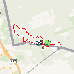
![](/images/other/stat-length.png)
![Trail Walking Antwerp - Wildernissen - Photo](https://media.geolcdn.com/t/1900/400/ext.pjpeg?maxdim=2&url=https%3A%2F%2Fstatic1.geolcdn.com%2Fsiteimages%2Fupload%2Ffiles%2F1553511878bg_sport_marche.png)
Wildernissen
speedybike
User
![Length](/images/other/stat-length.png)
![Max alt](https://static1.geolcdn.com/siteimages/upload/files/1508320355ic_sort_altitude_max_24dp.png)
![Uphill gradient](https://static1.geolcdn.com/siteimages/upload/files/1508320355ic_sort_den_pos_24dp.png)
![Km-Effort](/images/other/stat-length.png)
![Min alt](https://static1.geolcdn.com/siteimages/upload/files/1508320355ic_sort_altitude_min_24dp.png)
![Downhill gradient](https://static1.geolcdn.com/siteimages/upload/files/1508320355ic_sort_den_neg_24dp.png)
![Boucle](https://static1.geolcdn.com/siteimages/upload/files/16400158638029165_repeat_loop_refresh_sync_direction_icon.png)
![Walking](https://static1.geolcdn.com/sitytour/trail-icons/101.png)
1h32
Difficulty : Medium
![Scan this QR Code to open this trail in the SityTrail application](https://capi.geolives.com/qq0zvz2zws4bq2lad0pu/sitytour/trails/204412/qr.png?size=200)
FREE GPS app for hiking
About
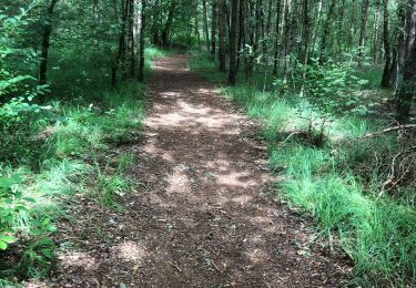
Trail Walking of 6.4 km to be discovered at Flanders, Antwerp, Antwerp. This trail is proposed by speedybike.
Description
De wildernissen achter de afgebroken watertoren geven verbinding naar de Nederlandse bossen achter Putte om zo door te gaan naar de Klmthoutse Hei via de Grote Meren. Op Belgisch gebied hebben ze verbinding naar het Morethusbos met zijn Ravenhof. Het gebied heeft een mengeling van zand, grond, slijk en leuke singletrails met korte hoogteverschillen en wat ik noem mijn Bike-o-meter ( beetje fysieke gezondheidstest ). Dit is een korte rit maar je kan er kort of lang je hartje ophalen..
Positioning
Comments
Trails nearby
![Trail On foot Antwerp - Wandelpad Eekhoorn - Photo](https://media.geolcdn.com/t/375/260/659c5ebd-94be-43dd-a6ca-7482051fd6ba.jpeg&format=jpg&maxdim=2)
![On foot On foot](https://static1.geolcdn.com/sitytour/trail-icons/100.png)
On foot
![](/images/other/stat-length.png)
![](https://static1.geolcdn.com/siteimages/upload/files/16400158638029165_repeat_loop_refresh_sync_direction_icon.png)
![Trail On foot Antwerp - Wandelpad Specht - Photo](https://media.geolcdn.com/t/375/260/ea3f5fe8-f467-4734-a44c-09edb7f8108d.jpeg&format=jpg&maxdim=2)
![On foot On foot](https://static1.geolcdn.com/sitytour/trail-icons/100.png)
![Trail Walking Woensdrecht - Stoppelbergen Zuidpolder Ossendtecht - Photo](https://media.geolcdn.com/t/375/260/47ffec97-04b0-4eb7-9184-82bea4c120ee.jpg&format=jpg&maxdim=2)
![Walking Walking](https://static1.geolcdn.com/sitytour/trail-icons/101.png)
Walking
![](/images/other/stat-length.png)
![](https://static1.geolcdn.com/siteimages/upload/files/16400158638029165_repeat_loop_refresh_sync_direction_icon.png)
![Trail Walking Stabroek - Kapellen 22 km - Photo](https://media.geolcdn.com/t/375/260/be0a6501-0d47-4ffc-85cc-a71ae92a46ba.jpg&format=jpg&maxdim=2)
![Walking Walking](https://static1.geolcdn.com/sitytour/trail-icons/101.png)
![Trail On foot Woensdrecht - Wandelpad Mier - Photo](https://media.geolcdn.com/t/375/260/3a83af8a-158d-4fce-bc2a-0035eb382702.jpeg&format=jpg&maxdim=2)
![On foot On foot](https://static1.geolcdn.com/sitytour/trail-icons/100.png)
On foot
![](/images/other/stat-length.png)
![](https://static1.geolcdn.com/siteimages/upload/files/16400158638029165_repeat_loop_refresh_sync_direction_icon.png)
![Trail On foot Woensdrecht - Wandelpad Haas - Photo](https://media.geolcdn.com/t/375/260/1ceda016-209b-4e2f-a261-50038dde5e53.jpeg&format=jpg&maxdim=2)
![On foot On foot](https://static1.geolcdn.com/sitytour/trail-icons/100.png)
On foot
![](/images/other/stat-length.png)
![](https://static1.geolcdn.com/siteimages/upload/files/16400158638029165_repeat_loop_refresh_sync_direction_icon.png)
![Trail Walking Woensdrecht - De Kriekelaereduinen - Photo](https://media.geolcdn.com/t/375/260/9490dcd1-0ec3-4949-951e-4e9ff06e4e99.jpg&format=jpg&maxdim=2)
![Walking Walking](https://static1.geolcdn.com/sitytour/trail-icons/101.png)
Walking
![](/images/other/stat-length.png)
![](https://static1.geolcdn.com/siteimages/upload/files/16400158638029165_repeat_loop_refresh_sync_direction_icon.png)
![Trail Cycle Stabroek - f-belgie-rondje-kalmthoutse-heide-brabantse-wal - Photo](https://media.geolcdn.com/t/375/260/ext.jpg?maxdim=2&url=https%3A%2F%2Fstatic1.geolcdn.com%2Fsiteimages%2Fupload%2Ffiles%2F1524743154velo.jpg)
![Cycle Cycle](https://static1.geolcdn.com/sitytour/trail-icons/200.png)
Cycle
![](/images/other/stat-length.png)
![](https://static1.geolcdn.com/siteimages/upload/files/16400158638029165_repeat_loop_refresh_sync_direction_icon.png)
![Trail Mountain bike Antwerp - m-belgie-zandvliet-01 - Photo](https://media.geolcdn.com/t/375/260/ext.jpg?maxdim=2&url=https%3A%2F%2Fstatic1.geolcdn.com%2Fsiteimages%2Fupload%2Ffiles%2F1524743154velo.jpg)
![Mountain bike Mountain bike](https://static1.geolcdn.com/sitytour/trail-icons/202.png)
Mountain bike
![](/images/other/stat-length.png)
![](https://static1.geolcdn.com/siteimages/upload/files/16400158638029165_repeat_loop_refresh_sync_direction_icon.png)